Mesoscale Discussion for North & Central Alabama: Tornado Watch Soon to be Issued
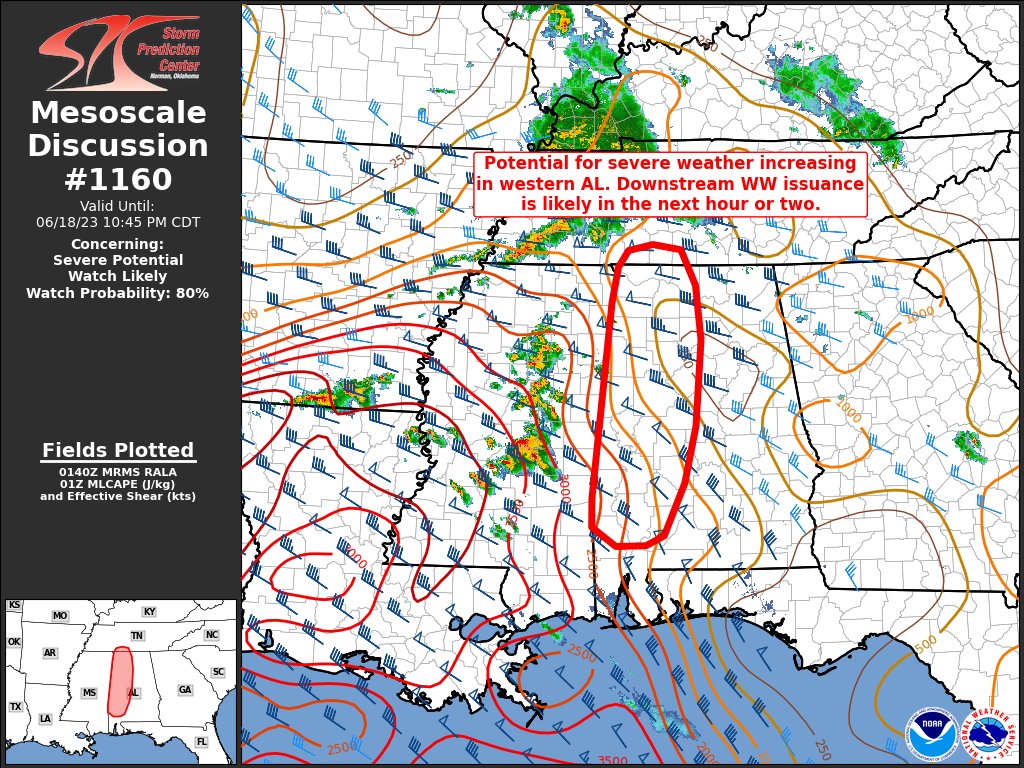
With the current uptick in severe weather activity across Central Mississippi, and the storms projected to continue to build and strengthen, the SPC has drawn up a mesoscale discussion for North & Central Alabama about the issuance of a new Tornado Watch. Here is the text from the discussion:
SUMMARY… A risk for all hazards of severe weather appears to be increasing across western AL. Weather Watch issuance is likely within the next hour, depending on ongoing convective trends.
DISCUSSION… Multiple supercells have developed across central MS and are moving eastward through WW335. The 19/00z JAN sounding featured an uncapped boundary layer with nearly 4000 J/kg of MLCAPE, effective shear around 45 KTS, and significant veering low-level shear contributing to 455 J/kg of ESRH (along with 235 J/kg in the lowest 1 km AGL). Despite generally weak synoptic forcing, these supercells acquired mid- and low-level mesocyclones rather quickly in this environment. At least one radar-indicated tornado has been observed, and all severe hazards remain possible as the storms approach the MS/AL border.
Convective evolution in the highlighted area remains somewhat uncertain due to overturned air from convection earlier today. Temperatures and dewpoints in western AL are generally a few degrees cooler than the environment in which the storms are currently located. This is contributing to substantially increasing MLCIN with eastward extent through the delineated area. This could contribute to rapidly weakening storms deeper into AL and decreasing severe hazards later tonight. However, modest low-level advection is anticipated, which could lessen inhibition. The degree to which this may occur in a narrow zone ahead of the ongoing supercells remains uncertain. Should this occur, the threat for all severe hazards with these supercells — as well as any additional storms that develop in northern MS — could persist for the next few hours across western AL. Due to this scenario, downstream WW issuance appears likely during the next couple of hours.
Category: Alabama's Weather, ALL POSTS, Severe Weather
About the Author (Author Profile)
Scott Martin is an operational meteorologist, professional graphic artist, musician, husband, and father. Not only is Scott a member of the National Weather Association, but he is also the Central Alabama Chapter of the NWA president. Scott is also the co-founder of Racecast Weather, which provides forecasts for many racing series across the USA. He also supplies forecasts for the BassMaster Elite Series events including the BassMaster Classic.Subscribe
If you enjoyed this article, subscribe to receive more just like it.


