The Mid-Afternoon Report — Rogue Showers Out There; Severe Storms Possible Tomorrow
THE CENTRAL ALABAMA WEEKEND
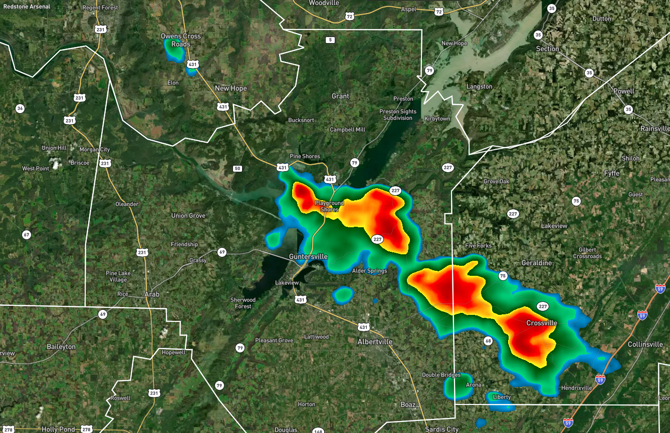
While Central Alabama is dry today, we do have some rogue shower activity up in the Tennessee Valley. Some shower activity stretches from Owens Cross Roads to the southeast over Guntersville and down to Crossville. Those are moving southward and will affect portions of Etowah county shortly.
Temperatures are in the upper 80s to the lower 90s and are very close to the afternoon highs. A few showers could affect the northeastern parts of Central Alabama during the daylight hours, but the rest of the area will stay dry with partly to mostly sunny skies. For tonight, we could start seeing some showers and storms move into the northwestern parts of the area before daybreak, otherwise, we’ll be dry. Lows in the upper 60s to the lower 70s.
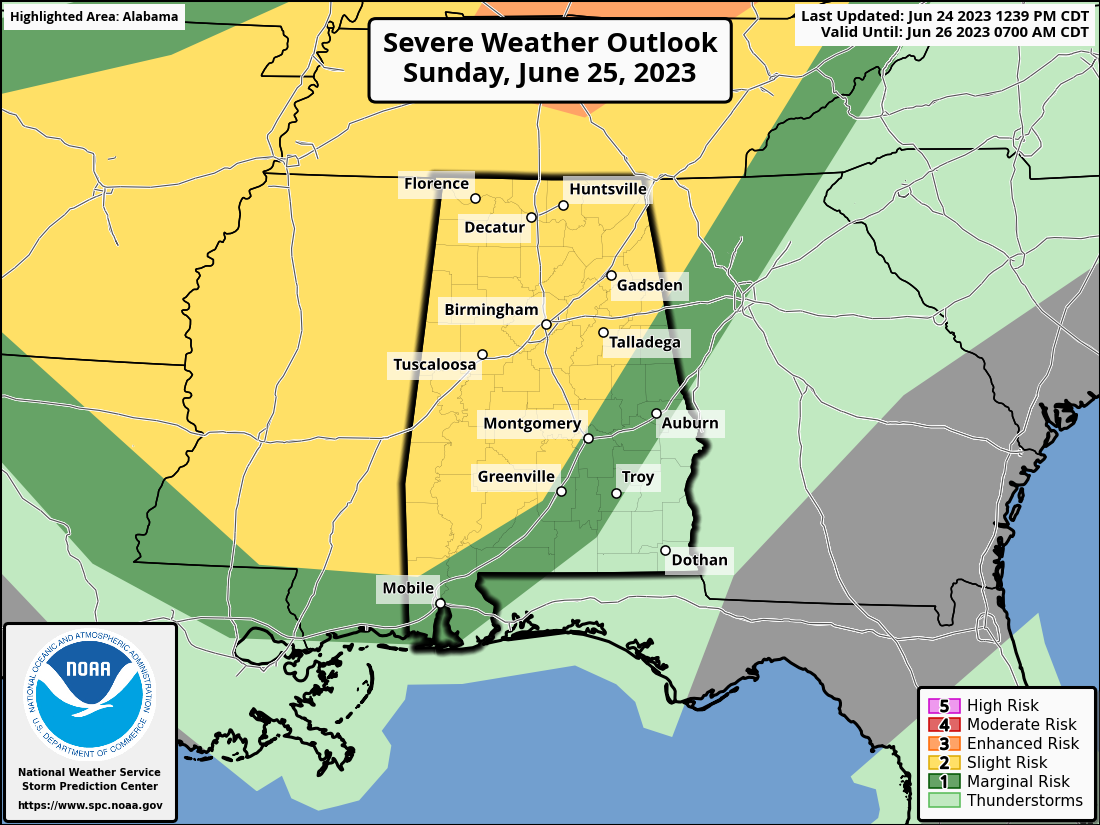
It now looks like severe storms will be possible on Sunday for all of north and Central Alabama all the way down to Auburn and Troy. There will be multiple rounds of storms throughout the day and into the evening hours, with the main threats of large hail and damaging winds. It will be incredibly muggy as well, and heat index values could reach as high as 106º as daytime highs will be in the upper 80s to the lower 90s. Stay weather aware.
THE LAST WORK WEEK OF JUNE
The cold front will continue to move toward the area on Monday, that will keep our weather unsettled. Scattered showers and storms will be possible throughout the day, and a few strong storms will be possible as well. Right now, the better dynamics will stay off to our north. Highs in the upper 80s to the lower 90s.
The weakening front will move into the area on Tuesday, and will keep a small chance of a few isolated to scattered showers and storms possible along and ahead of it. Highs in the upper 80s to the mid 90s.
Ridging starts to build in over the area, and temperatures will be hotter. We’ll have sunny skies with highs in the lower to mid 90s.
We go even hotter on Thursday with mainly sunny skies, but a few of us may see an isolated afternoon shower or storm. Highs in the lower to mid 90s in the east and up into the upper 90s in the west and southwest.
And at the end of the forecast period on Friday… No change in the weather as we’ll continue to have mostly sunny skies and highs in the 90s. Only a small chance of a few scattered showers and storms to bring very little heat relief to some of us.
THE TROPICS
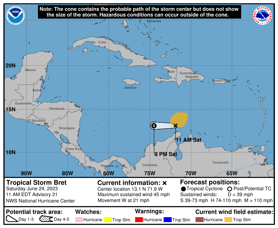
Tropical Storm Brett is barely hanging on as a tropical cyclone as the circulation is barely closed with very light winds on the system’s south side. However, winds up to 45 mph are still occurring north of the center and are strongest in the deep convection. However, continued northwesterly vertical wind shear should cause the storm to weaken and the circulation to open up soon, possibly even later today.
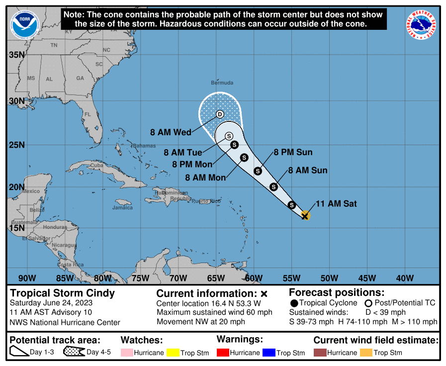
Shear is also starting to increase with Tropical Storm Cindy, and it is likely the system has peaked in intensity with weakening not far behind. Winds are currently at 60 mph. With increasing shear expected to shift southwesterly in a day or so, and that combined with a fairly dry mid-level airmass, should contribute to continued decay over the next several days. It seems more likely Cindy will succumb to the increasingly unfavorable environmental conditions and dissipate within the next five days.
BEACH FORECAST CENTER
Get the latest weather and rip current forecasts for the beaches from Dauphin Island, AL, to Panama City Beach, FL, on our Beach Forecast Center page. There, you can select the forecast of the region that you are interested in.
ON THIS DAY IN WEATHER HISTORY
1975 – A fairly innocuous looking thunderstorm at JFK airport in New York City produced a microburst that caused Eastern Airline 66 to crash 2400 feet short of the runway. 112 people were killed. The control tower, only 1.2 miles away, was never affected by the microburst as the outflow was held back by a sustained sea breeze front.
ADVERTISE ON THE BLOG!
Don’t miss out! We can customize a creative, flexible, and affordable package that will suit your organization’s needs. Contact Bill Murray at (205) 687-0782.
E-FORECAST
Get the Alabama Wx Weather Blog’s Seven-Day Forecast delivered directly to your inbox by email twice daily. It is the most detailed weather forecast available in Central Alabama. Subscribe here… It’s free!
CONNECT WITH THE BLOG ON SOCIAL MEDIA
You can find the Alabama Wx Weather Blog on Facebook and Twitter.
WEATHERBRAINS
If you are crazy about weather, this is THE podcast for you! Listen to the latest released episode each Tuesday, or catch up on any episodes that you have missed. The WeatherBrains crew includes your host, James Spann, plus other notable geeks like Troy Kimmel, Bill Murray, Rick Smith, James Aydelott, Jen Narramore, Dr. Neil Jacobs, and Dr. Kim Klockow-McClain. They bring together a wealth of weather knowledge and experience for another fascinating podcast about weather. Available at WeatherBrains.com, or on Apple Podcasts, Google Podcasts, Spotify, or Stitcher.
Category: Alabama's Weather, ALL POSTS, Severe Weather, Tropical
About the Author (Author Profile)
Scott Martin is an operational meteorologist, professional graphic artist, musician, husband, and father. Not only is Scott a member of the National Weather Association, but he is also the Central Alabama Chapter of the NWA president. Scott is also the co-founder of Racecast Weather, which provides forecasts for many racing series across the USA. He also supplies forecasts for the BassMaster Elite Series events including the BassMaster Classic.Subscribe
If you enjoyed this article, subscribe to receive more just like it.


