Heavy Rain, Flooding Threat Highlighted by the Weather Prediction Center
Mesoscale Precipitation Discussion 0726
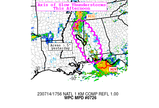
NWS Weather Prediction Center College Park MD
159 PM EDT Fri Jul 14 2023
Areas affected…Mississippi, Alabama, and Florida Panhandle
Concerning…Heavy rainfall…Flash flooding likely
Valid 141751Z – 142330Z
Summary…An axis of slow moving and heavy thunderstorms will
continue to develop between a line of thunderstorms moving east
along the MS/TN line and persistent activity over the western FL
Panhandle. Under the axis between these features is the footprint
of the extreme (5-10″) rainfall from yesterday over east-central
Mississippi into western Alabama. Given the sensitive nature of
these areas, there is likely to be further flash flooding this
afternoon there and localized elsewhere in the area of concern.
Discussion…Radar imagery depicts an MCS tracking east over
northern MS into western TN that is approaching northern AL at
1745Z. The south end of this line is rapidly developing with
rainfall rates likely 1″ to 2″/hr. An axis of scattered
thunderstorms then extends south-southeast to the western FL
Panhandle which is where remnant MCS activity persists after the
extreme rainfall this morning that occurred along the Emerald
Coast of FL (and west of the associated MCV south of Panama City).
Along this axis is very moist air with PW of 2.0 to 2.2″ (over +2
sigma), strong instability with MLCAPE 2000 to 3000 J/kg, and
light steering flow of 10kt or less from the north. A continued
expectation for a slow net westward propagation of the activity
over FL into higher instability and eastward progression of the
MCS along the TN border may further cause slow motion a pivoting
of the axis near the central MS/AL border where the extreme
rainfall fell yesterday.
All 12Z CAMs feature an axis of slow thunderstorms this afternoon
near the MS/AL border, though this is earlier than forecast.
Recent HRRRs also feature this activity, though only for a few
hours before dying off. The length of this event is uncertain
given how slow the flow is which may cause activity to rain out.
However, given the ample instability and robust moisture, there
should be plenty of outflow boundaries to reignite activity.
Therefore, there is a likely risk for further and possibly
considerable flash flooding over these sensitive areas along the
central MS/AL border and more localized flash flooding over far
western FL into southern AL and northeast MS into northwest AL
where 3hr FFG is generally 2.5 to 3″.
Jackson
Category: Alabama's Weather, ALL POSTS, Severe Weather
About the Author (Author Profile)
Bill Murray is the President of The Weather Factory. He is the site's official weather historian and a weekend forecaster. He also anchors the site's severe weather coverage. Bill Murray is the proud holder of National Weather Association Digital Seal #0001 @wxhistorianSubscribe
If you enjoyed this article, subscribe to receive more just like it.


