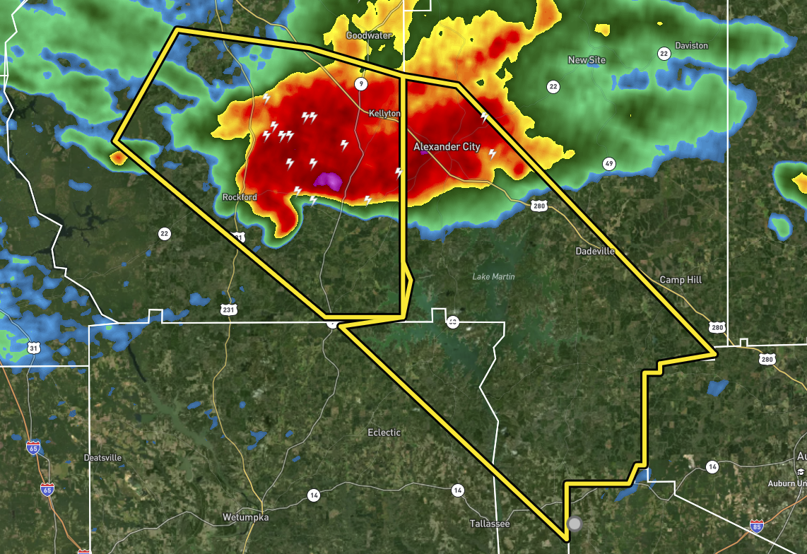
Severe T-Storm Warning for Parts of Elmore, Tallapoosa Co. Until 11:30 pm
The National Weather Service in Birmingham has issued a
* Severe Thunderstorm Warning for…
Northeastern Elmore County in east central Alabama…
Central Tallapoosa County in east central Alabama…
* Until 1130 PM CDT.
* At 1009 PM CDT, a severe thunderstorm was located over Cottage
Grove, or near Rockford, moving southeast at 30 mph.
HAZARD…Ping pong ball size hail and 60 mph wind gusts.
SOURCE…Radar indicated.
IMPACT…People and animals outdoors will be injured. Expect hail
damage to roofs, siding, windows, and vehicles. Expect
wind damage to roofs, siding, and trees.
* Locations impacted include…
Alexander City, Dadeville, Jacksons’ Gap, Martin Dam, Eastern Lake
Martin, Liberty City, Western Lake Martin, Northern Lake Martin,
Southern Lake Martin, Kowaliga Bridge, Wind Creek State Park, Still
Waters Resort, Susannah Crossing, Maxwell Gunter Recreation Area,
Blue Creek Marina, Dare Park, Reeltown and Yates Reservoir.
PRECAUTIONARY/PREPAREDNESS ACTIONS…
For your protection move to an interior room on the lowest floor of a
building.
Category: Alabama's Weather, ALL POSTS, Severe Weather
About the Author (Author Profile)
Scott Martin is an operational meteorologist, professional graphic artist, musician, husband, and father. Not only is Scott a member of the National Weather Association, but he is also the Central Alabama Chapter of the NWA president. Scott is also the co-founder of Racecast Weather, which provides forecasts for many racing series across the USA. He also supplies forecasts for the BassMaster Elite Series events including the BassMaster Classic.Subscribe
If you enjoyed this article, subscribe to receive more just like it.


