Tropical Depression Number Six Forms as the Atlantic Awakens
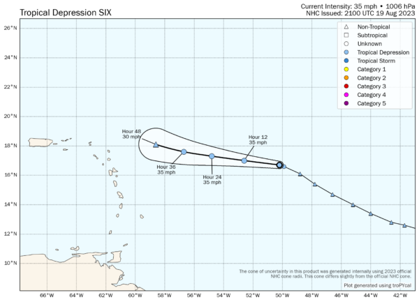
Tropical Depression Number 6 has formed this afternoon about 850 miles east of the northern Leeward Islands.
It is not expected to become a tropical storm, and in fact, it is expected to weaken to a remnant low pressure system by Monday as it turns northwest to the east of the islands.
I will have an update on all the systems in the Atlantic that present a threat of tropical development over the next seven days, as well as Eastern Pacific Hurricane Hilary, which will become a historic storm tomorrow in Southern California.
BULLETIN
Tropical Depression Six Advisory Number 1
NWS National Hurricane Center Miami FL AL062023
500 PM AST Sat Aug 19 2023
…NEW DEPRESSION FORMS…
…EXPECTED TO BE SHORT-LIVED…
SUMMARY OF 500 PM AST…2100 UTC…INFORMATION
———————————————-
LOCATION…16.7N 50.2W
ABOUT 855 MI…1375 KM E OF THE NORTHERN LEEWARD ISLANDS
MAXIMUM SUSTAINED WINDS…35 MPH…55 KM/H
PRESENT MOVEMENT…WNW OR 290 DEGREES AT 16 MPH…26 KM/H
MINIMUM CENTRAL PRESSURE…1006 MB…29.71 INCHES
WATCHES AND WARNINGS
——————–
There are no coastal watches or warnings in effect.
DISCUSSION AND OUTLOOK
———————-
At 500 PM AST (2100 UTC), the center of Tropical Depression Six was
located near latitude 16.7 North, longitude 50.2 West. The
depression is moving toward the west-northwest near 16 mph (26 km/h)
and a turn to the west is expected later today with a gradual
decrease in forward motion over the next day or so. On Monday, the
depression is expected to turn back to the west-northwest.
Maximum sustained winds are near 35 mph (55 km/h) with higher gusts.
The depression is expected to be short-lived and become a remnant
low by Monday.
The estimated minimum central pressure is 1006 mb (29.71 inches).
HAZARDS AFFECTING LAND
———————-
None
NEXT ADVISORY
————-
Next complete advisory at 1100 PM AST.
$$
Forecaster Bucci
Category: Alabama's Weather, ALL POSTS, Tropical


