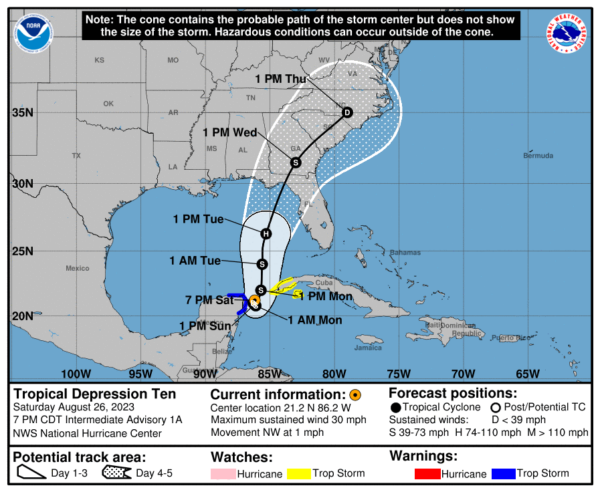
TD 10 Nearly Stationary over the Yucatán Peninsula
At this point, no new developments with TD 10, except for a very slow crawl to the northwest has started since the last update. The forecast track has remained the same, but any slight jog to the west will bring more activity into portions of Central Alabama. If this system outperforms the forecasts, you may see that jog to the west in the forecast track within the coming days. However, a weaker system will usually jog further eastward. We’ll keep our eyes on it until we say bye to it by the end of the work week. Here is the 7 pm update from the NHC:
SUMMARY OF 700 PM CDT…0000 UTC…INFORMATION
———————————————-
LOCATION…21.2N 86.2W
ABOUT 45 MI…70 KM ENE OF COZUMEL MEXICO
MAXIMUM SUSTAINED WINDS…30 MPH…45 KM/H
PRESENT MOVEMENT…NW OR 315 DEGREES AT 1 MPH…2 KM/H
MINIMUM CENTRAL PRESSURE…1005 MB…29.68 INCHES
WATCHES AND WARNINGS
——————–
SUMMARY OF WATCHES AND WARNINGS IN EFFECT:
A Tropical Storm Warning is in effect for…
* Yucatán Peninsula from Tulum to Rio Lagartos, including Cozumel
A Tropical Storm Watch is in effect for…
* Pinar del Rio and the Isle of Youth
DISCUSSION AND OUTLOOK
———————-
At 700 PM CDT (0000 UTC), the center of Tropical Depression Ten was located near latitude 21.2 North, longitude 86.2 West. The depression is nearly stationary, and little overall movement is expected through Sunday. A slow, generally northward, motion is expected to begin on Monday. On the forecast track, the center will move into the southeastern Gulf of Mexico by Monday. Maximum sustained winds are near 30 mph (45 km/h) with higher gusts. Gradual strengthening is forecast during the next few days, and the system is likely to become a tropical storm on Sunday. The system could then become a hurricane over the eastern Gulf of Mexico by Tuesday. The estimated minimum central pressure is 1005 mb (29.68 inches).
HAZARDS AFFECTING LAND
———————-
RAINFALL: Tropical Depression Ten is expected to produce rainfall amounts of 3 to 6 inches, with isolated higher amounts of 10 inches, across portions of the eastern Yucatán Peninsula. Across western Cuba, rainfall amounts of 4 to 8 inches, with isolated maximum amounts of 12 inches, are expected. This rainfall may lead to flash and urban flooding, and landslides across western Cuba. Heavy rainfall is also likely to impact portions of the Gulf Coast and portions of the Southeast by mid- to late next week.
WIND: Tropical storm conditions are expected to begin over portions of the warning area over the Yucatán Peninsula on Sunday. Tropical storm conditions are possible within the watch area over western Cuba beginning on Sunday.
STORM SURGE: Minor coastal flooding is expected within the Tropical Storm Warning area over the Yucatán Peninsula in areas of onshore winds.
Category: Alabama's Weather, ALL POSTS, Tropical


