Hurricane Watches & Storm Surge Watches Issued Ahead of Idalia’s Arrival
The 4 pm update is out, and while there has been no change in Idalia’s strength at this point, the National Hurricane Center has issued hurricane and storm surge watches for portions of the Florida Gulf Coast. Here is the text from the latest update:
…STORM SURGE AND HURRICANE WATCHES ISSUED FOR PORTIONS OF THE FLORIDA GULF COAST…
SUMMARY OF 400 PM CDT…2100 UTC…INFORMATION
———————————————-
LOCATION…20.1N 85.5W
ABOUT 95 MI…155 KM ESE OF COZUMEL MEXICO
MAXIMUM SUSTAINED WINDS…40 MPH…65 KM/H
PRESENT MOVEMENT…NE OR 40 DEGREES AT 3 MPH…6 KM/H
MINIMUM CENTRAL PRESSURE…995 MB…29.39 INCHES
WATCHES AND WARNINGS
——————–
A Tropical Storm Warning is in effect for…
* Yucatán Peninsula from Tulum to Rio Lagartos, including Cozumel
* Pinar del Rio Cuba
A Storm Surge Watch is in effect for…
* Chokoloskee to Indian Pass Florida, including Tampa Bay
A Hurricane Watch is in effect for…
* Englewood to Indian Pass Florida, including Tampa Bay
A Tropical Storm Watch is in effect for…
* Isle of Youth Cuba
* South of Englewood to Chokoloskee Florida
* Dry Tortugas Florida
DISCUSSION AND OUTLOOK
———————-
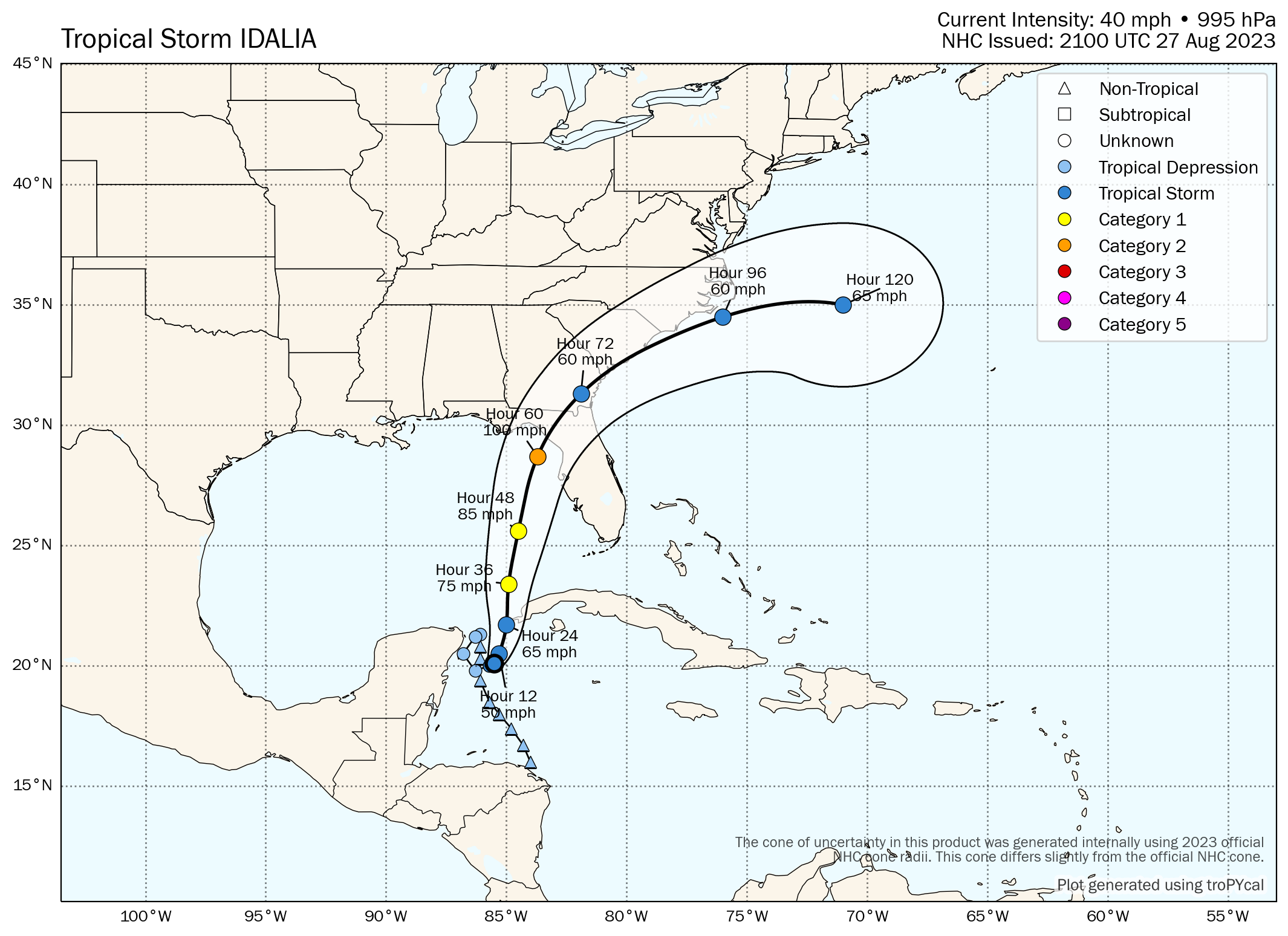
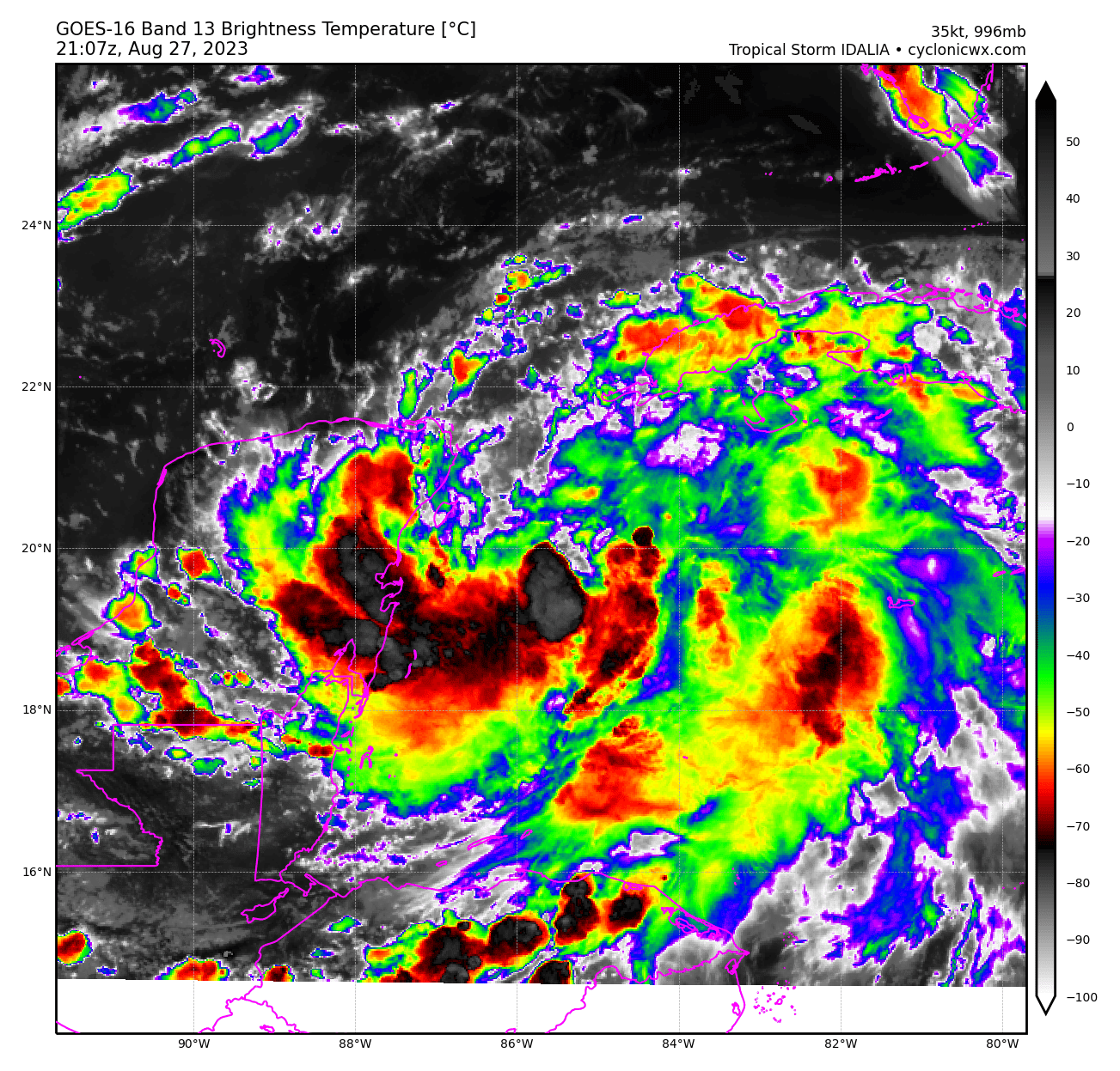
At 400 PM CDT (2100 UTC), the center of Tropical Storm Idalia was located near latitude 20.1 North, longitude 85.5 West. Idalia is moving toward the northeast near 3 mph (6 km/h). A slow, possibly erratic, motion is expected overnight. A generally northward to north-northeastward motion at an increasing forward speed is expected on Monday and Tuesday. On the forecast track, the center will move over the eastern Gulf of Mexico on Monday and Tuesday, and approach the northeast Gulf coast late Tuesday.
Maximum sustained winds are near 40 mph (65 km/h) with higher gusts. Strengthening is forecast, and Idalia is expected to become a hurricane over the southeastern Gulf of Mexico by early Tuesday. Additional strengthening is likely while Idalia approaches the northeastern Gulf coast. Tropical-storm-force winds extend outward up to 70 miles (110 km) from the center. The estimated minimum central pressure is 995 mb (29.39 inches).
HAZARDS AFFECTING LAND
———————-
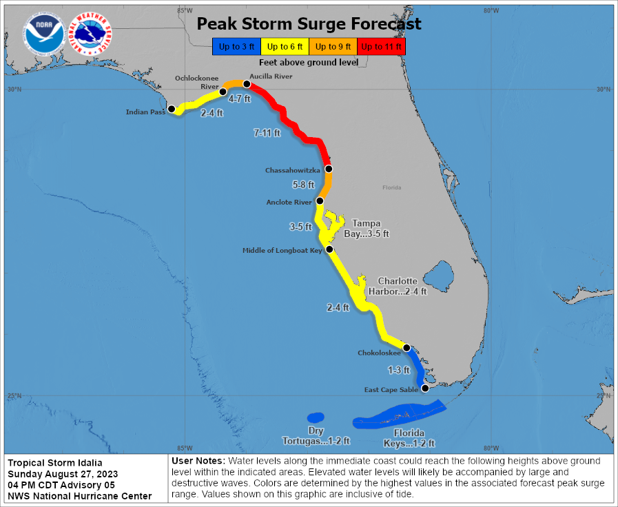
STORM SURGE: The combination of a dangerous storm surge and the tide will cause normally dry areas near the coast to be flooded by rising waters moving inland from the shoreline. The water could reach the following heights above ground somewhere in the indicated areas if the peak surge occurs at the time of high tide…
Aucilla River, FL to Chassahowitzka, FL…7-11 ft
Chassahowitzka, FL to Anclote River, FL…5-8 ft
Ochlockonee River, FL to Aucilla River, FL…4-7 ft
Anclote River, FL to Middle of Longboat Key, FL…3-5 ft
Tampa Bay…3-5 ft
Middle of Longboat Key, FL to Chokoloskee, FL…2-4 ft
Charlotte Harbor…2-4 ft
Indian Pass, FL to Ochlockonee River, FL…2-4 ft
Chokoloskee, FL to East Cape Sable, FL…1-3 ft
Florida Keys…1-2 ft
The deepest water will occur along the immediate coast in areas of onshore winds, where the surge will be accompanied by large and dangerous waves. Surge-related flooding depends on the relative timing of the surge and the tidal cycle, and can vary greatly over short distances.
Storm surge will raise water levels by as much as 2 to 4 feet above normal tide levels along the southern coast of Pinar del Rio, Cuba. Near the coast, the surge will be accompanied by large waves.
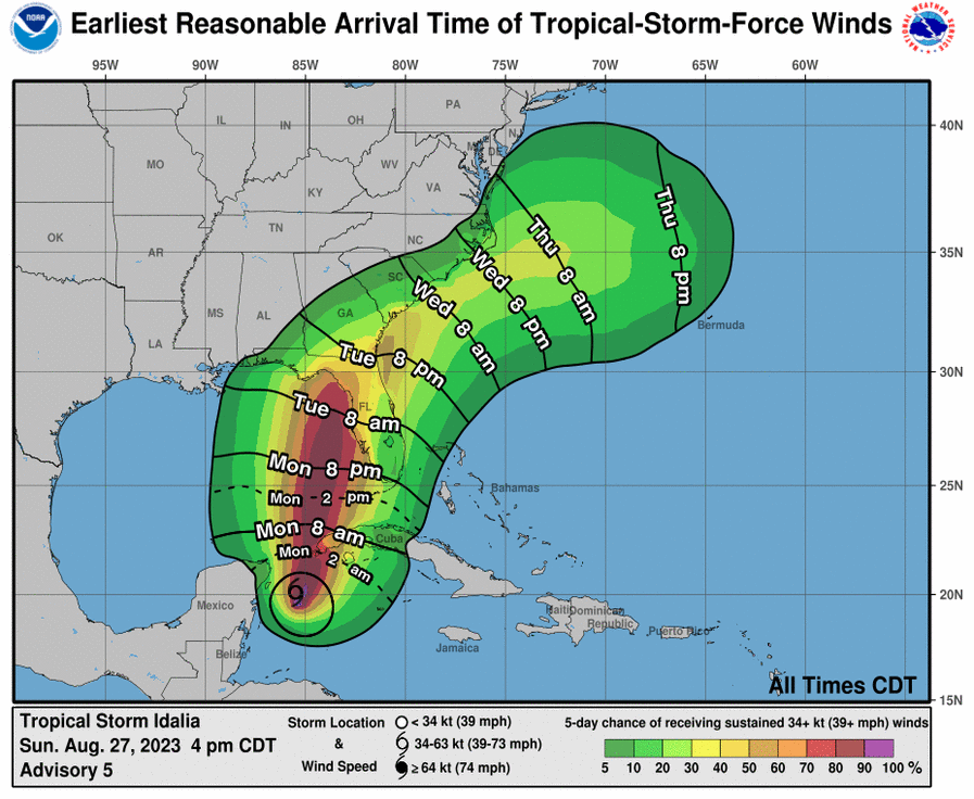
WIND: Tropical storm conditions are expected over portions of the warning area over the Yucatán Peninsula and western Cuba through Monday. Tropical storm conditions are possible within the watch area on the Isle of Youth on Monday. Hurricane conditions are possible within the hurricane watch area by late Tuesday or Wednesday, with tropical storm conditions possible by Tuesday. Tropical storm conditions are possible in the Dry Tortugas beginning late Monday and within the tropical storm watch area along the Florida Gulf coast on Tuesday.
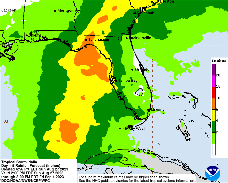
RAINFALL: Idalia is expected to produce the following rainfall amounts:
• Portions of the eastern Yucatán Peninsula: 2 to 4 inches, with isolated higher totals of 6 inches.
• Western Cuba: 3 to 6 inches, with isolated higher totals of 10 inches.
• Portions of the west coast of Florida, the Florida Panhandle, and southern Georgia: From Tuesday into Wednesday, 3 to 6 inches, with isolated higher totals of 10 inches.
• Heavy rainfall is also likely to spread into portions of the Carolinas by Wednesday into Thursday.
• This rainfall may lead to flash and urban flooding, and landslides across western Cuba. Scattered flash and urban flooding can also be expected across portions of the west coast of Florida, the Florida Panhandle and portions of the Southeast U.S. by Tuesday into Thursday.
Category: Alabama's Weather, ALL POSTS, Tropical
About the Author (Author Profile)
Scott Martin is an operational meteorologist, professional graphic artist, musician, husband, and father. Not only is Scott a member of the National Weather Association, but he is also the Central Alabama Chapter of the NWA president. Scott is also the co-founder of Racecast Weather, which provides forecasts for many racing series across the USA. He also supplies forecasts for the BassMaster Elite Series events including the BassMaster Classic.Subscribe
If you enjoyed this article, subscribe to receive more just like it.


