10 p.m. Advisory: 110 mph, 958 millibars; New Forecast is for Category Four at Landfall
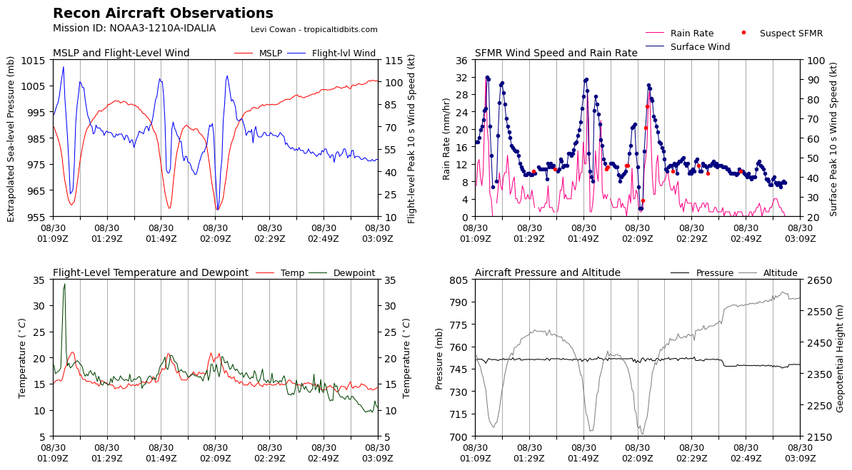
The NOAA Hurricane Hunters continue to find lower pressure on their passes through the storm.
The new forecast from the NHC is now calling for 130 mph before landfall, which would make it a powerful category four hurricane.
The new forecast is just a little west of previous one. Some of the models are even further west, so we are still waiting for the turn to happen.
The official track brings it within 40 miles of Tallahassee. The wind forecast there has increased about 10 mph. Winds could gust to 70 mph in Florida’s capital city. This would be devastating to the heavy canopy of trees there.
Hurricane warnings extend up well into South Georgia. There will be tremendous power outages well inland.
The new forecast maximum surge is for up to 16 feet.
The current surge at Cedar Key is 1.5 feet. Around Tampa Bay, it is running 2 feet.
The record surge at Cedar Key is ten feet in the 1842. Idalia could produce a higher storm surge.
There is still time to leave vulnerable locations in the storm surge warning area. But do it now.
BULLETIN
Hurricane Idalia Advisory Number 14
NWS National Hurricane Center Miami FL AL102023
1100 PM EDT Tue Aug 29 2023
…IDALIA STILL STRENGTHENING…
…FORECAST TO BE AN EXTREMELY DANGEROUS CATEGORY 4 INTENSITY AT
LANDFALL…
SUMMARY OF 1100 PM EDT…0300 UTC…INFORMATION
———————————————–
LOCATION…27.7N 84.5W
ABOUT 125 MI…200 KM W OF TAMPA FLORIDA
ABOUT 185 MI…300 KM S OF TALLAHASSEE FLORIDA
MAXIMUM SUSTAINED WINDS…110 MPH…175 KM/H
PRESENT MOVEMENT…N OR 10 DEGREES AT 18 MPH…30 KM/H
MINIMUM CENTRAL PRESSURE…958 MB…28.29 INCHES
WATCHES AND WARNINGS
——————–
CHANGES WITH THIS ADVISORY:
The Tropical Storm Warning for the Dry Tortugas is discontinued,
and the Tropical Storm Watch for the Lower Florida Keys is
discontinued.
SUMMARY OF WATCHES AND WARNINGS IN EFFECT:
A Storm Surge Warning is in effect for…
* Englewood northward to Indian Pass, including Tampa Bay
A Hurricane Warning is in effect for…
* Middle of Longboat Key northward to Indian Pass, including Tampa
Bay
A Tropical Storm Warning is in effect for…
* Chokoloskee northward to the Middle of Longboat Key
* West of Indian Pass to Mexico Beach
* Sebastian Inlet Florida to Surf City North Carolina
A Storm Surge Watch is in effect for…
* Bonita Beach northward to Englewood, including Charlotte Harbour
* Mouth of the St. Mary’s River to South Santee River South
Carolina
* Beaufort Inlet to Drum Inlet North Carolina
* Neuse and Pamlico Rivers North Carolina
A Hurricane Watch is in effect for…
* Mouth of the St. Mary’s River to Edisto Beach South Carolina
A Tropical Storm Watch is in effect for…
* North of Surf City North Carolina to the North Carolina/Virginia
border
* Pamlico and Albemarle Sounds
A Hurricane Warning means that hurricane conditions are expected
somewhere within the warning area. Preparations to protect life
and property should be rushed to completion.
A Storm Surge Warning means there is a danger of life-threatening
inundation, from rising water moving inland from the coastline,
during the next 36 hours in the indicated locations. For a
depiction of areas at risk, please see the National Weather
Service Storm Surge Watch/Warning Graphic, available at
hurricanes.gov. This is a life-threatening situation. Persons
located within these areas should take all necessary actions to
protect life and property from rising water and the potential for
other dangerous conditions. Promptly follow evacuation and other
instructions from local officials.
A Tropical Storm Warning means that tropical storm conditions are
expected somewhere within the warning area.
A Storm Surge Watch means there is a possibility of life-
threatening inundation, from rising water moving inland from the
coastline, in the indicated locations during the next 48 hours.
For a depiction of areas at risk, please see the National Weather
Service Storm Surge Watch/Warning Graphic, available at
hurricanes.gov.
A Hurricane Watch means that hurricane conditions are possible
within the watch area.
A Tropical Storm Watch means that tropical storm conditions are
possible within the watch area, generally within 48 hours.
Additional warnings will likely be required tonight or on Wednesday.
For storm information specific to your area in the United
States, including possible inland watches and warnings, please
monitor products issued by your local National Weather Service
forecast office.
DISCUSSION AND OUTLOOK
———————-
At 1100 PM EDT (0300 UTC), the center of Hurricane Idalia was
located near latitude 27.7 North, longitude 84.5 West. Idalia is
moving toward the north near 18 mph (30 km/h). A northward to
north-northeastward motion is expected through tonight, with
Idalia’s center forecast to reach the Big Bend coast of Florida on
Wednesday morning. After landfall, the center of Idalia is forecast
to turn toward the northeast and east-northeast, moving near or
along the coasts of Georgia, South Carolina, and North Carolina late
Wednesday and Thursday.
Hurricane Hunter aircraft data indicate that maximum sustained
winds are near 110 mph (175 km/h) with higher gusts. Additional
strengthening is forecast, and Idalia is expected to become a
major hurricane during the next few hours before it reaches the Big
Bend coast of Florida. Idalia is likely to still be a hurricane
while moving across southern Georgia, and possibly when it reaches
the coast of Georgia or southern South Carolina on Wednesday.
Hurricane-force winds extend outward up to 25 miles (35 km) from the
center and tropical-storm-force winds extend outward up to 160 miles
(260 km).
The estimated minimum central pressure based on Hurricane Hunter
aircraft observations is 958 mb (28.29 inches).
HAZARDS AFFECTING LAND
———————-
Key messages for Idalia can be found in the Tropical Cyclone
Discussion under AWIPS header MIATCDAT5 and WMO header WTNT45 KNHC,
and on the web at hurricanes.gov/text/MIATCDAT5.shtml
STORM SURGE: The combination of a dangerous storm surge and the
tide will cause normally dry areas near the coast to be flooded by
rising waters moving inland from the shoreline. The water could
reach the following heights above ground somewhere in the indicated
areas if the peak surge occurs at the time of high tide…
Wakulla/Jefferson County line, FL to Yankeetown, FL…12-16 ft
Ochlockonee River, FL to Wakulla/Jefferson County line, FL…8-12 ft
Yankeetown to Chassahowitzka, FL…7-11 ft
Chassahowitzka, FL to Anclote River, FL…6-9 ft
Carrabelle, FL to Ochlockonee River, FL…5-8 ft
Anclote River, FL to Middle of Longboat Key, FL…4-6 ft
Tampa Bay…4-6 ft
Middle of Longboat Key, FL to Englewood, FL…3-5 ft
Indian Pass, FL to Carrabelle, FL…3-5 ft
Englewood, FL to Bonita Beach, FL…2-4 ft
Charlotte Harbor…2-4 ft
Mouth of the St. Mary’s River to South Santee, SC…2-4 ft
Beaufort Inlet to Drum Inlet, NC…2-4 ft
Pamlico and Neuse Rivers…2-4 ft
South of Bonita Beach to Chokoloskee, FL…1-3 ft
South Santee, SC to Beaufort Inlet, NC…1-3 ft
Drum Inlet to Duck, NC…1-3 ft
Chokoloskee, FL to East Cape Sable, FL…1-3 ft
Flagler/Volusia County Line, FL to Mouth of St. Mary’s River…1-3
ft
Indian Pass to Mexico Beach…1 to 3 ft
Florida Keys…1-2 ft
The deepest water will occur along the immediate coast in areas of
onshore winds, where the surge will be accompanied by large and
dangerous waves. Surge-related flooding depends on the relative
timing of the surge and the tidal cycle, and can vary greatly over
short distances. For information specific to your area, please see
products issued by your local National Weather Service forecast
office.
WIND: Hurricane conditions are expected within the hurricane
warning area in Florida early Wednesday morning, with tropical
storm conditions beginning within the next few hours.
Tropical storm conditions will begin within the tropical storm
warning area along the Florida Gulf coast and the Florida west coast
soon.
Hurricane conditions are possible within the hurricane watch area
along the coasts of Georgia and South Carolina Wednesday and
Wednesday night.
Tropical storm conditions are expected to begin on Wednesday in the
warning area along the east coast of Florida, Georgia, and South
Carolina, and spread into North Carolina Wednesday night and
Thursday. Tropical storm conditions are possible within the watch
area in North Carolina by Thursday.
RAINFALL: Idalia is expected to produce a swath of 4 to 8 inches of
rainfall with isolated maxima up to 12 inches from the Florida Big
Bend through central Georgia and South Carolina, and through eastern
North Carolina into Thursday. These rainfall amounts will lead to
areas of flash, urban, and moderate river flooding, with locally
considerable impacts.
SURF: Swells generated by Idalia are affecting the southwestern
coast of Florida and will spread northward and westward to the
north-central Gulf coast through Wednesday. These swells are
likely to cause life-threatening surf and rip current conditions.
Please consult products from your local weather office.
TORNADOES: A few tornadoes are possible tonight from the coast of
west-central Florida northward into the Florida Big Bend region.
The tornado risk will shift into southeast Georgia and the coastal
Carolinas on Wednesday.
NEXT ADVISORY
————-
Next intermediate advisory at 200 AM EDT.
Next complete advisory at 500 AM EDT.
$$
Forecaster Pasch
About the Author (Author Profile)
Bill Murray is the President of The Weather Factory. He is the site's official weather historian and a weekend forecaster. He also anchors the site's severe weather coverage. Bill Murray is the proud holder of National Weather Association Digital Seal #0001 @wxhistorianSubscribe
If you enjoyed this article, subscribe to receive more just like it.


