Saturday Briefing — Some Showers/Storms Today; Not Bad for Sunday & Labor Day
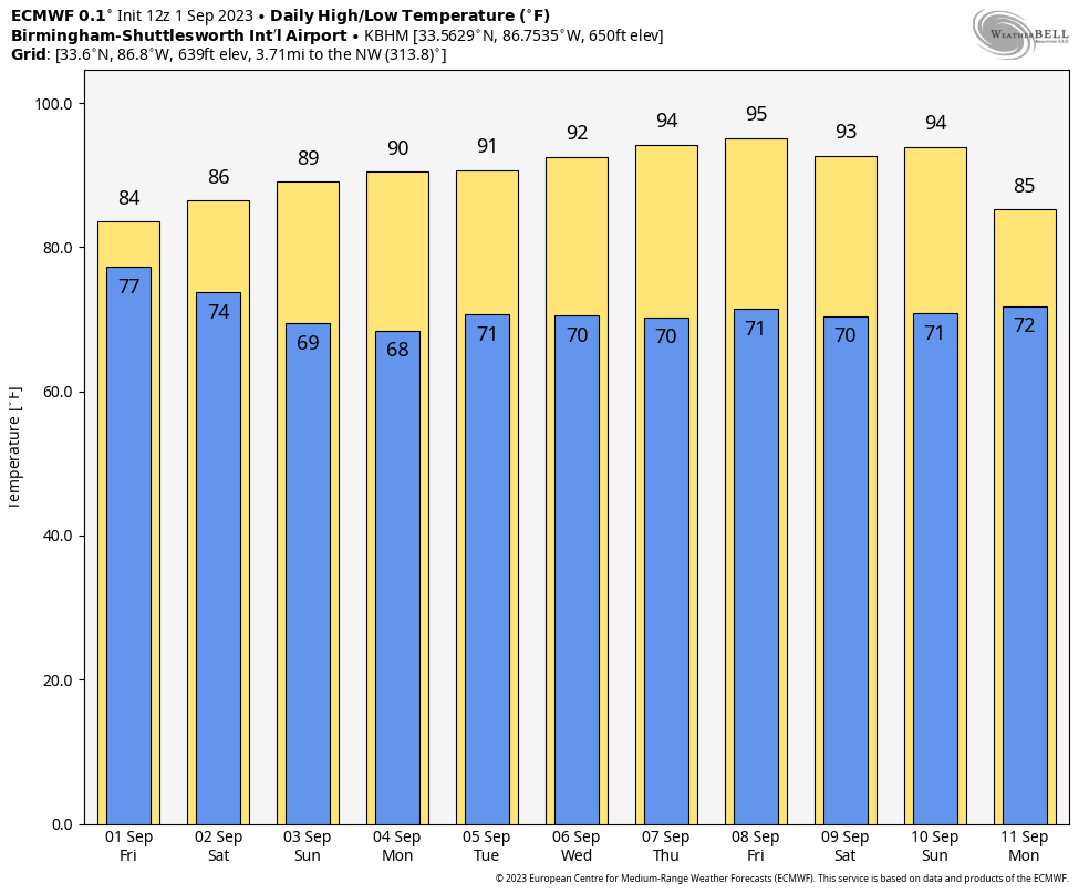
With high pressure beginning to move in from the northeast, drier air will begin to flow into Central Alabama today. Much of the northeastern half of the area will remain dry, but a stray shower or two might sneak up on us during the day. Much of the activity will be over the southwest half of the area where scattered showers and storms will be possible. Afternoon highs ranging from the upper 70s to the mid 80s.
Sunday will be a dry day across much of Central Alabama as dry air will have filtered in except for locations right along the AL/MS state line, and that is where a few isolated to scattered afternoon showers and storms will be possible. Highs will be up in the mid to upper 80s.
Labor Day will be just a touch warmer across the area, but we’ll keep nearly the same forecast as we saw on Sunday. We’ll have dry conditions across much of the area with a very small chance of an isolated shower or two over the extreme western counties of the area. Highs in the mid 80s to the lower 90s.
Tuesday will be a not-so-bad late summer day in Central Alabama, as dry air and high pressure will be in place. No rain is expected and highs in the upper 80s to the lower 90s.
Heat levels will rise on Wednesday as we’ll remain dry with plenty of sunshine. Highs in the lower to mid 90s. The good news is that heat index values look to stay close to the actual temperature.
Thursday will be another day with plenty of sunshine, but there may be just enough moisture in the atmosphere for a very small chance of an isolated afternoon shower. Don’t expect too much in the way of precipitation as dewpoints will remain lower. Highs in the lower to mid 90s.
And at the end of the forecast period, and the end of the work week, on Friday… weather conditions will be almost an exact duplicate of Thursday. Plenty of sun and hot with a very small chance of an isolated afternoon shower. Highs in the lower to mid 90s.
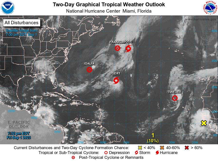
As of late Friday night, we have three active tropical systems and one area of interest out there over the Atlantic Ocean. Franklin and Idalia have become remnant lows after both hitting major hurricane strength earlier this week. Tropical Storm Jose will not last long and will be absorbed by the remnants of Franklin. Tropical Storm Gert may strengthen a little on Saturday, but she will eventually dissipate by Monday evening. Tropical Depression #12 may become a brief-lived tropical storm on Saturday, but is expected to degenerate into a remnant low on Sunday evening. Lastly, a tropical wave is forecast to move over the eastern Atlantic Ocean at some point during the next 24 hours and has a medium chance of becoming a depression around mid-week. For now, there is no threat to the United States from any tropical systems.
Category: ALL POSTS
About the Author (Author Profile)
Scott Martin is an operational meteorologist, professional graphic artist, musician, husband, and father. Not only is Scott a member of the National Weather Association, but he is also the Central Alabama Chapter of the NWA president. Scott is also the co-founder of Racecast Weather, which provides forecasts for many racing series across the USA. He also supplies forecasts for the BassMaster Elite Series events including the BassMaster Classic.Subscribe
If you enjoyed this article, subscribe to receive more just like it.


