Tropical Storm Lee is on the Board; Will Become a Powerful Hurricane in Coming Days
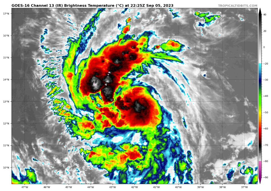
Tropical depression 13 is better organized this afternoon with good outflow and an inner core appears to be forming.
The NHC says it is not a matter of if, but when rapid intensification will occur.
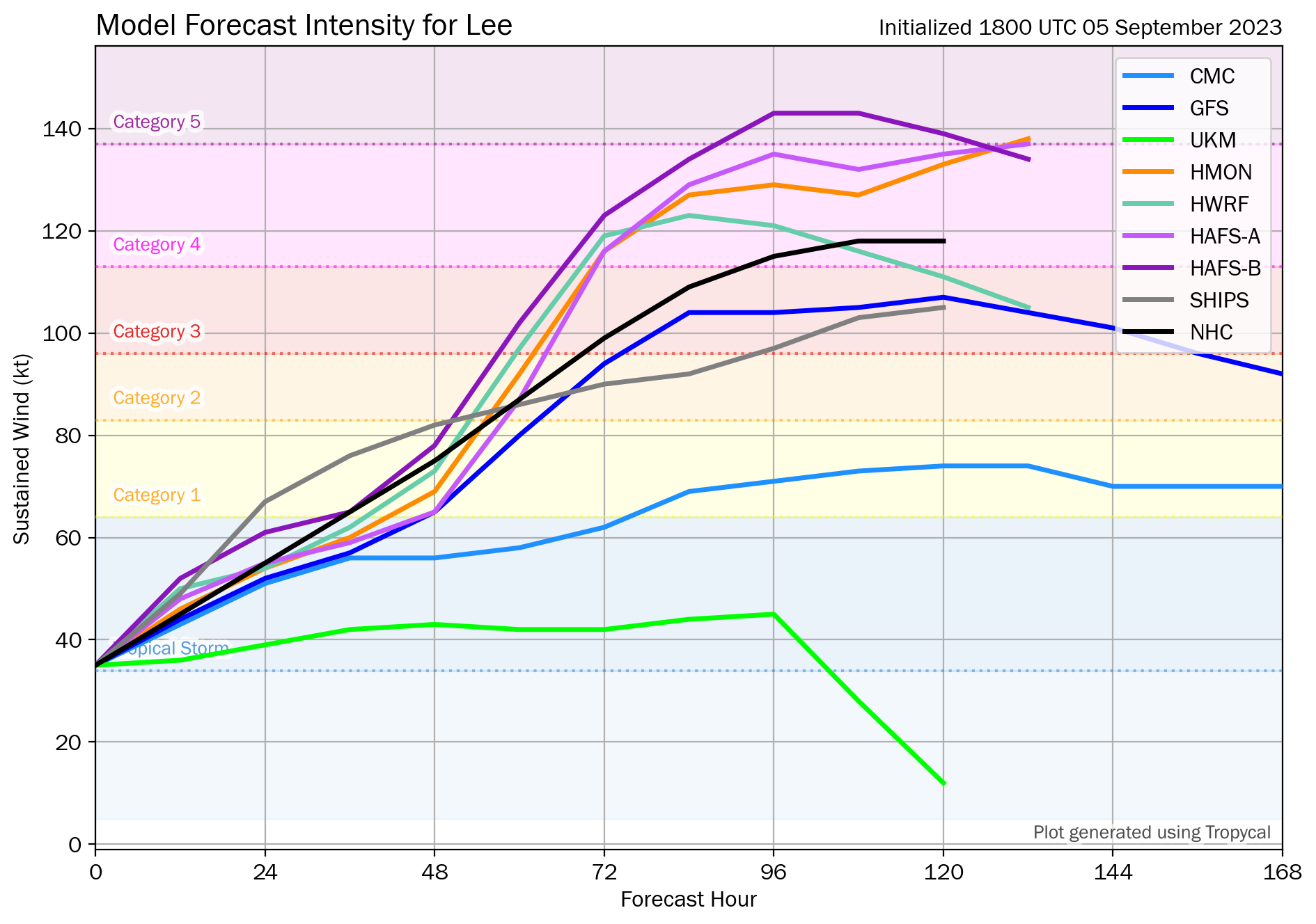
The forecast is increased to 144 mph at 120 hours, but it will likely be stronger, with very warm water to traverse and nothing to really hold it back. There will be a little shear for the next two days that may keep intensification from being runaway during that period, but rapid intensification will eventually occur.
Here are intensity forecasts…some even take it to Cat 5.
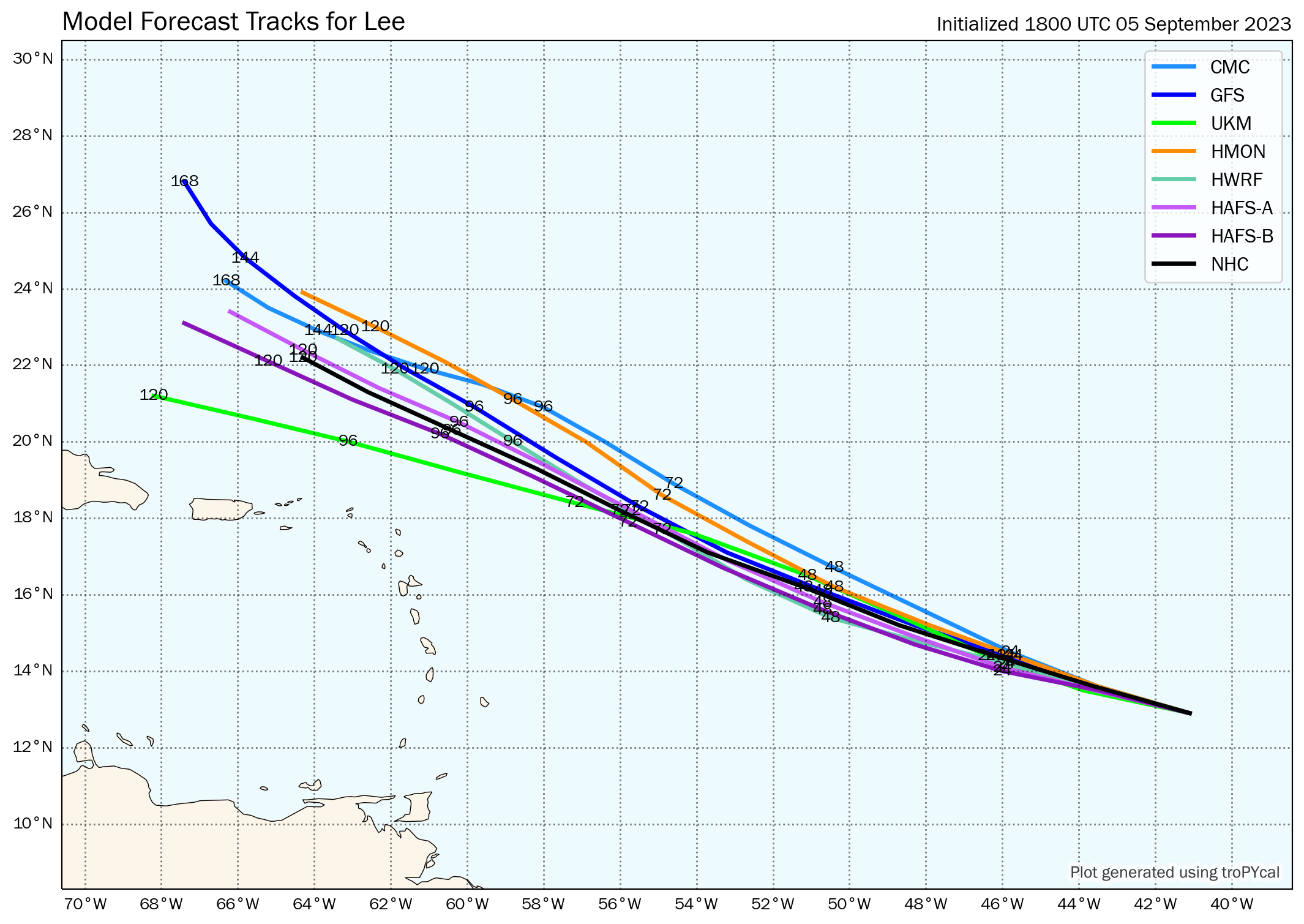
Here is the latest spaghetti plot of the major global models. Note that the UK met takes it more westward, which we still can’t rule out.
The Multi-Moodel Consensus has trended a little further north over the past few runs, with is good news for the northern Leewards islands and Puerto Rico. But they are still not out of the woods yet and we are monitoring carefully.
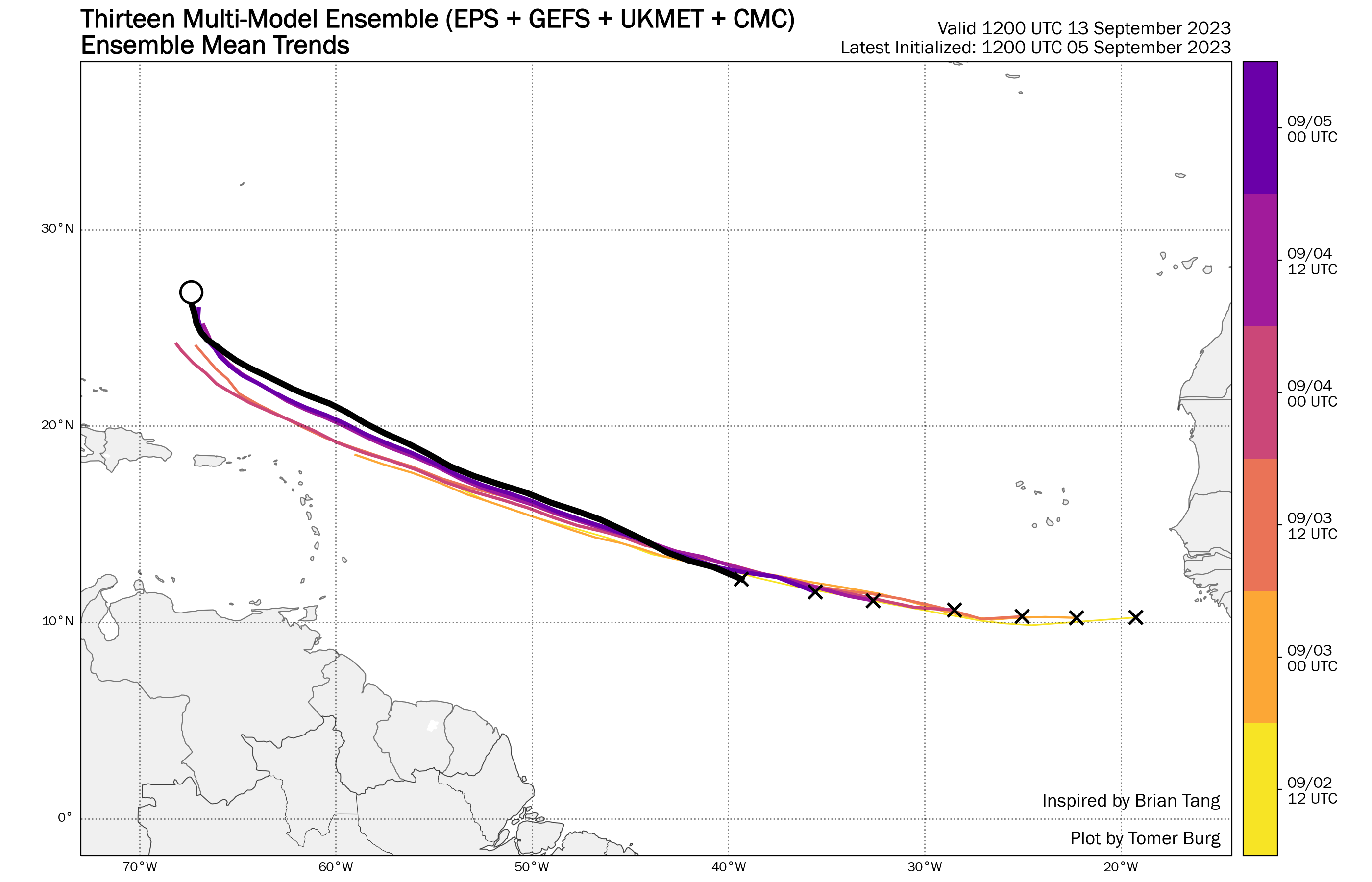
These are all the MMC ensemble center positions over time. Confidence is lower out at day 6 and 7.

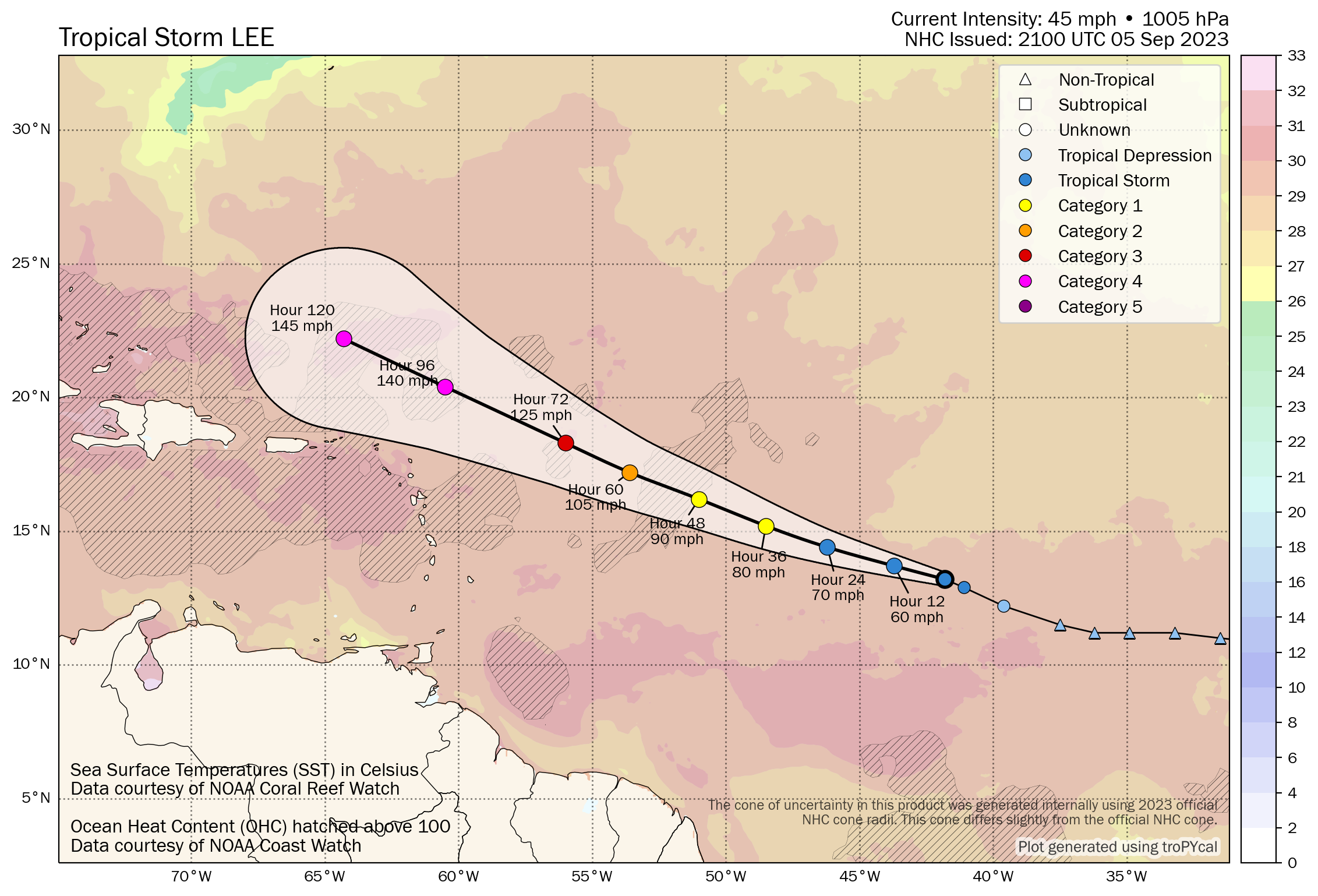
Here is the official NHC Track and Cone, showing average forecast errors of where the center might be at each time frame. This graphic also shows the very warm water which the storm will be traversing, with areas of very high oceanic heat content hatched.
It is too early to tell if Lee will be a threat to the U.S. East Coast, but that potential is there. Folks in the Leewards and Puerto Rico should pay close attention to the latest forecasts.
TCPAT3
BULLETIN
Tropical Storm Lee Advisory Number 2
NWS National Hurricane Center Miami FL AL132023
500 PM AST Tue Sep 05 2023
…TROPICAL STORM LEE EXPECTED TO RAPIDLY INTENSIFY INTO AN
EXTREMELY DANGEROUS HURRICANE BY THE WEEKEND…
SUMMARY OF 500 PM AST…2100 UTC…INFORMATION
———————————————-
LOCATION…13.2N 41.8W
ABOUT 1315 MI…2115 KM E OF THE LESSER ANTILLES
MAXIMUM SUSTAINED WINDS…45 MPH…75 KM/H
PRESENT MOVEMENT…WNW OR 290 DEGREES AT 16 MPH…26 KM/H
MINIMUM CENTRAL PRESSURE…1005 MB…29.68 INCHES
WATCHES AND WARNINGS
——————–
None.
Interests in the Leeward Islands should monitor the progress of
this system.
DISCUSSION AND OUTLOOK
———————-
At 500 PM AST (2100 UTC), the center of Tropical Storm Lee was
located near latitude 13.2 North, longitude 41.8 West. Lee is moving
toward the west-northwest near 16 mph (26 km/h), and this motion is
expected to continue for the next few days with a slight reduction
in forward speed.
Maximum sustained winds have increased to near 45 mph (75 km/h)
with higher gusts. Lee is forecast to be a hurricane within a couple
of days and will likely become a major hurricane by Friday.
Tropical-storm-force winds extend outward up to 70 miles (110 km)
from the center.
The estimated minimum central pressure is 1005 mb (29.68 inches).
HAZARDS AFFECTING LAND
———————-
None.
Key messages for Lee can be found in the Tropical Cyclone
Discussion under AWIPS header MIATCDAT3 and WMO header WTNT43 KNHC.
NEXT ADVISORY
————-
Next complete advisory at 1100 PM AST.
Forecaster Blake
About the Author (Author Profile)
Bill Murray is the President of The Weather Factory. He is the site's official weather historian and a weekend forecaster. He also anchors the site's severe weather coverage. Bill Murray is the proud holder of National Weather Association Digital Seal #0001 @wxhistorianSubscribe
If you enjoyed this article, subscribe to receive more just like it.


