Sunday Weather Briefing: A Dry Week with Even Temperatures
Saturday started off mostly cloudy across Alabama, but the thicker clouds gradually moved eastward during the afternoon. Showers and storms were able to form in the humid, warm air ahead of an approaching upper trough. The storms led to a delay at the UAB-Louisiana game at Protective Stadium in downtown Birmingham. There was also some flooding in the downtown area. High temperatures were all over the place yesterday, with afternoon readings hanging in the 70s over eastern sections. Highs included 75F at Anniston and Gadsden, 82F at Birmingham, and 88F at Tuscaloosa.
MAPPING OUT THE WEATHER: Low pressure is moving out of East Central Alabama into Georgia this morning with a frontal system trailing back to the southwest. The main cold front is located back in Missouri and that front will push through Alabama tonight, bringing some drier and cooler air to the state.
FOR YOUR SUNDAY: Low clouds and fog formed in the wake of the Saturday evening storms, but skies will clear pretty quickly as we go through the day. Highs this afternoon will range between 79-82F across the Tennessee Valley, 83-86F across North Central Alabama, with highs in the upper 80s over South Central Alabama. The mercury will settle into the 50s over the northern half of the area, with upper 50s and lower 60s over South Central Alabama.
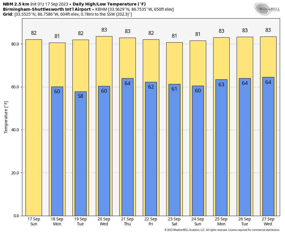
HIGH PRESSURE DOMINATES THE WEEK: Sprawling high pressure will be centered over Arkansas Monday, near Louisville Tuesday, over Central Pennsylvania Wednesday, Albany, NY Thursday, and New York City by Friday. While the center will be shifting around, the ridge will keep a protective lid on our weather in Alabama and the Deep South through the work week and into the weekend. Highs all week will be in the upper 70s to middle 80s. Overnight lows will be in the upper 50s to lower 60s.
WEEKEND OUTLOOK: The weekend look dry and warm, with highs in the 80s and lows in the upper 50s and lower 60s.
VOODOO TERRITORY: We may not see rain until early to midweek in the Week Two period. The GFS develops a tropical low north of the Bahamas by the weekend and spins it into the South Carolina coastline Sunday night or Monday. Doesn’t look very strong. The GFS hints that there will be some tropical mischief in the Gulf around the 1st. That will be something to watch as well.
BEACHCAST: After rain and storms today, it will be a nice week along the beautiful beaches of Alabama and Northwest Florida. Highs will be in the upper 80s. Lows will be near 70F. Water temperatures are still in the middle 80s. The rip current risk looks low into midweek.
Click here to see the Beach Forecast Center page.
IN THE TROPICS: The Tropical Atlantic continues to be busy with three active storms.
POST TROPICAL STORM LEE is moving through the Gulf of St. Lawrence early this morning after making landfall Saturday afternoon near the western end of Nova Scotia with max sustained winds of 70 mph. Peak wind gusts in eastern Massachusetts included 62 mph at Chapin and Dennis, and 58 mph at the Nantucket Airport. Winds gusted to 51 mph at Bangor ME. Winds gusted to 80 mph at Grand Manan on the Maine Coast.
TROPICAL STORM MARGOT has been describing a loop over the North Atlantic about 450 miles west southwest of the Azores. Top winds are 40 mph. The storm is expected to loop back to the east over the next 36 hours, approaching the Azores by Thursday, most likely as a tropical depression by then.
TROPICAL STORM NIGEL was upgraded from tropical depression status last night, and is located about 1150 miles southeast of Bermuda this morning. The storm has top winds of 50 mph and is moving northwest at about 14 mph. It should become a hurricane by tomorrow morning. Nigel will become a powerful hurricane by Tuesday, and should pass about 450-475 miles east of Bermuda late Tuesday night as it recurves to the northeast.
ELSEWHERE, a tropical wave expected to move off the African coast this week is being tracked by the NHC and they give it a 30% chance of developing into a tropical cyclone. The GFS isn’t buying it. The Euro does develop a tropical storm by early in week two, trending it northwestward and missing the islands, but a strong ridge to the north could turn it back west. We will be watching.
NATIONALLY: Fairly tranquil conditions across much of the United States. Fire weather watches and warnings are in effect across the northern Rockies.
DANCING WITH THE STATS: A sign of the times on Saturday, with record morning lows at Myrtle Beach SC and Wilmington NC with 53F and 54F respectively. The 97F at Marathon, FL in the Keys was not only the warmest September 16th ever, it was their warmest September day ever as well. Their records only go back to 1960, but still impressive.
ADVERTISE WITH US: Deliver your message to a highly engaged audience by advertising on the AlabamaWX.com website. We have a lot of big plans for this year. Don’t miss out! We can customize a creative, flexible, and affordable package that will suit your organization’s needs. Contact me, Bill Murray, at (205) 687-0782 and let’s talk.
WEATHERBRAINS: This week, the panel will entertain John Schmidt, Lead Hydrologist at the Southeastern River Forecast Center. Check out the show at www.WeatherBrains.com. You can also subscribe on iTunes. You can watch the show live on our new YouTube channel for the show.You will be able to see the show on the James Spann 24×7 weather channel on cable or directly over the air on the dot 2 feed.
ON THIS DATE IN 1947: The most severe hurricane of the 1947 hurricane struck South Florida. It would be the first of two major hurricanes to strike the Sunshine State that year. Meteorologists at the Weather Bureau Forecast Office in Miami unofficially named the hurricane “George,” a practice begun by Pacific meteorologists to distinguish between typhoons. The one minute average wind at Hillsboro Light reached 155 mph, the highest measured in the storm and still the higest measured in Florida history. The lowest recorded pressure was 27.76 inches at Mayfield FL. The hurricane would go on to strike Louisiana. Follow my weather history tweets on Twitter. I am @wxhistorian at Twitter.com.
Category: Alabama's Weather, ALL POSTS, Tropical
About the Author (Author Profile)
Bill Murray is the President of The Weather Factory. He is the site's official weather historian and a weekend forecaster. He also anchors the site's severe weather coverage. Bill Murray is the proud holder of National Weather Association Digital Seal #0001 @wxhistorianSubscribe
If you enjoyed this article, subscribe to receive more just like it.


