Very Nice Going Into the Midday Hour; Will Feel Almost Summer-Like by Mid-Afternoon
A VERY NICE LATE SATURDAY MORNING
As of the 10 am roundup this morning, skies are sunny across the entire area and temperatures only in the lower 70s to the lower 80s at this point. The warm spot was Tuscaloosa at 80º, while Anniston and Talladega were tied as the cool spots at 73º. Birmingham was sitting at 78º.
WHAT TO EXPECT TODAY & TOMORROW
It will begin to feel like summertime once we make it into the mid-afternoon hours as highs will reach the upper 80s to the lower 90s across the area. Skies will be sunny, and no rain is expected anywhere across Central Alabama throughout the remainder of today and tonight. Some light fog may form in a few locations tonight, but we’ll mainly stay clear with lows in the mid 50s to the lower 60s.
Sunday will be a very close repeat of today’s weather, until we get into the latter part of the afternoon and evening hours. We’ll start off with sunny skies through the morning and into the early afternoon, but clouds will be on the increase from that point forward. No rain is expected, and afternoon highs will be in the mid 80s to the lower 90s.
THE LATEST ON TROPICAL STORM OPHELIA
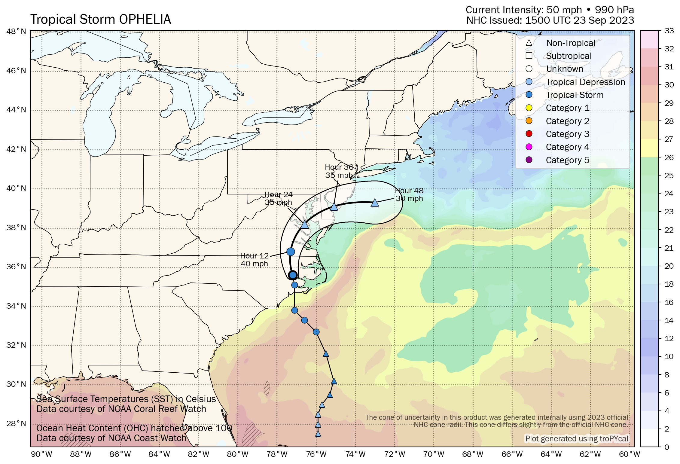
The center of Tropical Storm Ophelia was located near latitude 35.6 North, longitude 77.2 West, or around 75 miles north-northwest of Cape Lookout, North Carolina. Ophelia is moving toward the north near 13 mph (20 km/h). A continued northward motion is expected today, followed by a gradual turn toward the northeast by Sunday. On the forecast track, the center of Ophelia will continue moving across eastern North Carolina over southeastern Virginia over the remainder of today, and over the Delmarva Peninsula by tonight into Sunday. Maximum sustained winds are near 50 mph (85 km/h) with higher gusts. Further weakening is expected through the remainder of the weekend, and Ophelia is likely to become a post-tropical cyclone by Sunday. Tropical-storm-force winds extend outward up to 320 miles (520 km) from the center. The estimated minimum central pressure is 990 mb (29.24 inches).
Tropical storm conditions will continue along portions of the southeastern and mid-Atlantic U.S. coasts within the Tropical Storm Warning area today. There is a danger of life-threatening storm surge inundation over portions of eastern North Carolina and southeastern Virginia, including Pamlico and Albemarle Sounds, the Neuse and Pamlico Rivers, the lower James River, and the lower Chesapeake Bay, where Storm Surge Warnings are in place. Heavy rainfall from Ophelia may produce locally considerable flash, and urban flooding impacts across portions of the Mid-Atlantic states from North Carolina to New Jersey through Sunday. Swells generated by this system will affect much of the U.S. east coast through the weekend, likely causing life-threatening surf and rip currents.
TD-17 FORMS THIS MORNING
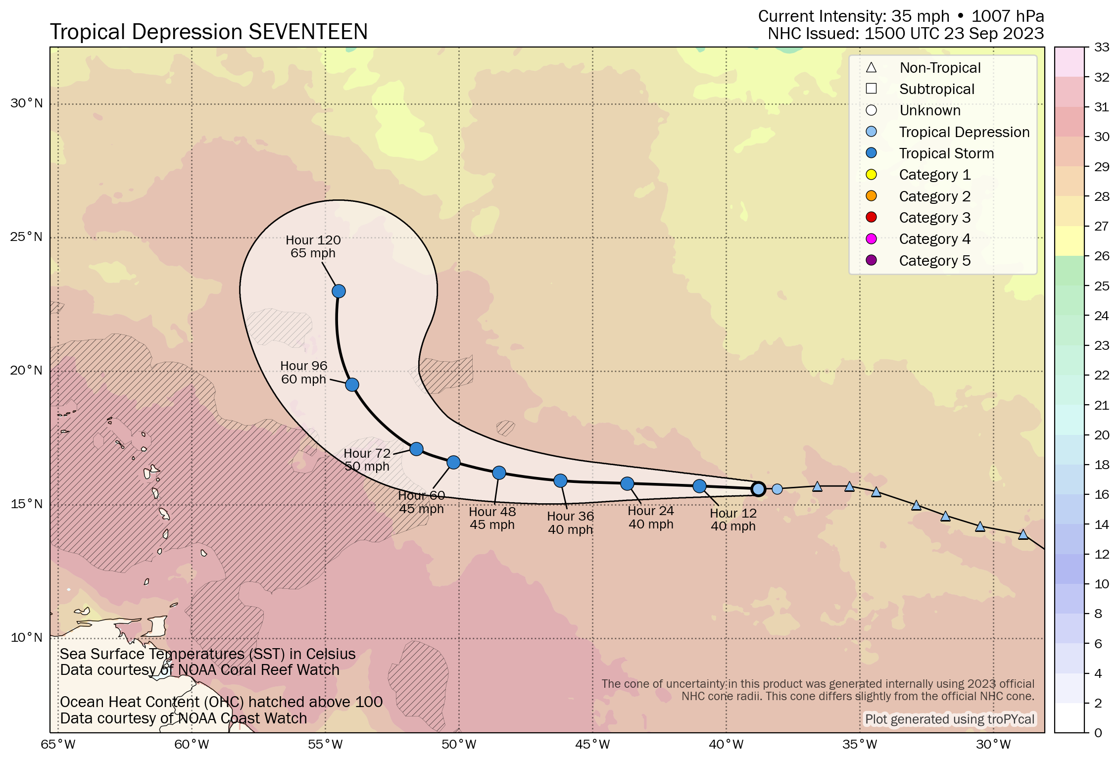
The center of Tropical Depression Seventeen was located near latitude 15.6 North, longitude 38.8 West, or around 985 miles west of the Cabo Verde Islands. The depression is moving toward the west near 15 mph (24 km/h) and this general motion with a slight decrease in forward speed is expected during the next few days. Satellite-derived wind data indicate that the maximum sustained winds are near 35 mph (55 km/h) with higher gusts. Very gradual strengthening is expected through early next week. The estimated minimum central pressure is 1007 mb (29.74 inches). The good news is that the models are showing this one curving away from any landmass and staying out over the open waters.
Category: Alabama's Weather, ALL POSTS, Tropical
About the Author (Author Profile)
Scott Martin is an operational meteorologist, professional graphic artist, musician, husband, and father. Not only is Scott a member of the National Weather Association, but he is also the Central Alabama Chapter of the NWA president. Scott is also the co-founder of Racecast Weather, which provides forecasts for many racing series across the USA. He also supplies forecasts for the BassMaster Elite Series events including the BassMaster Classic.Subscribe
If you enjoyed this article, subscribe to receive more just like it.


