Sunday Weather Briefing: Perfect Weather Warning for Monday and Tuesday
NO VIDEO THIS MORNING DUE TO TRAVEL
If you are a frequent readers of the blog over the years, you know that I have always loved trains. That goes my to my childhood But my love affair with this engine begin in 1991. It was an early spring morning in Trussville, and I had the windows open. I awakened to the most beautiful and haunting sound I had ever heard. I asked someone in town what that had been. The Norfolk Southern steam train. It goes to Chattanooga two weekends a year. It will come back through this afternoon. I found out what time and made plans to be there to greet it.
Sure enough, around 6 p.m., it came back through. Standing near the tracks, hearing the drivers pumping, the steam hissing, and that mournful whistle blowing for the grade crossing. I was hooked.
I have ridden a few steam trains in my life. The beautiful Southern 1218, the Nickel Plate 765, and the Southern 630 from the Tennessee Valley Railroad Museum, but the 611 is my first love. And I am getting a chance to ride it today in the Shenandoah Valley of Virginia. We will depart from Goshen, Virginia with 611 on the lead and travel over to Staunton (pronounced STAN-ton, I am told, as the U is silent).
Diesels will be attached there and the train will be pulled back to Goshen for an afternoon run, which I hope to pace and get some good video as it comes into Staunton.
More on the historic 611 in a special AlabamaWX blog post.
CLOSER TO HOME: Alabama and much of the eastern United States has experienced a dramatic pattern change as the first real front of the autumn season has brought drier and much cooler air to the state. Temperatures early on this Sunday morning are generally in the lower and middle 40a with some 30s in the normally colder valleys of North and North Central Alabama. Those readings are some 15 degrees under our normal lows for this time of year. Under a cloudless sky this afternoon, readings will struggle to get out of the 60s, with 70s limited to areas from Tuscaloosa and Demopolis to Montgomery, Auburn, and points south. Lows tonight will be in the mid 40s areawide.
HIGH FIRE DANGER: The National Weather Service has issued Red Flag Warnings for much of South Central and South Alabama through this evening. The combination of dry conditions, low humidities, and brisk northerly winds have set the stage for high fire danger. The Alabama Forestry Commission has the state under Fire Alert and no burn permits are being issued. Anyone who does any outdoor burning is subject to prosecution. Don’t be that guy.
PERFECT WEATHER WARNING: High pressure is currently in control of weather at the surface across Alabama from its home base in Northeast Texas. This will set the stage for some fabulous fall weather on Monday and Tuesday. With low humidities, light winds, cloudless skies on Monday and partly cloudy skies on Tuesday, and temperatures in the upper 70s to near 80 degrees, both days will be perfect. Clouds will increase late in the day Tuesday as moisture from Pacific Hurricane Lidia moves in at upper levels. But things will remain dry. Lows Tuesday morning will be in the lower 50s, Wednesday morning lows will be in the upper 50s with the insulating cloud cover Tuesday night.
MIDWEEK MOISTURE: Three things will be in play by Wednesday…the moisture for Lidia overspreading the Southeast on southwesterly upper level winds, with a surface low trying to form along the Gulf Coast and strong low pressure beginning to form over the Southern Plains. This low will g on to become the first of the deep midwestern lows that we see every fall. If the Gulf low manages to develop, it will spread rain up into South Alabama as early as Wednesday afternoon. Otherwise, you will notice mostly cloudy skies and an increasing south and southeast breeze. Highs will be in the middle and upper 70s. The showers will be out of the state by early Thursday, it appears, but don’t be surprise if they stretch into Thursday. No real airmass regime change, so highs on Thursday will still be in the 70s.
FRIDAY INTO THE WEEKEND: The deep low moving through the Great Lakes will gather up all the dry air that it can find and send it our way by Friday behind a strong cold front. If it can scoop up some moisture from a second Gulf low, showers could return on Friday. Skies will clear quickly on Saturday and it will turn sharply cooler again. Saturday and Sunday highs will be in the 60s again. Lows Sunday morning will be in the 40s, with a few 30s in the normally colder locations.
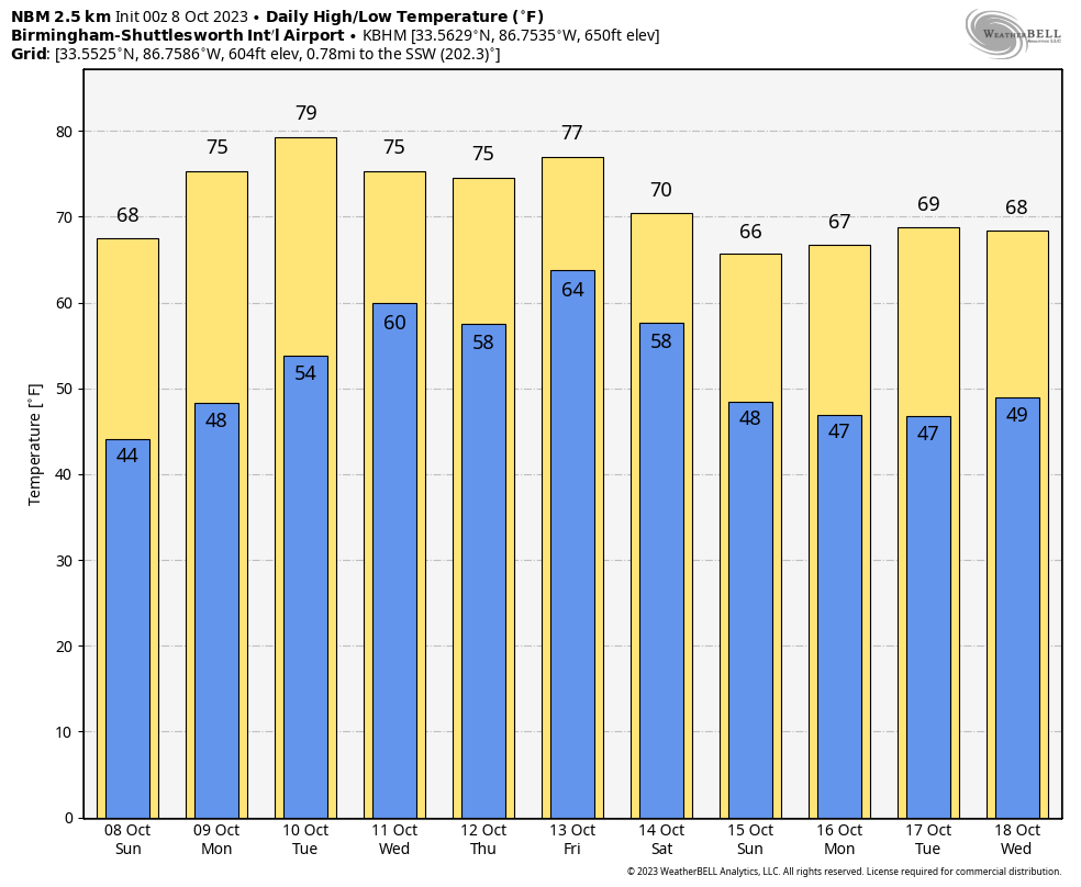
VOODOO TERRITORY: The week two periods will be dominated by a big East Coast upper level low, keeping us in a cool and dry northwesterly flow. This should keep our temperatures cooler than normal, with highs mostly in the 60s and lows in the 40s.
BEACHCAST: Nice through Tuesday along the beautiful beaches of Alabama and Northwest Florida with lots of sunshine and mild temperatures in the 70s during the day and 50s at night. Water temperatures are still nice, in the upper 70s. There is a low rip current risk through the early part of the week.
Click here to see the Beach Forecast Center page.
IN THE TROPICS: The Atlantic is quiet for now with the last advisory being written on Phillippe yesterday. The NHC does have a high probability that a tropical cyclone will form near the Cape Verde islands this week, but it too, will turn to the northeast and recurve as the late summer without a Bermuda high continues. In the Pacific, Hurricane Lidia will make landfall along the Mexican coast Tuesday afternoon.
ADVERTISE WITH US: Deliver your message to a highly engaged audience by advertising on the AlabamaWX.com website. We have a lot of big plans for this year. Don’t miss out! We can customize a creative, flexible, and affordable package that will suit your organization’s needs. Contact me, Bill Murray, at (205) 687-0782 and let’s talk.
WEATHERBRAINS: This week, the panel will entertain TV met Frank Waugh from Wichita. He has a great documentary about the first tornado ever captured on Doppler radar. It will be fun to talk about! Check out the show at www.WeatherBrains.com. You can also subscribe on iTunes. You can watch the show live on our new YouTube channel for the show.You will be able to see the show on the James Spann 24×7 weather channel on cable or directly over the air on the dot 2 feed.
ON THIS DATE IN 1837: The remnants of Racer’s Storm moved off the South Carolina coast and headed back into the open Atlantic where it intensified. Off Cape Hatteras, the paddle wheeler Home was sunk. There were only two life preservers onboard. The tragedy prompted Congress to make a law requiring all American boats to have one life preserver onboard for every passenger, a law that is still in effect today. Follow my weather history tweets on Twitter. I am @wxhistorian at Twitter.com.
Category: Alabama's Weather, ALL POSTS, Tropical
About the Author (Author Profile)
Bill Murray is the President of The Weather Factory. He is the site's official weather historian and a weekend forecaster. He also anchors the site's severe weather coverage. Bill Murray is the proud holder of National Weather Association Digital Seal #0001 @wxhistorianSubscribe
If you enjoyed this article, subscribe to receive more just like it.


