Sunday Weather Briefing: Sharply Colder This Week
NO VIDEO TODAY DUE TO TRAVEL
Greetings from the beautiful beaches of Alabama and Northwest Florida. The weather has been spectacular this final weekend in October, with the sunshine of June, the temperatures of late September, the water temperatures of April, and the crowds of January. Headed out for a little beach time…
FOR YOUR SUNDAY: Everyone is starting off in the upper 50s this morning under mostly sunny skies. Skies will stay sunny, and temperatures by afternoon will warm into the upper 70s to lower 80s.
ON THE WEATHER MAPS: We have a Titanic bathe between a stubborn ridge of high pressure located along the southeastern Atlantic coast and a powerful cold front. The front stretches from Waco to Texarkana to Memphis to Louisville this morning. It is 70 degrees this morning in Texarkana, while in McAlester, Oklahoma, just 145 miles away, it is down to 43F. Go further into the colder air and you will reach freezing at Shattuck, OK. The timetable for the front is as follows:
…Northwest Corner of Alabama: 2 p.m. today
…I-59…6 a.m. Monday
…Dothan…6 p.m. Monday
The front will be accompanied by a few showers. Temperatures will be falling behind the front, and by afternoon, readings will be in the 50s over Northwest Alabama with lower 80s over southeastern sections. Skies will be mostly cloudy along with that chance of showers. And it will be breezy.
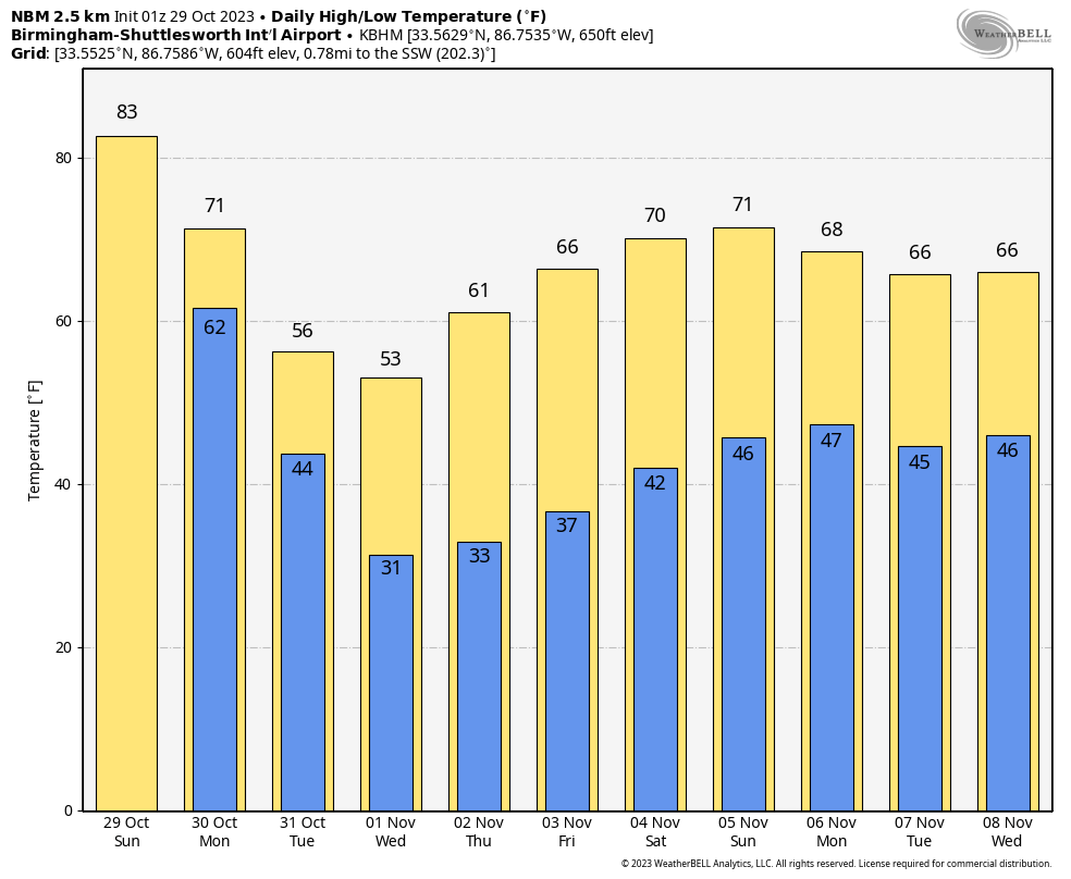
COLDER FOR HALLOWEEN: Temperatures Tuesday morning will be in the 30s Northwest, 40s in the I-59 Corridor, and lower 50s Southeast. Skies will be mostly cloudy and it will be breezy.
TRICK OR TREAT FORECAST: Skies will be clearing Tuesday evening, and it will be chilly. Temperatures will be falling through the lower 50s into the 40s as the ghosts and goblins hit the sidewalks.
MIDWEEK AND BEYOND: Ridging begins to rebuild over the southeast on Wednesday, but we’ll remain cool and breezy with plenty of sunshine. Highs in the 50s. Temperatures will begin to moderate as we’ll begin to see a shift in our winds out of the east on Thursday. We’ll have mostly sunny skies with highs in the upper 50s to the mid 60s. At the end of the forecast period on Friday, we’ll be a little warmer with mostly sunny skies. Highs in the mid to upper 60s.
WEEKEND OUTLOOK: Ridging will continue into and through the weekend, with sunny skies Saturday and partly cloudy skies on Sunday. The weekend will be dry. Highs will be near 70F. Lows will be in the 40s.
VOODOO TERRITORY: Another front will pass through Sunday night into early Monday, heralding another period of cool weather for us. The GFS hints at a big hurricane coming out of the western Caribbean, potentially into South Florida. It is too early to tell if it will even form, or if it does, where it will go.
BEACHCAST: As I reported earlier, the weather along the coast has been just wonderful. That will continue for the foreseeable future, but with a cool down starting tomorrow night behind our cold front. There could be a few clouds early this morning, but mostly sunny conditions will prevail the remainder of the week. Highs will be near 80F today and tomorrow, near 70F on Tuesday, and working their way back toward the 70s from the 60s the remainder of the week. Lows that have been in the upper 60s will fall back into the 50s Monday night, and 40s for the remainder of the week. Water temperatures are still in the lower 70s, and that high rip current risk has abated. Still, single red flags are flying this morning along the beaches, so be careful if you venture into the water.
Click here to see the Beach Forecast Center page.
IN THE TROPICS: A regenerated Tropical Storm Tammy is about 600 miles east of Bermuda, moving out over open waters. It is expected to gradually lose strength despite moving over some warmer waters. Shear and drier air is taking its toll. It will turn back to the west early in the week ahead, but it will just be wandering in the wilderness, and will turn northeast ahead of a big front by the first of November.
ELSEWHERE: A surface low developed yesterday northeast of the Dominican Republic. The GFS develops this into a tropical depression and possibly a tropical storm early in the week. On deck: Vince.
AND THERE’S MORE: Tropical cyclone development is possible in the Caribbean this week. The Caribbean is currently calm, but there is potential for a low-pressure system to develop in its western half next week. If one does form, it might be drawn northwards, sheared by a trough near the US East Coast, or possibly strengthen if it turns back to the western Caribbean. Environmental conditions next week could be conducive for development if the disturbed weather arises. The western and central Caribbean are regions to monitor for tropical development at this time of year, and it is too early for those in the central and western Caribbean to let their guard down with regard to possible tropical system formation.
DANCING WITH THE STATS: 20F at Billings MT on Friday was a record cold high for the date. There were several of those across the northern Rockies. The low of 9F Friday morning was a record low temperatures.
ADVERTISE WITH US: Deliver your message to a highly engaged audience by advertising on the AlabamaWX.com website. We have a lot of big plans for this year. Don’t miss out! We can customize a creative, flexible, and affordable package that will suit your organization’s needs. Contact me, Bill Murray, at (205) 687-0782 and let’s talk.
WEATHERBRAINS: This week, the panel will entertain. Check out the show at www.WeatherBrains.com. You can also subscribe on iTunes. You can watch the show live on our new YouTube channel for the show.You will be able to see the show on the James Spann 24×7 weather channel on cable or directly over the air on the dot 2 feed.
ON THIS DATE IN 2012: For the first itme in its history, the National Hurricane Center included snow as a hazard in one of its advisories. Intermediate Advisory 25A for Hurricane Sandy issued at 2 p.m. EDT included the following paragraph:
SNOWFALL..SNOW ACCUMULATIONS OF 2 TO 3 FEET ARE EXPECTED IN THE MOUNTAINS OF WEST VIRGINIA…WITH LOCALLY HIGHER TOTALS TONIGHT THROUGH TUESDAY NIGHT. SNOWFALL OF 1 TO 2 FEET IS EXPECTED IN THE MOUNTAINS OF SOUTHWESTERN VIRGINIA TO THE KENTUCKY BORDER… WITH 12 TO 18 INCHES OF SNOW POSSIBLE IN THE MOUNTAINS NEAR THE NORTH CAROLINA/TENNESSEE BORDER.
Follow my weather history tweets on Twitter. I am @wxhistorian at Twitter.com.
Category: Alabama's Weather, ALL POSTS, Tropical
About the Author (Author Profile)
Bill Murray is the President of The Weather Factory. He is the site's official weather historian and a weekend forecaster. He also anchors the site's severe weather coverage. Bill Murray is the proud holder of National Weather Association Digital Seal #0001 @wxhistorianSubscribe
If you enjoyed this article, subscribe to receive more just like it.


