Sunday Morning Weather Briefing: Heavy Rain for South Alabama This Week
Saturday was a dreary, gray day across Alabama. Highs across the state ranged from 54F at Albertville to 73F at Florala. Some patchy light rain moved across the Central part of the state through the day, but it was mostly out of the area by 6 p.m. Overnight lows were in the upper 40s over the Tennessee Valley and eastern sections of the state thanks to a cool easterly flow from Georgia. Patchy fog and low clouds were the rule.
ON THE WEATHER MAPS: Believe it or not, upper level ridging covers nearly all of the United States, including the Southeast. A cold, snaking stationary front extends across the entirety of the Central Gulf of Mexico, transecting Central Florida, and continuing to low pressure off the South Atlantic Coast. That low should crack the whip and propel the front southward over the Gulf, but only through early Monday, when new low pressure will form near Brownsville, Texas. Heavy rain will form across a wide area ahead of the low as it moves east northeast to a point off the Southwest Louisiana coast Tuesday morning. This rain will reach southern Alabama late Monday night into early Tuesday. By Thursday morning, the low will be south of Panama City, at which time it will begin accelerating to the east, crossing the Florida Peninsula and moving out into the Atlantic.
FOR YOUR SUNDAY: That patchy fog and low cloudiness will dominate this morning across North and Central Alabama. Clouds will diminish a bit during the day in most areas, except South Central Alabama, where they may hang tough most of the day. High temperatures across the area will range from 58-61 degrees over East Central Alabama in places like Eufaula and Auburn. Most other North and Central Alabama locations will be in the lower 60s. Only Mobile and the Gulf Coast will reach 70F. Lows tonight will be pretty much in the 40s areawide, except for areas along and south of US-80, including Demopolis and Montgomery.
NEW WORK WEEK: The day is dry on Monday areawide. With a little sunshine, high temperatures will be in the upper 60s across much of the area, except for East Central Alabama, which will be feeling the effects of that easterly wedge, keeping them in the lower 60s.
MID WEEK WINDOW: Rain will spread about up to the I-20 Corridor on Tuesday during the day on Tuesday, and with clouds and showers around, highs will be mostly in the upper 50s across Central Alabama as a stiff easterly wind sets up, with the wedge getting healthy reinforcement from the low to our south. North Alabama locations may get into the 60s. Wednesday will be similar, at least during the morning, with cloudy skies, showers along and south of I-20. The rain should be gone by Thursday, and with a little sunshine, high temperatures will be in the 60s again.
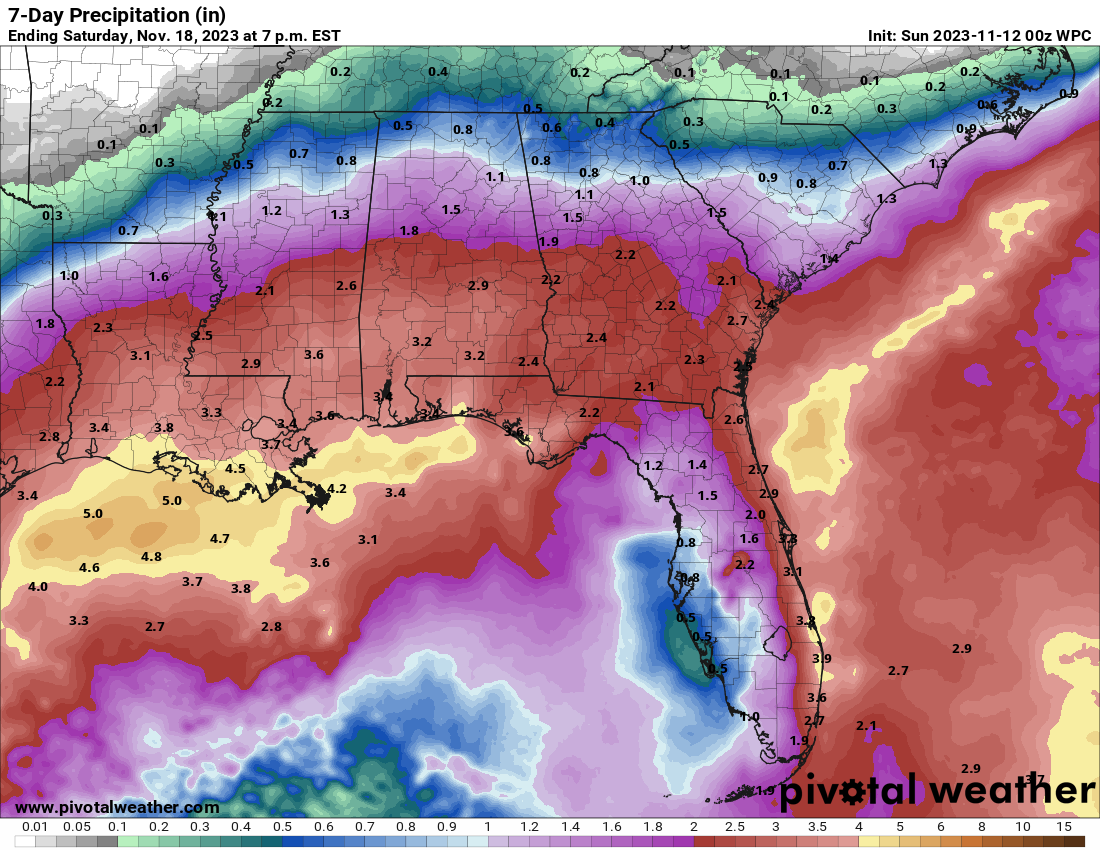
RAIN AMOUNTS: The low tracking over the Gulf will bring decent rains it appears to Alabama. Here are expected rainfall amounts according to QPF from the Weather Prediction Center.
WEEKEND OUTLOOK: Friday looks dry, even though a cold front will be sweeping into the state. A few showers could break out over Northeast Alabama. The weekend looks dry with highs in the 60s and lows in the 40s. Look for a brisk northwesterly wind, especially on Saturday.
NEXT RAIN CHANCES: Heading out into Voodoo Territory, rain returns fairly quickly, arriving by Monday night the 20th continuing into Tuesday the 21st. A full latitude trough develops over the eastern United States, bringing much colder and drier air into Alabama in time for the busiest travel day of the year, Wednesday. Wednesday highs may not get out of the 30s.
TURKEY DAY TRANQUILITY: Thanksgiving will be mostly sunny and cool, with highs remaining in the 40s all day after a morning with lows in the upper 20s and lower 30s.
WANT SOME REAL JUICY VOODOO? How about the possibility of snow and sleet in the Hill Country of Texas and the Dallas area on Black Friday?
IRON BOWL SNEAK PEEK: That disturbance that could raise some eyebrows in Texas on Black Friday will likely weaken as it passes over Alabama, giving us only clouds. Highs should be in the upper 50s to lower 60s with 40s in the morning.
BEACHCAST: Excessive rainfall is in the forecast for the beautiful beaches of Alabama and Northwest Florida, so not a great week. Today and Sunday, expect a low rip current risk with surf heights around 2 feet, and temperatures in the lower 70s. Water temperature is around a comfortable 70°F, but the UV index remains low. Winds will predominantly be from the northeast at around 10 mph. Monday will see an increase in surf height to 2 to 3 feet and a moderate rip current risk, accompanied by cloudy skies and chances of showers. This trend intensifies on Tuesday with a high rip current risk, surf heights reaching 3 to 5 feet, and persistent showers, as east winds strengthen to around 20 mph.
Click here to see the Beach Forecast Center page.
IN THE TROPICS: Low pressure might form over the western Caribbean early in the week, moving slowly to the northeast, perhaps becoming a tropical depression or tropical storm as it moves toward Jamaica and Hispaniola. The system will cross into the Atlantic and get torn about by the shear. Perhaps that will be the end of the 2022 Atlantic Hurricane Season.
NATIONALLY: Winter storm warnings were in effect overnight in the northern Cascades of northern Washington where 4 to 9 inches fell above 4500 feet.
DANCING WITH THE STATS: 91F at Brooksville FL was a new record for the date. Several other records were tied or broken across Florida, including Tampa, Fort Myers, and Miami.
ADVERTISE WITH US: Deliver your message to a highly engaged audience by advertising on the AlabamaWX.com website. We have a lot of big plans for this year. Don’t miss out! We can customize a creative, flexible, and affordable package that will suit your organization’s needs. Contact me, Bill Murray, at (205) 687-0782 and let’s talk.
WEATHERBRAINS: This week, the panel will entertain local meteorologist and all around nice lady, Ashley Gann! She has recently made some bold move in her career. Check out the show at www.WeatherBrains.com. You can also subscribe on iTunes. You can watch the show live at live.bigbrainsmedia.com or on James’ YouTube Channel You will be able to see the show on the James Spann 24×7 weather channel on cable or directly over the air on the dot 2 feed.
ON THIS DATE IN 1952: A blizzard led to a tragic train collision at the Wyoming/Utah border. The Union Pacific’s City of San Francisco ran two signals and crashed into the back of the City of Los Angeles in whiteout conditions, killing 17 and injuring 159. Follow my weather history tweets on Twitter. More in a special post on the blog at 9 a.m. I am @wxhistorian at Twitter.com.
Category: Alabama's Weather, ALL POSTS
About the Author (Author Profile)
Bill Murray is the President of The Weather Factory. He is the site's official weather historian and a weekend forecaster. He also anchors the site's severe weather coverage. Bill Murray is the proud holder of National Weather Association Digital Seal #0001 @wxhistorianSubscribe
If you enjoyed this article, subscribe to receive more just like it.


