Late Morning Update — Wintry Precipitation Continues to Be Likely on Monday/Tuesday
So, no change in the forecast for this weekend… For today, skies will be sunny, and we’ll need all the sunshine we can get to help us stay warm as highs will only be in the mid 40s to the lower 50s. We’ll go even colder on Sunday as a cold front starts to work into the area, bringing with it some clouds. Afternoon highs ranging from the mid 30s in the northwest to the upper 50s in the southeast.
Main points for the upcoming winter mischief for the first half of the upcoming work week.
- There is a potential for winter precipitation impacts on Monday
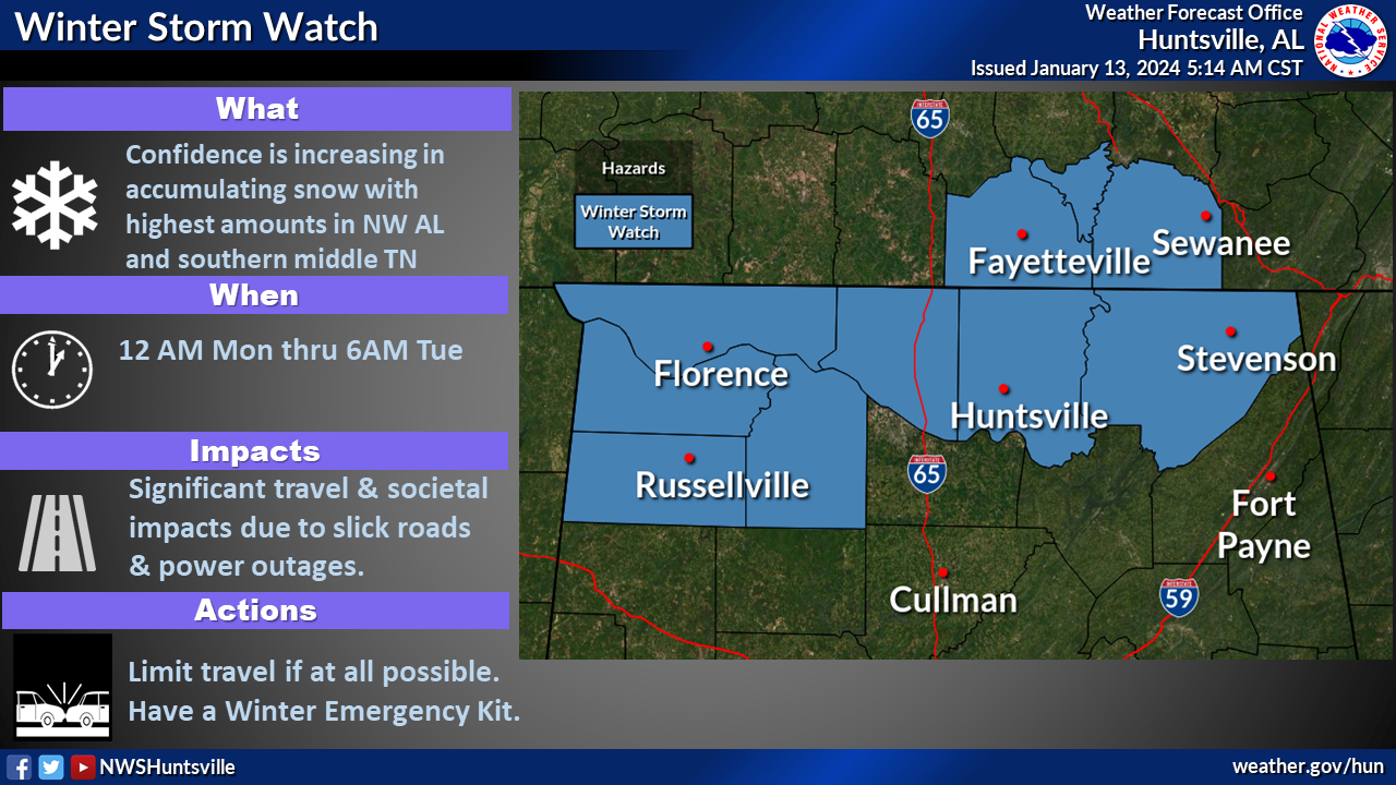
- Winter Storm Watch in effect for Colbert, Franklin, Jackson, Lauderdale, Lawrence, Limestone, and Madison counties in North Alabama from 12 am Monday until 6 am Tuesday.
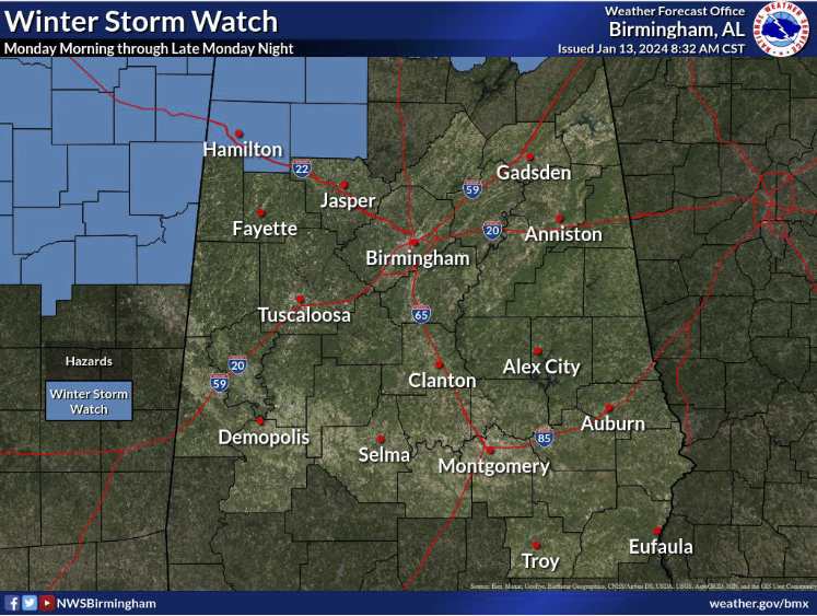
- Winter Storm Watch in effect for Marion and Winston counties in Central Alabama from 6 am Monday until 6 am Tuesday.
- Bitter cold conditions will last through the middle of the week
Latest from this morning’s NWS Birmingham briefing:
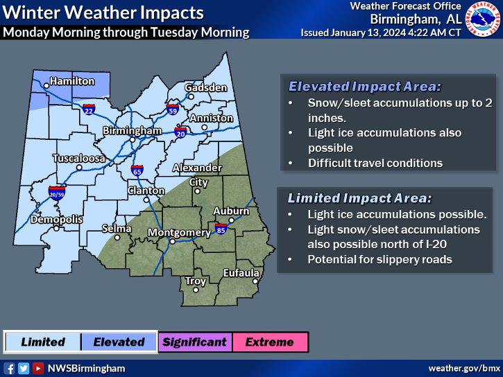
- A Winter Weather Advisory may be issued as early as late today for counties south of the Winter Weather Watch to as far south as Dallas, Chilton, Coosa, Clay, and Randolph counties, as light accumulations are possible with freezing rain, sleet, and snow fall will cause a good chance for slippery roads making travel difficult.
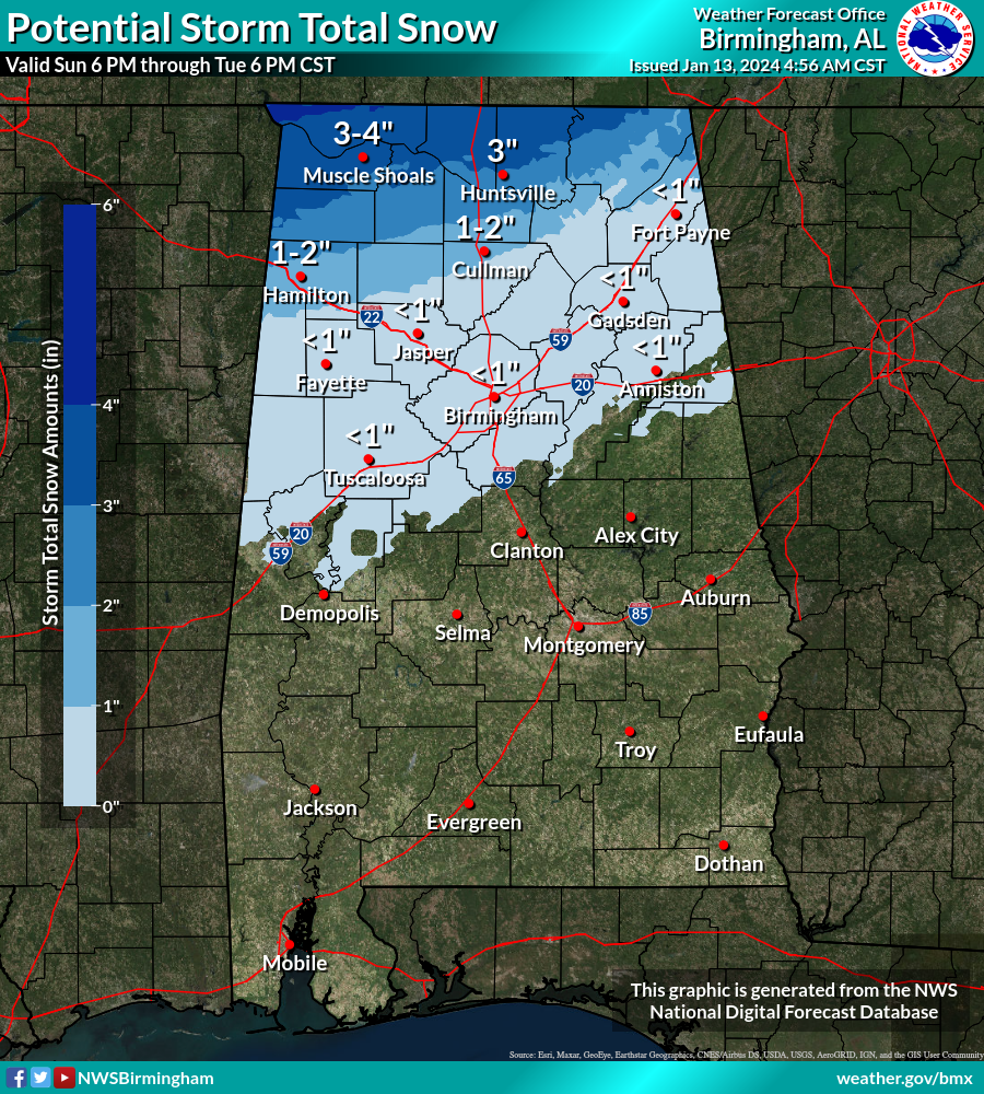
- More moderate impacts are expected over the Winter Storm Watch locations as travel disruptions may occur due to hazardous travel conditions. Limit travel if at all possible, and have a Winter Emergency Kit in your vehicle if you have to travel. Snowfall amounts for Marion and Winston counties may reach as high as 2 inches, while up to 4 inches will be possible for the rest of the watch area in North Alabama.
- Bitter cold temperatures will move in with and after this system as Wednesday morning lows will be in the single digits to the upper teens across all of North and Central Alabama, and highs on Wednesday afternoon will be below freezing for much of the area all the way down to I-85. Temperatures will begin to moderate on Thursday.
Category: Alabama's Weather, ALL POSTS, Winter Weather
About the Author (Author Profile)
Scott Martin is an operational meteorologist, professional graphic artist, musician, husband, and father. Not only is Scott a member of the National Weather Association, but he is also the Central Alabama Chapter of the NWA president. Scott is also the co-founder of Racecast Weather, which provides forecasts for many racing series across the USA. He also supplies forecasts for the BassMaster Elite Series events including the BassMaster Classic.Subscribe
If you enjoyed this article, subscribe to receive more just like it.


