Sunday Morning Weather Briefing: Winter Storm Headed for Alabama
You knew with all this cold air hanging around, we might have to deal with some wintry mischief. And that is the case. Lots to work through, so let’s get to it.
UPPER PATTERN: A big, broad trough covers much of the Lower 48 this morning with a really fast flow from the Rockies to the Ohio Valley. This fast flow will be contaminated with multiple shortwave disturbances that will swing across the Southeast starting tomorrow night through Tuesday morning. Throw in a very cold Arctic airmass that will be pushing into the area tomorrow night and Monday, and all sorts of issues will develop.
FIRST, FOR TODAY: We’re getting off to a chilly start tonight across the area with readings at or below freezing over the northern half of the area. It’s cold all the way to Mobile and the Gulf Coast with readings in the upper 30s all the way to the beaches. We’re starting off sunny this morning, but clouds will be increasing during the afternoon. Afternoon readings will be in the middle and upper 30s over the Tennessee valley, with lower and middle 40s elsewhere across the North and Central part of the state. The first of those disturbances will be getting ready to swing through starting late tomorrow night, and precipitation will start working into the northwest part of Alabama during the late evening. It will likely start out as snow for areas from Lamar, Winston, and Marion Counties into all of the Tennessee Valley.
WARNINGS AND ADVISORIES: The National Weather Service in Huntsville has issued a Winter Storm Warning for Colbert, Franklin, Jackson, Lauderdale, Lawrence, Limestone, and Madison Counties in North Alabama from midnight tonight until 6 am Tuesday. They are expecting heavy snow of 2-5 inches across these counties which will cause travel to become difficult. Wind chills near zero could be deadly if precautions aren’t taken.
They have upgraded their Winter Storm Watch to a Winter Weather Advisory from midnight tonight until 6 a.m. Tuesday for Marshall, Morgan, DeKalb, and Cullman Counties where they expect a wintry mix of snow, freezing rain and sleet to fall with accumulations of one inch of snow and ice accumulations up to one tenth of an inch. Morgan County could see two inches of snow along with the ice of up to one tenth of an inch. This will cause slippery road conditions.
The NWS in Birmingham has upgraded their watch to a Winter Storm Warning for Marion and Winston Counties from 6 p.m. tonight through 6 a.m. Tuesday. These two counties will experience up to two inches of snow and an ice accumulation of up to one tenth of an inch. This will create hazardous driving conditions starting this evening and continuing until Tuesday morning.
The NWS in Birmingham issued a Winter Weather Advisory for Lamar, Fayette, Walker, Blount, Etowah and Cherokee Counties from 6 a.m. Monday until 6 a.m. Tuesday for snow up to one inch accumulation and an ice accumulation to one tenth of an inch.
In the Winter Storm Warning areas, travel will become dangerous. If you must travel, keep an extra flashlight, food, and water in your vehicle in case of an emergency.
In the Winter Weather Advisory areas, travel is discouraged. If you must travel, slow down and use extra caution.
Wind chills across the entire area will drop into the single digits to near zero, so proper protection must be worn.
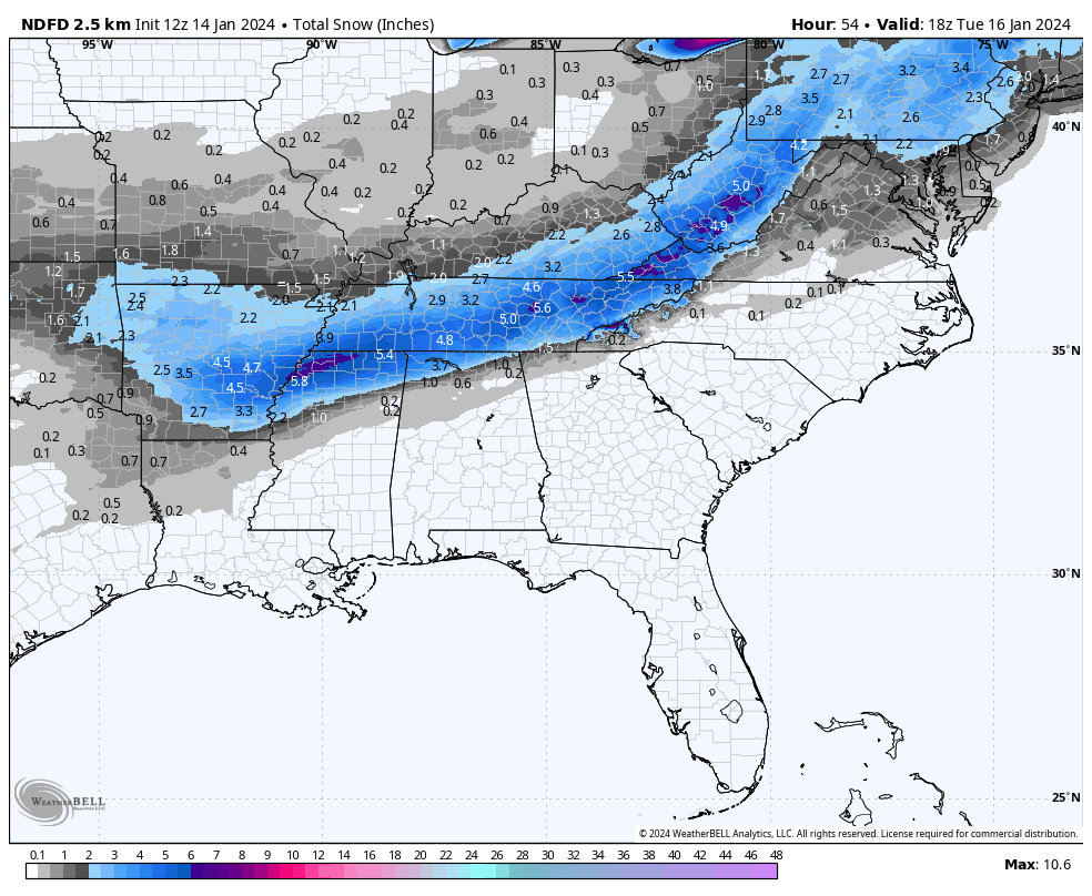
MAPPING IT OUT: Here is the expected snow accumulation map:
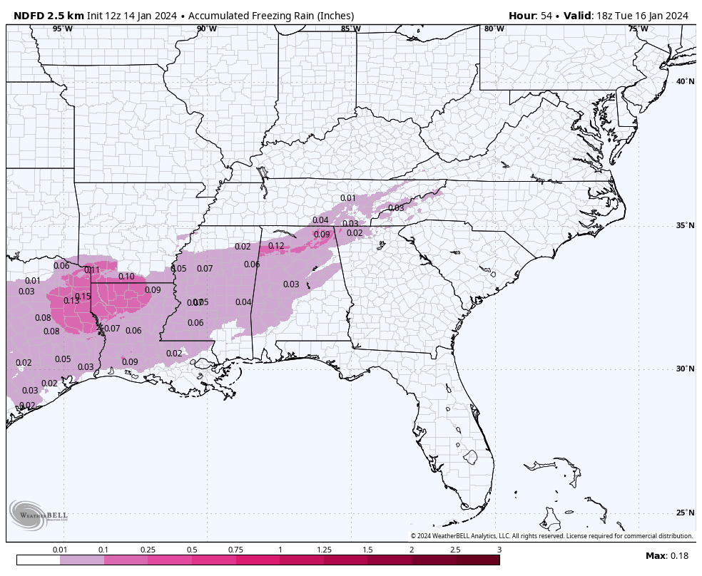
Here is the expected freezing rain accumulation by Tuesday evening:
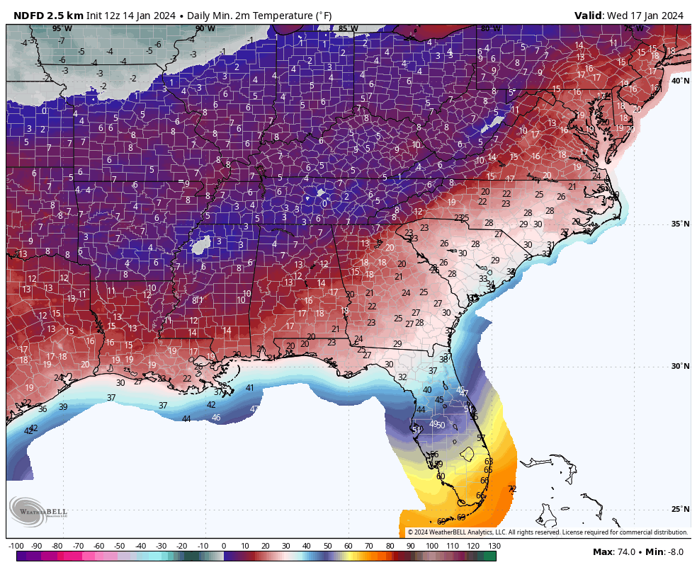
Low temperatures by Wednesday morning, the coldest night of the outbreak:
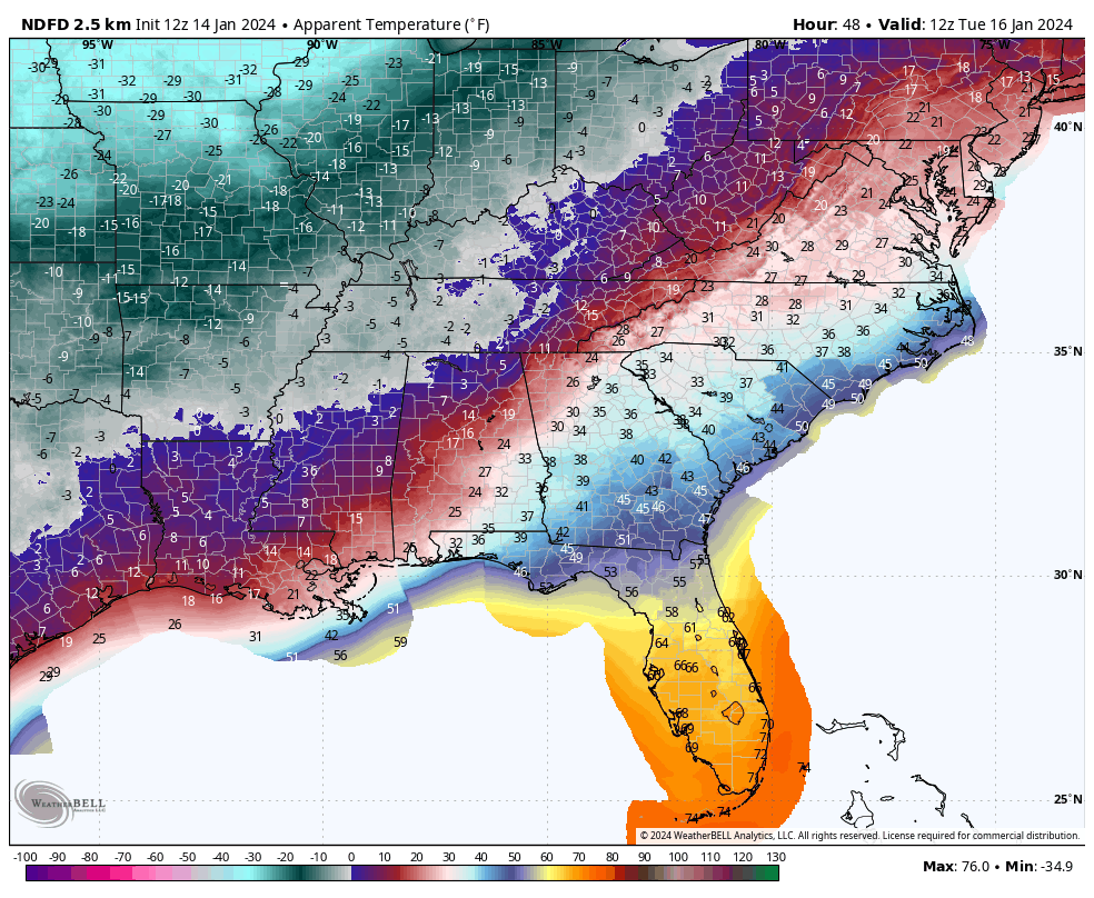
Wind chills Tuesday morning at 6 a.m.:
MONDAY: The leading edge of the Arctic airmass will be holding over Northwest Alabama during the day on Monday with highs to the south of it in the lower 40s. But by late afternoon, the cold air will start oozing southward and readings will go below freezing Monday night in the I-20 Corridor. It will continue to sink southward through the day on Tuesday. Meanwhile, another shortwave will roll across the area late Monday night. A mix of wintry precip with work into Central Alabama with this system, with slippery roads developing by early Tuesday morning. Additional winter weather advisories will be likely needed for areas as far south as Demopolis, Selma, Clanton, and Alex City. Freezing rain is of course the biggest threat to travel, and it looks like there could be a quarter of an inch accumulation across South Central Alabama in places from Washington and Clarke Counties northeast to Chilton County.
TERRIBLE TUESDAY: Tuesday will be miserable with a hard freeze across much of the area as the day begins and readings staying below freezing over the northern half of the area with wind chills below zero north of Birmingham. Winds will gust to 20 mph throughout the day. Wind chill advisories will undoubtedly be needed. The winds will decrease but will not lay down Tuesday night, so lows will not get as cold as they could, but readings will still be in the single digits down to Cullman and Jasper, with teens all the way to the Florida border. The entire state will experience a hard freeze Wednesday morning.
WEDNESDAY: Wednesday will be sunny and very cold with highs in still below freezing over the Tennessee valley, middle 30s over Central Alabama. The only piece of good news is that the winds will be relaxing. Wednesday night will be bitterly cold again with lows in the teens as far south as I-20, with lower 20s all the way to the Florida border again.
NEXT SYSTEM THURSDAY: A fast moving system till move our way by Thursday, with increasing clouds during the day and cloudy skies by dawn. Highs will be in the 40s and 50s. Showers will arrive by Thursday night, but with the warmer temperatures they will be of the liquid variety. The wintry precip will stay in Tennessee with this system.
FRIDAY INTO THE WEEKEND: Another piece of Arctic air will break off and head our way for the weekend. Skies will be clearing on Friday, with highs in the 30s northwest of I-59, with lower 40s to the southeast. We are back in the deep freeze by Saturday and Sunday with lows both mornings in the teens over much of the state. The good news is that it will be sunny both days.
WEEK TWO PERIOD: A big ridge develops over much of the nation in week two and that means a January Thaw. Look for another cold wave though around Saturday the 27th and Sunday the 28th.
BEACHCAST: The beautiful beaches of Alabama and Northwest Florida will not escape the cold this week. Our Arctic airmass will slide in on Tuesday. There could be a few showers during the day Tuesday, but it could change to freezing rain before ending Tuesday night. It remains to be seen if we will deal with travel problems. Water temperatures are in the upper 50s and there are no high rip current risks in the foreseeable future.
WEATHERBRAINS: This week, the panel will entertain. Check out the show at www.WeatherBrains.com. You can also subscribe on iTunes. You can watch the show live on our new YouTube channel for the show.You will be able to see the show on the James Spann 24×7 weather channel on cable or directly over the air on the dot 2 feed.
ON THIS DATE IN 2005: Five skiers were killed by a massive avalanche in the backcountry near Park City, Utah. The area had been marked off limits to skiers because of the threat of avalanches. The skiers were buried under thirty feet of snow. Two weeks of heavy, wet snow made for perfect avalanche conditions. Eleven people had already died in Utah avalanches during the season. The previous high for any winter was six. Follow my weather history tweets on Twitter. I am @wxhistorian at Twitter.com.
Category: Alabama's Weather, ALL POSTS, Winter Weather
About the Author (Author Profile)
Bill Murray is the President of The Weather Factory. He is the site's official weather historian and a weekend forecaster. He also anchors the site's severe weather coverage. Bill Murray is the proud holder of National Weather Association Digital Seal #0001 @wxhistorianSubscribe
If you enjoyed this article, subscribe to receive more just like it.


