Southwest/West Central Alabama SPC Outlook Upgraded to Slight (2/5), Rest of State Has Severe Weather Risk Also
Here is an update on the Alabama severe weather situation at 10:30 a.m.
It is cloudy across much of the state with some sunshine peeking through over North Central and West Central Alabama, particularly behind some heavy showers moving through the West Central part of the state.
There is some lightning from near Birmingham back through Bibb, Perry, and Marengo counties.
Stronger storms are back over southern Mississippi from south of I-20 in the Forest area back into Northeast Mississippi. Those storms are approaching I-59 in the Hattiesburg area.
Temperatures are in the 60s across all of North and Central Alabama with readings warming into the 70s down south. Dewpoints are high across the state, with lower 60s in North Alabama, middle 60s in Central and upper 60s doin South Alabama.
Instability is still low, with CAPE values just starting to exceed 500 joules over South Alabama. Values are higher back over southern Mississippi and southeastern Louisiana, with CAPEs between 500-15000 joules.
Bulk shear is increasing, averaging 45-55 knots in areas along and west of I-59. This will provide sufficient shear for organized storms, which we are seeing.
The best low level shear right now is over North Central Alabama along the warm front.
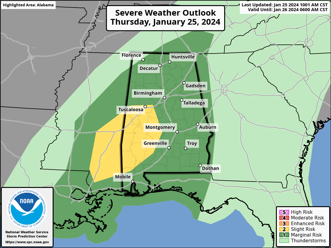
The new SPC Outlook just came out and has upgraded the severe weather risk over Southwest Alabama one level to Slight, (level 2/5). The remainder of Alabama remains under a Marginal Risk (1/5).
The line of storms will move into Alabama starting between 12-1 p.m. They will be capable of damaging wind gusts to 60 mph. There could be an isolated tornado or two, particularly in the slight risk area, in Counties like Sumter, Greene, Hale, Marengo, Perry, Tuscaloosa, Dallas, Wilcox, Clarke, Washington, Choctaw, and northern Mobile.
Category: Alabama's Weather, ALL POSTS, Severe Weather
About the Author (Author Profile)
Bill Murray is the President of The Weather Factory. He is the site's official weather historian and a weekend forecaster. He also anchors the site's severe weather coverage. Bill Murray is the proud holder of National Weather Association Digital Seal #0001 @wxhistorianSubscribe
If you enjoyed this article, subscribe to receive more just like it.


