Sunday Weather Briefing Video: Severe Weather Threat Today and Tomorrow
A threat of severe weather later today and tonight into Monday across parts of Alabama highlights this forecast package. Let’s take a deep dive into all the factors involved.
ON THE WEATHER MAPS THIS MORNING: A deep upper-level trough is located over the southwestern United States. A broad upper-level ridge is over the Caribbean up through Florida. At the surface, a stationary front extends from Virginia to near Asheville, North Carolina, into North Alabama, to a low over Central Mississippi, and across Louisiana to a surface low over the Texas Hill Country. The Texas low will become the dominant low as the low near Jackson, MS, moves to near Chattanooga. The Texas low will move to near Memphis by Monday morning, with a cold front arching into Alabama. A surface high east of the Bahamas will be pumping lots of war, moist air into Alabama and the Southeast.
FOR YOUR SUNDAY: The day is starting off cloudy across North and Central Alabama. Temperatures are in the 50s over the northern half of the state, with 60s over the southern half. Showers and thunderstorms are sinking southward across the state’s northern half early this morning. They have been loud with lightning and thunder but are below severe limits. They should begin to diminish through the morning hours and be done by noon. The rest of the day will be cloudy, warm, and humid. Afternoon readings will be in the upper 50s over Northwest Alabama, with lower 60s over North Alabama. South of US-278, readings will be in the upper 60s to lower 70s.
SEVERE WEATHER THREAT: We are watching storms now over North Central Texas that will be sliding east through the day. Those storms are3 rumbling through places like Mineola, Tyler, Gilmer, and Longview. They will roll through Shreveport around 11 a.m., and cross the Mississippi River around 2 p.m. Scattered showers and storms will break out across parts of Alabama by 2-3 p.m. These storms could become severe with damaging winds and the possibility of a couple of tornadoes. The biggest threat for a tornado may be over West Central Alabama starting around 3-4 p.m. through about 8 p.m. The main line of storms will traverse Central and North Alabama between 4-midnight, settling into a west-east orientation across the middle of the state. Additional storms will form across Mississippi and western Alabama during the overnight hours. By early Monday morning, another line of storms will form in the I-59 Corridor ahead of a cold front. Those storms will push southeastward into the afternoon. Some of them may become severe during the day. The rain and storms should be into Georgia by sunset, but there could be a few showers through the overnight hours, especially over the Tennessee Valley. Monday highs will be in the middle and upper 60s over the northwestern half of Alabama, with upper 60s to near 70F over southeastern portions of the area. Monday night lows will be in the middle and upper 30s north and Central and Southwest, with lower 40s over southeastern sections of Alabama.
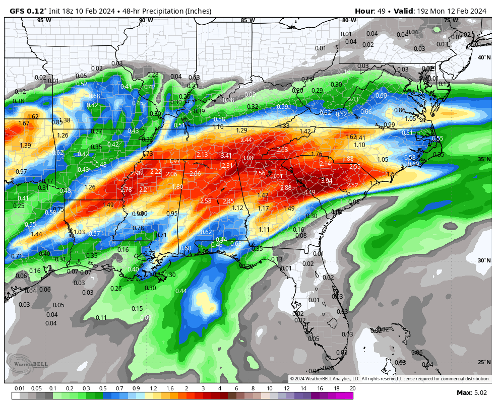
48 hour rainfall rates off the GFS
TUESDAY AND BEYOND: It’s an easy forecast from Tuesday through much of Friday as high pressure takes control of weather over the Southeast. Tuesday highs will be in the 50s, with 60s Wednesday, Thursday and Friday. Lows Wednesday and Thursday mornings will be in the 30s areawide with a light freeze Wednesday morning. Friday morning lows will be in the upper 30s Northeast, with lower and middle 40s elsewhere across North and Central Alabama.
NEXT WEATHERMAKER: Our next weather system will be a southern stream disturbance coming at us out of Mexico. We will be under another broad southwesterly flow aloft. Rain should reach southwestern Alabama by Friday evening. The rain will increase over South Alabama and it will spread northward during the day on Saturday, with another chilly, widespread rain. Highs on Saturday will be in the 50s over North and Central Alabama. The rain will end by Sunday morning, with quick clearing during the day. Sunday highs will be in the 50s as well.
VOODOO TERRITORY: The week two period will be dry through Friday again, much like this coming week. Rain will return on Saturday the 24th. But that system will be more progressive, with the rain exiting the area Saturday night. Weekend highs will be in the 60s with lows in the 50s.
BEACHCAST: Showers will be in the picture through Monday night along the beautiful beaches of Alabama and Northwest Florida. There could be strong to severe thunderstorms late tonight across the Alabama coast, spreading across the Northwest Florida coast Monday. Fog will be a problem along the beach through Monday afternoon as well. Highs today and Monday will be in the upper 60s to near 70s, with low tomorrow morning in the 60s. Highs for the rest of the week will fall back into the 60s, with lows in the 40s. The rip current risk will remain high through Tuesday with a onshore wind. Water temperatures are in the lower 60s.
Click here to see the Beach Forecast Center page.
NATIONAL NOTES: Interesting reading the Beach Hazards Statements from National Weather Service offices along the Washington, Oregon, and northern California coasts for sneaker waves. Sneaker waves are large waves that appear suddenly during a series of otherwise small waves. Far off storms and specific near shore conditions lead to their occurrence. The coast of the Pacific Northwest is particularly susceptible to sneaker waves because of its steep sea floor close to the coast.
DANCING WITH THE STATS: Record high temperatures were dropping like flies across eastern North Carolina and much of the eastern United States on Saturday afternoon. Raleigh reached 75F on Saturday, breaking their previous record of 73F set in 2009. They have a 78 year period of record there. State College, PA topped out at 59F, breaking their previous record of 57F. Rochester NY broke their record high for the second day in a row with a high of 56F. The old record was 55F. Portsmouth NH smashed their record high for February 10th, with a high of 59 degrees. Their previous record for the date was 52F. A honorable mention to New Orleans, which topped out at 77F. That was just three degrees shy of their record for the date of 80F.
NATIONAL NOTES (PART 2): The spring like warmth over the Northeast will be but a distant memory by early in the week as a nor’easter winds up along the East Coast. 8-15 inches of snow could fall from much of Pennsylvania across southern New York, Massachusetts, Connecticut and Rhode Island. Heavy rains and gusty winds will affect areas that don’t see the snow.
ADVERTISE WITH US: Deliver your message to a highly engaged audience by advertising on the AlabamaWX.com website. We have a lot of big plans for this year. Don’t miss out! We can customize a creative, flexible, and affordable package that will suit your organization’s needs. Contact me, Bill Murray, at billmurray at the weatherfactory.com and let’s talk.
WEATHERBRAINS: This week, the panel will entertain Cathy and Ralph Hufault. In 1958, a group of Boy Scouts who were missing in a surprise blizzard on Mount Baldy above Tucson, Arizona captivated the nation. Ralph was one of three Scouts who survived the incident. Three young men didn’t make it home. Ralph’s sister Cathy, who was 15 at the time, wrote a book about the tragedy. Check out the show at www.WeatherBrains.com. You can also subscribe on iTunes. You can watch the show live on our new YouTube channel for the show.You will be able to see the show on the James Spann 24×7 weather channel on cable or directly over the air on the dot 2 feed.
ON THIS DATE IN 2003: Residents of Central Illinois thought that the National Weather Service had gone crazy when their NOAA Weatheradio sirens sounded with severe thunderstorm warnings, even though it was snowing steadily. The NWS issued the warnings as a line of convective snowfall moved across the area. Many people were caught off guard, thinking that the warnings had been transmitted in error or were a test. The line did cause significant damage and even some injuries as it passed through with thundersnows and winds of 60 mph and greater. Follow my weather history tweets on Twitter. I am @wxhistorian at Twitter.com.
Category: Alabama's Weather, ALL POSTS, Severe Weather
About the Author (Author Profile)
Bill Murray is the President of The Weather Factory. He is the site's official weather historian and a weekend forecaster. He also anchors the site's severe weather coverage. Bill Murray is the proud holder of National Weather Association Digital Seal #0001 @wxhistorianSubscribe
If you enjoyed this article, subscribe to receive more just like it.


