Severe Thunderstorm Warning for Choctaw County Until 215 am
Thunderstorms are intensifying early this morning over West Central, Alabama, and southern Mississippi.
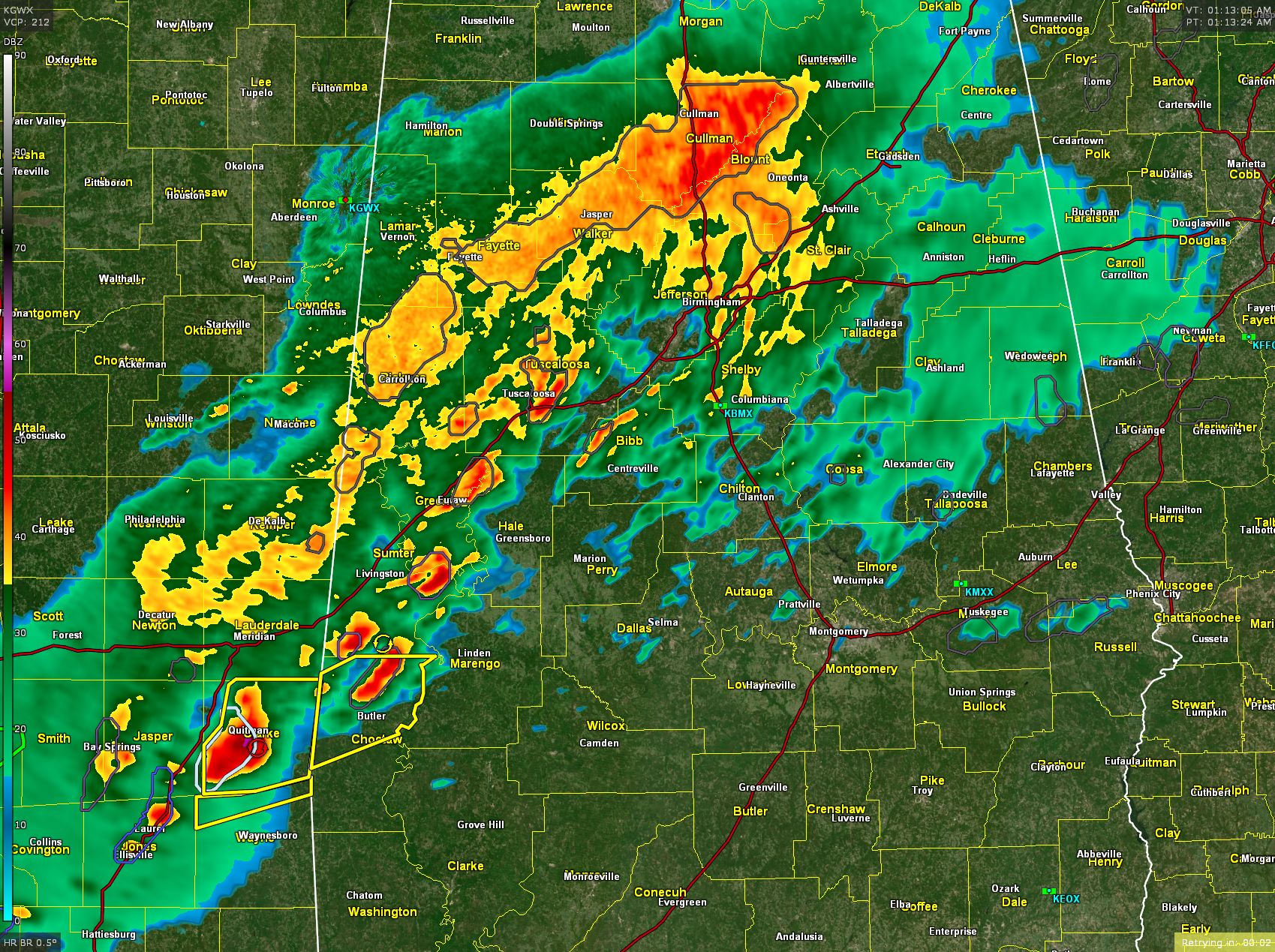
The strongest storm right now is approaching Quitman in Clarke County, Mississippi. It has lots of lightning in it. It will cross US 45 north of Shubuta. This will bring it into northern Butler, southern Sumter, and eventually Greene Hale and northern Marengo counties. The storm is moving to the northeast at 50 miles an hour. Radar indicates hail that is nearing 1 inch in diameter.
Hail that was 3/4 of an inch in diameter was reported earlier in your Sharon and Jones counties, Mississippi. Severe thunderstorm warnings remain in effect for eastern Jasper, Clark, and northern Wayne counties in East Central Mississippi.
Back to the south, heavier storms continue tonight along I 59 in the Laurel and Ellisville area. Also, near Bay Springs and other strong storms extend from Columbia and Marion counties back into southeastern Louisiana.
A very strong storm with a severe thunderstorm warning is occurring in Tangipahoa and Washington parishes in northeastern Louisiana. That storm will be approaching the Bogalusa area shortly.
Lots of heavy rain and some thunder is occurring across much of Central ALabama at this hour.
Heavy rainfall amounts of two to an additional 4 inches may fall overnight in this heavy thunderstorm activity as it moves northeast along a stalled boundary across Mississippi and Alabama. A flash flood watch remains in effect until 6 PM Monday for much of central Alabama.
Here is the warning…
The National Weather Service in Mobile has issued a
* Severe Thunderstorm Warning for…
Northern Choctaw County in southwestern Alabama…
* Until 215 AM CST.
* At 115 AM CST, a severe thunderstorm was located over De Soto, or
near Quitman, moving northeast at 55 mph.
HAZARD…60 mph wind gusts and quarter size hail.
SOURCE…Radar indicated.
IMPACT…Hail damage to vehicles is expected. Expect wind damage
to roofs, siding, and trees.
* Locations impacted include…
Butler, Lisman, and Pennington.
PRECAUTIONARY/PREPAREDNESS ACTIONS…
For your protection move to an interior room on the lowest floor of a
building.
Category: Alabama's Weather, ALL POSTS, Severe Weather
About the Author (Author Profile)
Bill Murray is the President of The Weather Factory. He is the site's official weather historian and a weekend forecaster. He also anchors the site's severe weather coverage. Bill Murray is the proud holder of National Weather Association Digital Seal #0001 @wxhistorianSubscribe
If you enjoyed this article, subscribe to receive more just like it.


