Sunday Weather Briefing Video: Warmer Weather Ahead
As we embark on the week ahead, we appear to be in for a delightfully tranquil stretch of weather. With clear skies, gentle breezes, and rising temperatures, smooth sailing lies ahead. So sit back, relax, and enjoy this forecasted period of serene conditions in the coming days!
WE WILL TAKE IT: Throughout the week ahead, North and Central Alabama will experience a mix of clear skies and occasional cloud cover. Temperatures gradually rise from cool to mild, with calm winds dominating most days. The region remains mostly dry, with only a slight chance of precipitation towards the end of the week, when a passing system brings increased cloud cover and a chance of rain showers. Let’s go day by day…
FOR YOUR SUNDAY: A shortwave will move over the area later in the day, though a dry atmospheric profile will limit its impact to persistent thick mid to high clouds. Strong surface high pressure will maintain its influence across the region, supporting low humidity values and north winds with speeds from 4-8 mph. High temperatures will struggle to reach 50 far north and in the higher terrain east, with readings in the mid-50s far southeast.
A MELLOW MONDAY: Expect clear skies as high-amplitude ridging builds over much of the Intermountain West and surface high-pressure centers over West Texas. Dry conditions will persist, with temperatures gradually warming. Winds will decrease overnight, leading to wind chill values from near 20 far north to the upper 20s far southeast.
BRIGHT TUESDAY: Continued clear skies are expected as strong surface high pressure remains centered over Central Texas, maintaining its influence across the region. Temperatures will continue to rise, supported by a Continental Polar airmass in place, with dew points generally from the teens to the twenties during the mid to late afternoon hours when vertical mixing is maximized. Winds will be out of the southwest at speeds from 4-8 mph.
WEDNESDAY WARMUP: Clear skies are likely to persist as surface high pressure maintains its influence across the Southern and Central Plains into the Tennessee Valley and Deep South Regions. A gradual warming trend is expected, with highs reaching the upper 60s to lower 70s by Wednesday. Light southerly winds are anticipated.
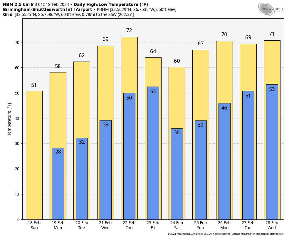
SHOWERS POSSIBLE THURSDAY: Clouds may start to increase as a fast-moving shortwave trough approaches the area, bringing a chance of showers to Alabama Thursday afternoon and into Thursday night. Rainfall amounts are likely to be minimal, around one-tenth of an inch or less. Temperatures will remain mild, with highs in the upper 60s to lower 70s.
FRIDAY FORECAST: Cloud cover is expected to persist with a chance of rain showers in the morning. Rainfall amounts are still likely to be minimal, with temperatures slightly cooler than previous days. Winds are anticipated to be light, generally from the northwest.
SUNNY SATURDAY: Skies are forecasted to clear once more, bringing back sunshine and mild temperatures. Light northwest winds are expected, contributing to a pleasant day overall. Highs will be in the middle and upper 50s.
BEACHCAST: Get ready for a mixed bag at the beach over the next few days! Tomorrow, conditions will improve as skies clear, with surf heights maintaining around 1-2 feet and temperatures in the mid-50s. The low rip current risk continues, so enjoy some sunshine and a stroll along the shore. Looking ahead, the weather stays pleasant with mostly sunny skies, calm surf conditions, and temperatures gradually warming into the upper 60s by midweek. Keep an eye out for updates on rip current risks and enjoy your time by the water! Those water temperatures are in the lower 60s.
Click here to see the Beach Forecast Center page.
NATIONALLY: As we look ahead to today and beyond, the West Coast remains the focal point for unsettled weather as energetic low pressure systems from the Pacific Ocean continue their march inland. Tomorrow, coastal areas of the Pacific Northwest and northern California can expect moderate to heavy rainfall, while the interior regions of the northwestern U.S. and northern Rockies will see accumulating mountain snow through Sunday. By Monday, a stronger low pressure system will sweep through, bringing the potential for heavy precipitation, particularly across California. Northern California and central coastal California face a risk of excessive rainfall, with significant snowfall forecasted for the Sierra Nevada. Meanwhile, a warming trend is on the horizon for the mid-section of the country, gradually spreading southward to Texas by Monday, following a period of colder than normal conditions. Across the eastern and southern U.S., conditions will clear out, with lake-effect snows diminishing by Sunday. In the Florida Peninsula, rain and thunderstorms will continue to expand through tonight, with a low pressure center developing along the Gulf of Mexico on Sunday, expected to bring several inches of rain and locally higher amounts.
ADVERTISE WITH US: Deliver your message to a highly engaged audience by advertising on the AlabamaWX.com website. We have a lot of big plans for this year. Don’t miss out! We can customize a creative, flexible, and affordable package that will suit your organization’s needs. Contact me, Bill Murray by email at billmurray at theweatherfactory.com, and let’s talk.
WEATHERBRAINS: This week, the panel will entertain journalist Andy McPhee, who has written an outstanding book about the Donora, PA smog event back in 1948. It provided the impetus for the Clean Air Act of 1970. Check out the show at www.WeatherBrains.com. You can also subscribe on iTunes. You can watch the show live on our new YouTube channel for the show.You will be able to see the show on the James Spann 24×7 weather channel on cable or directly over the air on the dot 2 feed.
ON THIS DATE IN 1847: The first rescue party reached the ill-fated Donner Party. Over half of the 81 California-bound pioneers perished during the ordeal, which started when the first snows struck in October of 1846.Follow my weather history tweets on Twitter. I am @wxhistorian at Twitter.com.
Category: Alabama's Weather, ALL POSTS
About the Author (Author Profile)
Bill Murray is the President of The Weather Factory. He is the site's official weather historian and a weekend forecaster. He also anchors the site's severe weather coverage. Bill Murray is the proud holder of National Weather Association Digital Seal #0001 @wxhistorianSubscribe
If you enjoyed this article, subscribe to receive more just like it.


