Severe Thunderstorm Warning for Parts of Colbert and Lauderdale Counties until 830 am
The possibility of a tornado can’t be ruled out with this storm that has good rotation.
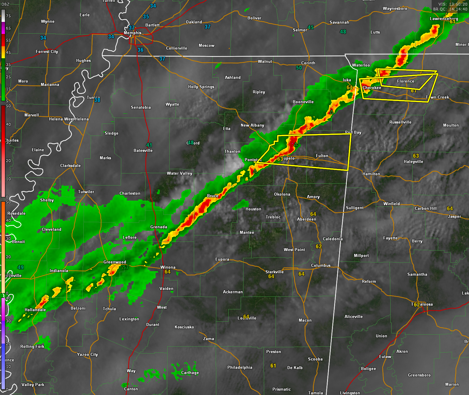
A line of storms is entering Northwest Alabama. There is another severe warned cell near Tupelo.
It will reach southern Franklin and Marion Counties within the hour. Strong winds and some hail are possible with that cell.
Strong storms will push across North and Central Alabama today. They are not expected to strengthen appreciably, but a few of the stronger storms could produce strong winds, hail, and possibly a brief tornado.
BULLETIN – IMMEDIATE BROADCAST REQUESTED
Severe Thunderstorm Warning
National Weather Service Huntsville AL
806 AM CST Wed Feb 28 2024
The National Weather Service in Huntsville Alabama has issued a
* Severe Thunderstorm Warning for…
Southern Lauderdale County in northwestern Alabama…
Central Colbert County in northwestern Alabama…
* Until 830 AM CST.
* At 806 AM CST, a severe thunderstorm was located over Cherokee, or
12 miles east of Iuka, moving east at 45 mph.
HAZARD…60 mph wind gusts.
SOURCE…Radar indicated.
IMPACT…Expect damage to roofs, siding, and trees.
* Locations impacted include…
Florence, Muscle Shoals, Sheffield, Tuscumbia, Killen, Cherokee,
St. Florian, Underwood-Petersville, Northwest Alabama Regional
Airport, and Oakland.
PRECAUTIONARY/PREPAREDNESS ACTIONS…
Remain alert for a possible tornado! Tornadoes can develop quickly
from severe thunderstorms. If you spot a tornado go at once into the
basement or small central room in a sturdy structure.
For your protection move to an interior room on the lowest floor of a
building.
An additional warning has been issued for the storm now near Petersville.
BULLETIN – IMMEDIATE BROADCAST REQUESTED
Severe Thunderstorm Warning
National Weather Service Huntsville AL
815 AM CST Wed Feb 28 2024
The National Weather Service in Huntsville Alabama has issued a
* Severe Thunderstorm Warning for…
Southeastern Lauderdale County in northwestern Alabama…
Central Colbert County in northwestern Alabama…
* Until 845 AM CST.
* At 812 AM CST, a severe thunderstorm was located over Cherokee, or
12 miles east of Iuka, moving east at 55 mph.
HAZARD…60 mph wind gusts.
SOURCE…Radar indicated. Trees were reported down at 8:05 AM CST
in the Riverton area.
IMPACT…Expect damage to roofs, siding, and trees.
* Locations impacted include…
Florence, Muscle Shoals, Sheffield, Tuscumbia, Killen, Cherokee,
Leighton, St. Florian, Northwest Alabama Regional Airport, and Mt
Hester.
PRECAUTIONARY/PREPAREDNESS ACTIONS…
For your protection move to an interior room on the lowest floor of a
building.
Category: Alabama's Weather, ALL POSTS, Severe Weather
About the Author (Author Profile)
Bill Murray is the President of The Weather Factory. He is the site's official weather historian and a weekend forecaster. He also anchors the site's severe weather coverage. Bill Murray is the proud holder of National Weather Association Digital Seal #0001 @wxhistorianSubscribe
If you enjoyed this article, subscribe to receive more just like it.


