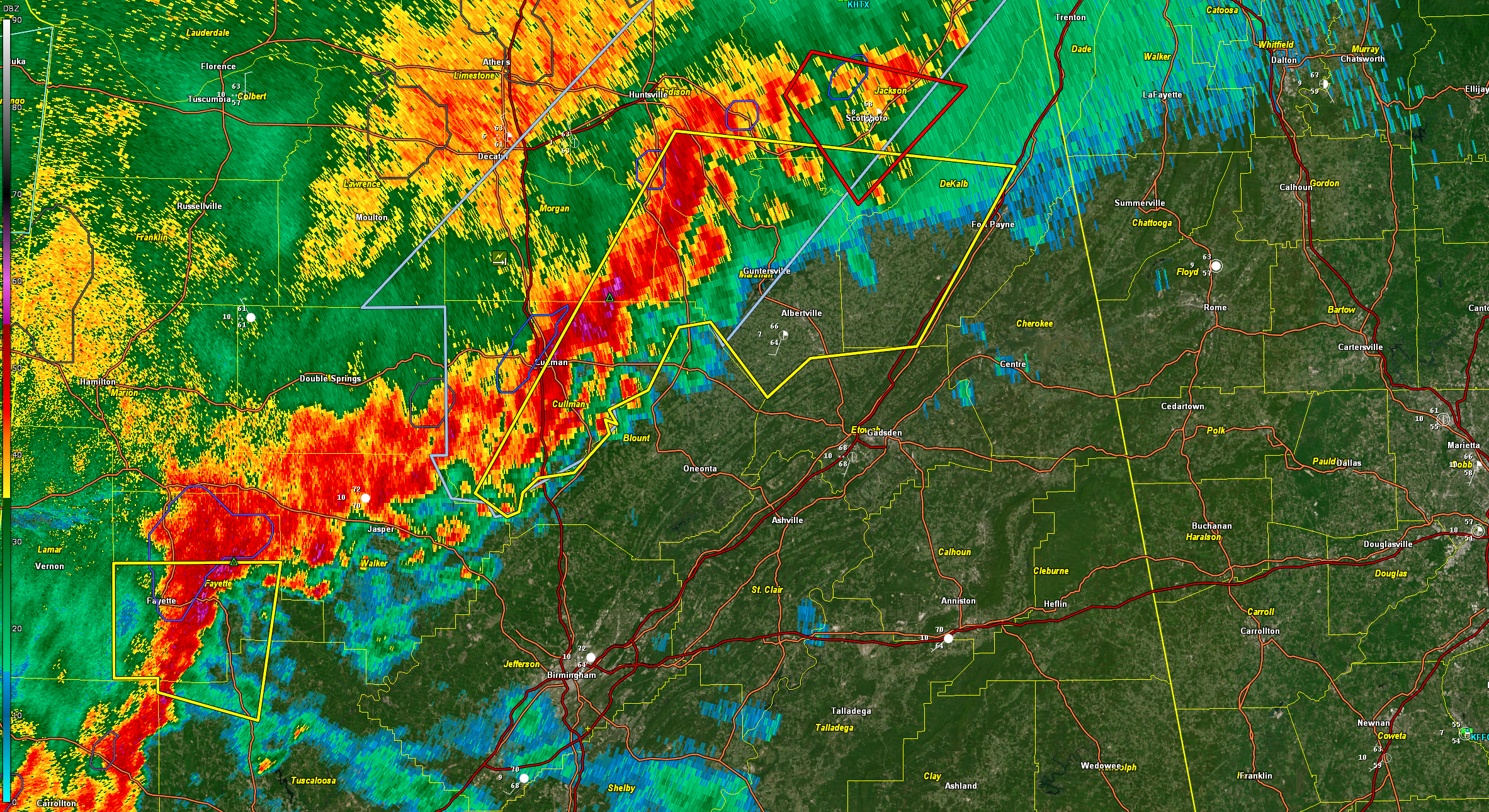
Severe Thunderstorm Warning for Parts of Blount, Etowah, and St. Clair Counties Until 745 am
BULLETIN – IMMEDIATE BROADCAST REQUESTED
Severe Thunderstorm Warning
National Weather Service Birmingham AL
638 AM CDT Fri Mar 15 2024
The National Weather Service in Birmingham has issued a
* Severe Thunderstorm Warning for…
Blount County in central Alabama…
Etowah County in northeastern Alabama…
Northern St. Clair County in central Alabama…
* Until 745 AM CDT.
* At 638 AM CDT, severe thunderstorms were located along a line
extending from near McLarty to Dallas, moving east at 40 mph.
HAZARD…60 mph wind gusts.
SOURCE…Radar indicated.
IMPACT…Expect damage to roofs, siding, and trees.
* Locations impacted include…
Gadsden, Rainbow City, Oneonta, Attalla, Springville, Blountsville,
Cleveland, Dallas, Ashville, Sardis City, Ragland, Locust Fork,
Steele, Altoona, Snead, Susan Moore, Walnut Grove, Reece City,
Allgood, and Fairview.
PRECAUTIONARY/PREPAREDNESS ACTIONS…
Remain alert for a possible tornado! Tornadoes can develop quickly
from severe thunderstorms. If you spot a tornado go at once into the
basement or small central room in a sturdy structure.
For your protection move to an interior room on the lowest floor of a
building.
&&
LAT…LON 3410 8630 3418 8619 3419 8611 3420 8610
3420 8584 3371 8618 3383 8673 3425 8645
TIME…MOT…LOC 1138Z 280DEG 33KT 3421 8642 3387 8665
TORNADO…POSSIBLE
HAIL THREAT…RADAR INDICATED
MAX HAIL SIZE…<.75 IN
WIND THREAT...RADAR INDICATED
MAX WIND GUST...60 MPH
$$
40/Sizemore
Category: Alabama's Weather, ALL POSTS, Severe Weather
About the Author (Author Profile)
Bill Murray is the President of The Weather Factory. He is the site's official weather historian and a weekend forecaster. He also anchors the site's severe weather coverage. Bill Murray is the proud holder of National Weather Association Digital Seal #0001 @wxhistorianSubscribe
If you enjoyed this article, subscribe to receive more just like it.


