Severe Thunderstorm Warning for Much of Shelby County
BULLETIN – IMMEDIATE BROADCAST REQUESTED
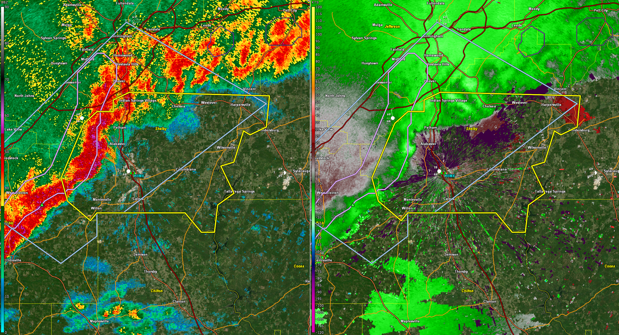
Severe Thunderstorm Warning
National Weather Service Birmingham AL
815 AM CDT Fri Mar 15 2024
The National Weather Service in Birmingham has issued a
* Severe Thunderstorm Warning for…
Shelby County in central Alabama…
* Until 915 AM CDT.
* At 815 AM CDT, a severe thunderstorm was located over Maylene, or
over Alabaster, moving east at 35 mph.
HAZARD…60 mph wind gusts and nickel size hail.
SOURCE…Radar indicated.
IMPACT…Expect damage to roofs, siding, and trees.
* Locations impacted include…
Hoover, Alabaster, Pelham, Helena, Calera, Chelsea, Montevallo,
Childersburg, Columbiana, Wilsonville, Indian Springs Village,
Vincent, Harpersville, Westover, Wilton, American Village, Oak
Mountain State Park, Maylene, Oak Mountain Amphitheater, and
Riverchase.
PRECAUTIONARY/PREPAREDNESS ACTIONS…
Remain alert for a possible tornado! Tornadoes can develop quickly
from severe thunderstorms. If you spot a tornado go at once into the
basement or small central room in a sturdy structure.
For your protection move to an interior room on the lowest floor of a
building.
&&
LAT…LON 3337 8635 3329 8636 3327 8641 3328 8643
3320 8646 3319 8650 3312 8646 3309 8651
3302 8652 3302 8656 3307 8661 3307 8688
3305 8690 3310 8697 3316 8699 3330 8692
3333 8688 3333 8683 3336 8683 3338 8678
TIME…MOT…LOC 1315Z 284DEG 32KT 3323 8686
TORNADO…POSSIBLE
HAIL THREAT…RADAR INDICATED
MAX HAIL SIZE…0.88 IN
WIND THREAT…RADAR INDICATED
MAX WIND GUST…60 MPH
Category: Alabama's Weather, ALL POSTS, Severe Weather
About the Author (Author Profile)
Bill Murray is the President of The Weather Factory. He is the site's official weather historian and a weekend forecaster. He also anchors the site's severe weather coverage. Bill Murray is the proud holder of National Weather Association Digital Seal #0001 @wxhistorianSubscribe
If you enjoyed this article, subscribe to receive more just like it.


