

Severe Thunderstorm Warning Now for Chilton and Autauga…Tornado Possible
The rotation has weakened…but could spin back up…
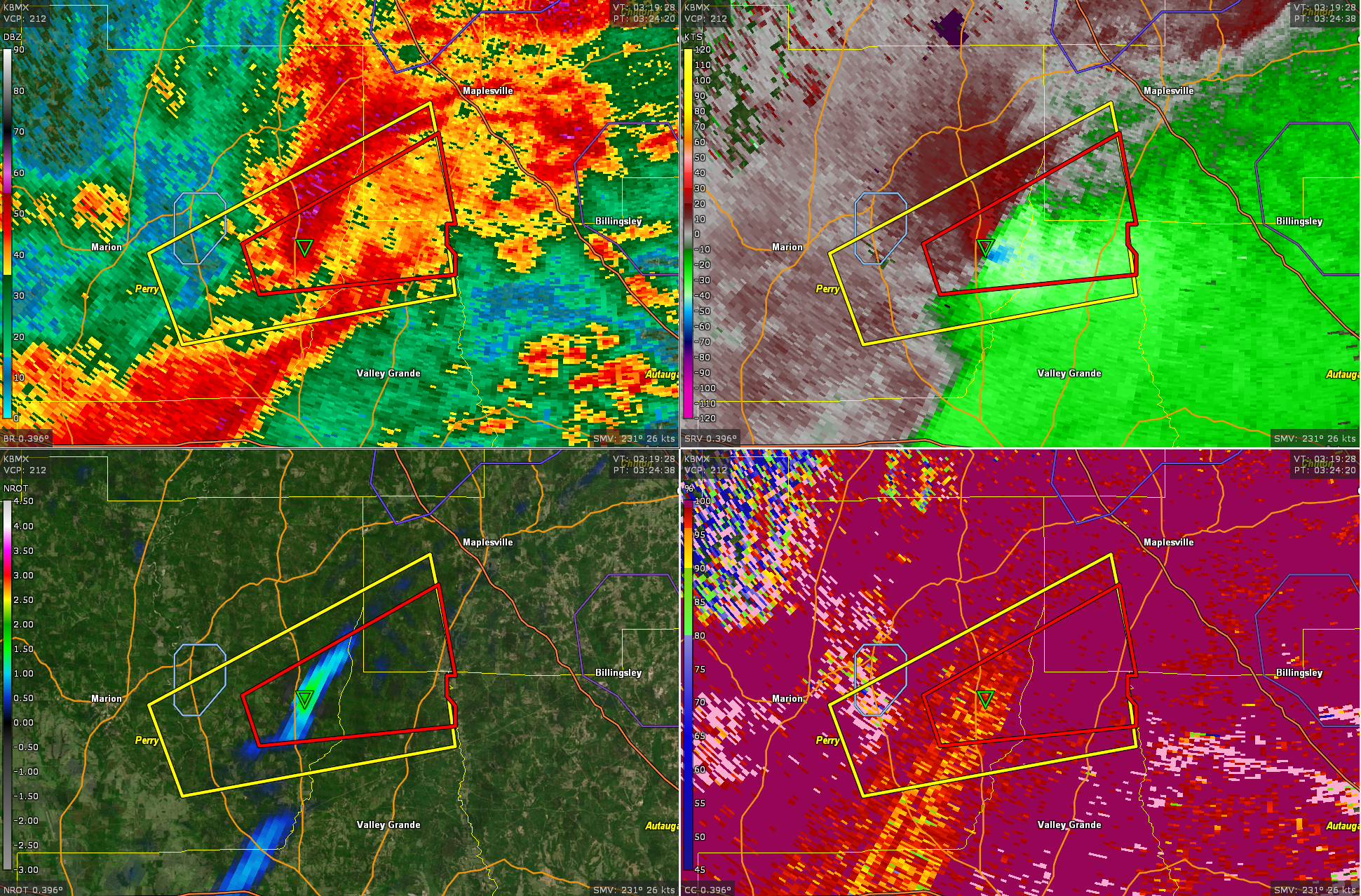
Definitely have had a tornado with this storm.
BULLETIN – IMMEDIATE BROADCAST REQUESTED
Severe Thunderstorm Warning
National Weather Service Birmingham AL
1037 PM CDT Tue Apr 2 2024
The National Weather Service in Birmingham has issued a
* Severe Thunderstorm Warning for…
Northwestern Autauga County in central Alabama…
Southwestern Chilton County in central Alabama…
* Until 1115 PM CDT.
* At 1037 PM CDT, a severe thunderstorm was located over Parnell, or
11 miles north of Valley Grande, moving east at 50 mph.
HAZARD…60 mph wind gusts.
SOURCE…Radar indicated.
IMPACT…Expect damage to roofs, siding, and trees.
* Locations impacted include…
Clanton, Billingsley, Plecher, Parnell, Pooles Crossroads, and
Stanton.
PRECAUTIONARY/PREPAREDNESS ACTIONS…
Remain alert for a possible tornado! Tornadoes can develop quickly
from severe thunderstorms. If you spot a tornado go at once into the
basement or small central room in a sturdy structure.
For your protection move to an interior room on the lowest floor of a
building.
A Tornado Watch remains in effect until 200 AM CDT for central and
south central Alabama.
&&
LAT…LON 3261 8691 3263 8691 3264 8692 3266 8692
3266 8693 3273 8694 3286 8659 3264 8658
TIME…MOT…LOC 0337Z 250DEG 44KT 3268 8693
TORNADO…POSSIBLE
HAIL THREAT…RADAR INDICATED
MAX HAIL SIZE…<.75 IN
WIND THREAT...RADAR INDICATED
MAX WIND GUST...60 MPH
Category: Alabama's Weather, ALL POSTS, Severe Weather
About the Author (Author Profile)
Bill Murray is the President of The Weather Factory. He is the site's official weather historian and a weekend forecaster. He also anchors the site's severe weather coverage. Bill Murray is the proud holder of National Weather Association Digital Seal #0001 @wxhistorianSubscribe
If you enjoyed this article, subscribe to receive more just like it.


