Tornado Warning for Extreme Northern Autauga/Clanton Counties
The polygon is for areas south of Clanton…including Verbena, Cooper, and Mountain Creek.
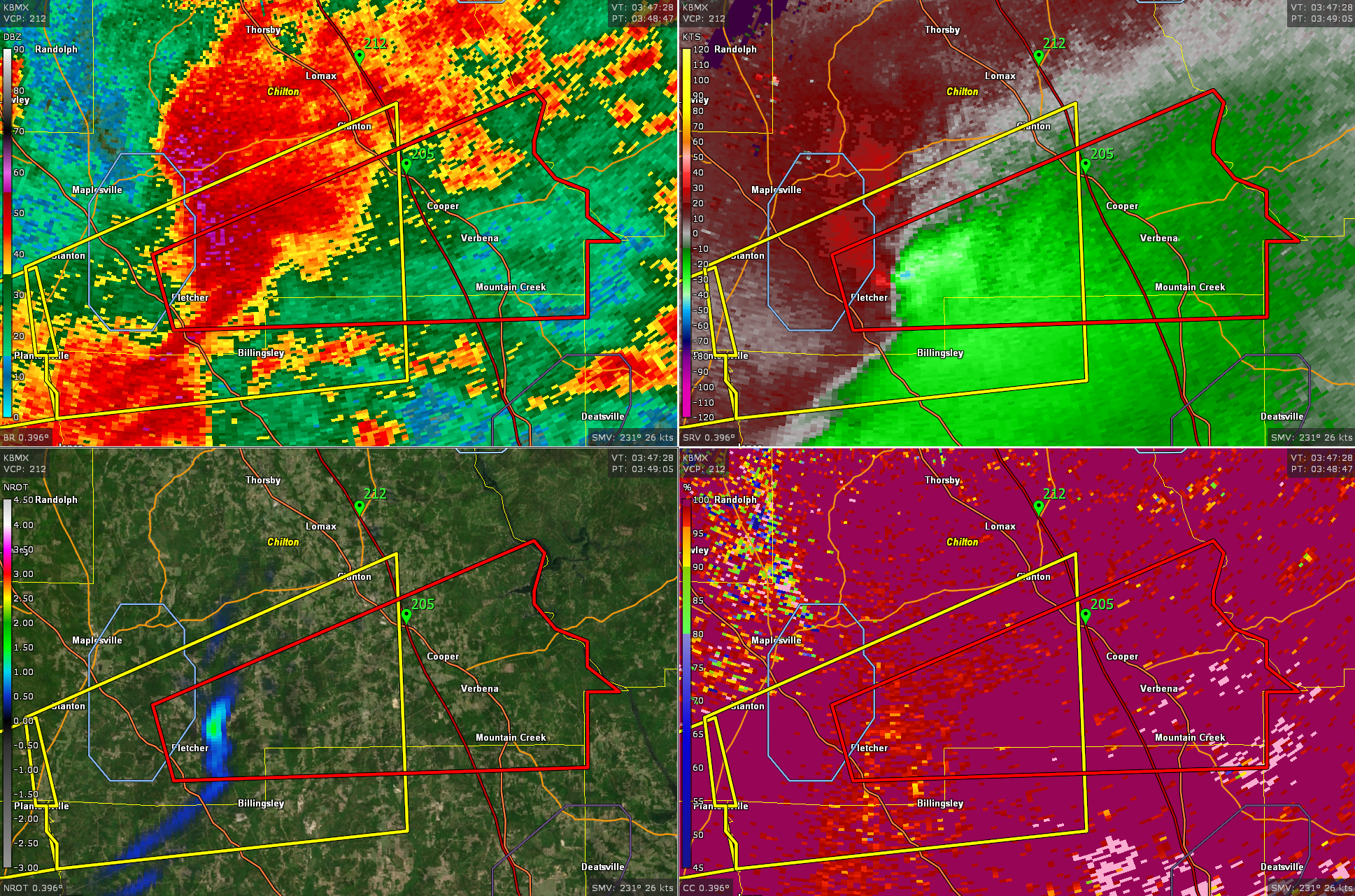
No one shoudl be driving between exits 186 and 212 on I-65.
BULLETIN – EAS ACTIVATION REQUESTED
Tornado Warning
National Weather Service Birmingham AL
1049 PM CDT Tue Apr 2 2024
The National Weather Service in Birmingham has issued a
* Tornado Warning for…
Northeastern Autauga County in central Alabama…
Southeastern Chilton County in central Alabama…
* Until 1130 PM CDT.
* At 1049 PM CDT, a severe thunderstorm capable of producing a
tornado was located over Pooles Crossroads, or 10 miles southwest
of Clanton, moving east at 50 mph.
HAZARD…Tornado.
SOURCE…Radar indicated rotation.
IMPACT…Flying debris will be dangerous to those caught without
shelter. Mobile homes will be damaged or destroyed.
Damage to roofs, windows, and vehicles will occur. Tree
damage is likely.
* Locations impacted include…
Clanton, Plecher, Marbury, Higgins Ferry Park, Verbena, Pooles
Crossroads, Mitchell Lake, Cooper, and Mitchell Dam.
PRECAUTIONARY/PREPAREDNESS ACTIONS…
TAKE COVER NOW! Move to a basement or an interior room on the lowest
floor of a sturdy building. Avoid windows. If you are outdoors, in a
mobile home, or in a vehicle, move to the closest substantial shelter
and protect yourself from flying debris.
&&
LAT…LON 3268 8680 3274 8682 3287 8646 3286 8645
3283 8646 3282 8646 3280 8644 3279 8641
3277 8641 3275 8638 3275 8641 3269 8641
TIME…MOT…LOC 0349Z 252DEG 43KT 3272 8674
TORNADO…RADAR INDICATED
MAX HAIL SIZE…<.75 IN
Category: Alabama's Weather, ALL POSTS, Severe Weather
About the Author (Author Profile)
Bill Murray is the President of The Weather Factory. He is the site's official weather historian and a weekend forecaster. He also anchors the site's severe weather coverage. Bill Murray is the proud holder of National Weather Association Digital Seal #0001 @wxhistorianSubscribe
If you enjoyed this article, subscribe to receive more just like it.


