Sunday Video Briefing: Eclipse Mania, Flooding Threat by Midweek
Saturday was a pretty day across Alabama, with just a few mid-level clouds moving across the middle of the state and highs in the 60s North and Central and lower 70s over South Alabama. Perfect weather is on tap for Sunday across the area, so get out and enjoy it, especially given that rain will be a part of the forecast Monday through Thursday. Flooding could become a concern by midweek, so we will spend a good bit of time exploring that. Severe weather does not appear to be a problem, but we will monitor that as well. And, of course, Eclipsemania is on the menu…
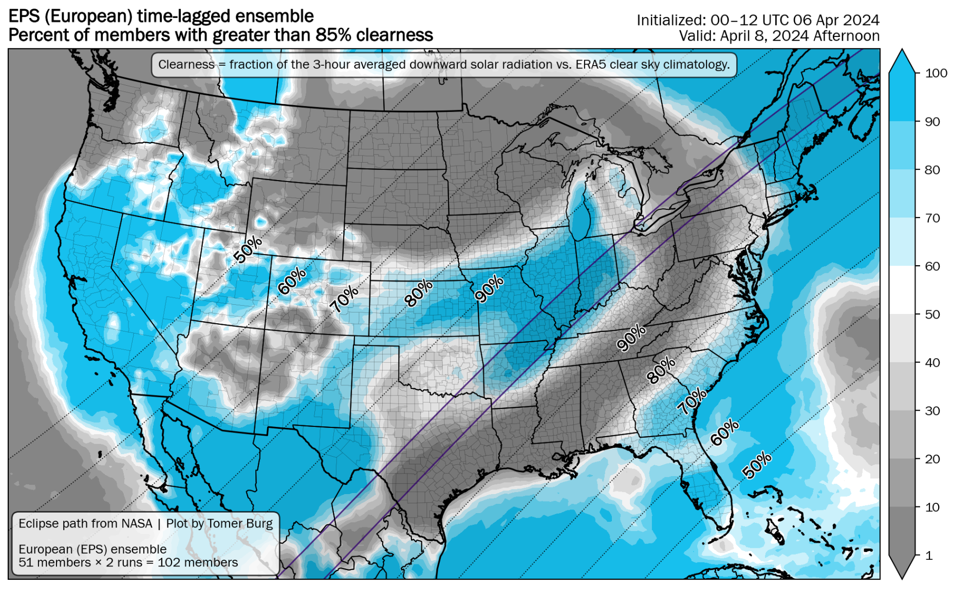
ECLIPSE FORECAST: Many people have been pulling their hair out the past few days trying to figure out where to go for Monday’s total eclipse. I had reserved rooms in San Antonio, Texarkana, Batesville, AR, and Cleveland. It has been pretty clear for two weeks that the Texas Hill Country did not look good. Rochester, NY, was starting to look good, but now I think NE Arkansas is it for me. Northeastern Arkansas, Illinois, Indiana, Vermont, and Maine appear to be the winners. According to the National Blend of Models, the country’s best place is Houlton, ME, with a 100% chance of favorable viewing. Our friend Mark Sudduth from HurricaneTrack.com is going there.
WHAT ABOUT HERE: The eclipse will begin here (Birmingham) at 12:40 pm CDT. It will reach its maximum of 87.9% at 2 p.m. CDT and end at 3:17 p.m. Cloud cover will be the problem. The National Blend of Models predicts that cloud cover over Birmingham will be 65-70% during the eclipse.
FOR YOUR SUNDAY: An absolutely gorgeous Sunday is in store for us here in North and Central Alabama. We are starting off chilly, with morning readings between 38-44 across the area. Skies will remain mostly sunny through the day, with some increasing clouds late in the afternoon. This may lead to some gorgeous sunset pictures, so be ready. Highs this afternoon will range between 74-79F. After midnight tonight, a few showers and a little thunder may reach the state, remaining north of I-20 overnight.
ECLIPSE DAY: Skies will start out mostly cloudy by Monday morning. Morning lows will be in the lower 50s east and upper 50s west, where the cloud cover will have been thicker and longer. A few scattered showers will continue throughout the day, lifting out to the northwest late into the evening as the next storm system moves in from the west. It will be warm tomorrow with highs in the lower and middle 70s across the Tennessee Valley and upper 70s to near 80F across the Central part of the state. Rain should overspread the northern half of the state Monday night. Thunder doesn’t look likely, but it is April. Monday night lows will be in the middle and upper 50s areawide.
SEVERE WEATHER MONDAY: The SPC has a large part of Texas and adjacent areas of Oklahoma, Arkansas, and Louisiana included in a slight risk (level 2/5) for Monday and Monday night. The marginal risk area (level 1/5) extends over to Memphis and Jackson, MS.
SEVERE WEATHER REST OF WEEK: A multi-day severe weather threat will exist across the southern tier of states. A lot of the state areas will be affected Tuesday, from much of Texas into southern Oklahoma, southwestern Arkansas, and much of Louisiana. Wednesday will feature areas from eastern Texas across the southern half of Arkansas, all of Louisiana, much of Mississippi, into Southwest Alabama. By Thursday, the activity will be across much of South Carolina, Georgia, extreme Southeast Alabama and northern Florida.
TUESDAY FOR US: More showers and some thunder are expected on Tuesday and Tuesday night. With a saturated atmosphere and lots of cloudiness, severe weather won’t be a threat. Temperatures on Tuesday will be in the 70s.
WEDNESDAY – THREAT OF FLOODING: Heavy rain will be likely on Wednesday, spreading from northwest to southeast. Rainfall could cause flooding with widespread 2-3 inch amounts with some amounts in excess of 5 inches in 24 hours. 3 day totals will be around 1-2 inches across the Tennessee Valley, with 3-5 inch amounts widespread across Central Alabama.
THURSDAY SHOWERS: Instability showers will be likely on Thursday with a big cut off low to the north of Alabama. Our winds will be gusty at times, and highs will be in the upper 60s and lower 70s. Thursday night lows will be in the upper 40s to lower 50s.
LOOKING TO THE WEEKEND: Friday will be partly cloudy and airish, with highs between 69-74F and a brisk westerly wind. Saturday will feel better, with highs in the upper 70s and less wind. Sunday will be a perfect spring day with partly cloudy skies and an average high near 80F.
VOODOO TERRITORY: Another storm system will move in on Tax Day, Monday the 15th. The initial looks on the GFS don’t indicate big severe weather, which is great news. By week two, we are firmly into spring and the temperatures start to show it with highs in the upper 70s to lower 80s and lows around 60F.
BEACHCAST: Tuesday and Wednesday look wet, the rest of the week looks good. Highs all week will be in the 70s, lows will be in the 60s. Water temperatures are in the upper 60s. Rip current risk will be low to moderate through midweek.
Click here to see the Beach Forecast Center page.
OMINOUS HURRICANE SEASON FORECAST: As the specter of the 2024 Atlantic hurricane season looms large, experts from Colorado State University have cast a foreboding shadow with predictions of an “extremely active” period, the likes of which could etch its mark as one of the busiest seasons on record. With a staggering forecast of 23 named storms, 11 hurricanes, and 5 major hurricanes, surpassing the average counts significantly, the anticipation is not just based on numbers but on the potent combination of La Niña conditions and anomalously warm ocean temperatures fostering an environment ripe for storm genesis. Such a forecast, underpinned by historical analog years like 1878, 1926, 1998, 2010, and 2020, paints a picture of heightened activity across the Caribbean, the Gulf of Mexico, and the Atlantic seaboard. This prediction, unsettling in its potential for destruction, underscores the urgent need for preparedness among those in the forecasted paths, from updating homeowners’ insurance to solidifying evacuation plans, as it only takes one where your home or business is located.
NATIONALLY: Freeze warnings and frost advisories are in effect this morning in an arc from Indiana and Ohio eastern Kentucky and Tennessee, back through upstate South Carolina, much of North Carolina, and into southern Virginia. Wind advisories and high wind warnings are in effect for much of the eastern Rockies into the Central Plains. Winds gusted to 60-90 mph today across southeastern Wyoming, eastern Colorado, and southwestern Nebraska. Winds gusted to 91 mph Saturday afternoon at Buckeye, Colorado.
DANCING WITH THE STATS: 56F In Las Vegas NV on Friday was a record cold maximum high for the date. 93F yesterday in San Juan PR tied the record high for the date there.
ADVERTISE WITH US: Deliver your message to a highly engaged audience by advertising on the AlabamaWX.com website. We have a lot of big plans for this year. Don’t miss out! We can customize a creative, flexible, and affordable package that will suit your organization’s needs. Contact me, Bill Murray, at (205) 687-0782 and let’s talk.
WEATHERBRAINS: This week will be a home grown show since the eclipse has most potential guests enroute back from some viewing location. Sometimes, the home grown shows are special. Check out the show at www.WeatherBrains.com. You can also subscribe on iTunes. You can watch the show live on our new YouTube channel for the show.You will be able to see the show on the James Spann 24×7 weather channel on cable or directly over the air on the dot 2 feed.
ON THIS DATE IN 2007: The mercury plummeted across Alabama as one of the coldest April airmasses in history affected parts of the Deep South. It was 26F at Muscle Shoals and 27F at Huntsville, both records for the date. A passing upper disturbance caused cloud cover over parts of the state overnight, limiting the temperature drop over Central sections, where lows were closer to 30 degrees. It was 30F at Birmingham. A few snow flurries associated with the disturbance over parts of North Central Alabama during the late evening hours the night before. No accumulations occurred, but there was a lot of excitement as the flakes fell. Meanwhile, growers were preparing for even colder temperatures for the following night, when readings were expected to fall into the middle 20s. Follow my weather history tweets on Twitter. I am @wxhistorian at Twitter.com.
Category: Alabama's Weather, ALL POSTS, Severe Weather
About the Author (Author Profile)
Bill Murray is the President of The Weather Factory. He is the site's official weather historian and a weekend forecaster. He also anchors the site's severe weather coverage. Bill Murray is the proud holder of National Weather Association Digital Seal #0001 @wxhistorianSubscribe
If you enjoyed this article, subscribe to receive more just like it.


