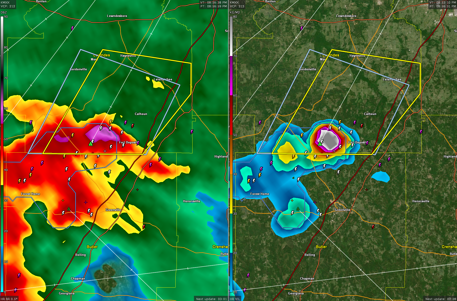
Severe Thunderstorm Warning for Southeastern Lowndes County
Strong indications of large hail 5 miles WSW of Fort Deposit.
Lots of lightning, heavy rain, and the potential for damaging wind gusts in addition to the hail.
Be in a sturdy shelter is this storm is approaching your location.
BULLETIN – IMMEDIATE BROADCAST REQUESTED
Severe Thunderstorm Warning
National Weather Service Birmingham AL
854 PM CDT Sat Apr 20 2024
The National Weather Service in Birmingham has issued a
* Severe Thunderstorm Warning for…
Southeastern Lowndes County in south central Alabama…
* Until 930 PM CDT.
* At 854 PM CDT, a severe thunderstorm was located near Lowndes
County Airport, or near Fort Deposit, moving northeast at 30 mph.
HAZARD…60 mph wind gusts and quarter size hail.
SOURCE…Radar indicated.
IMPACT…Hail damage to vehicles is expected. Expect wind damage
to roofs, siding, and trees.
* Locations impacted include…
Fort Deposit, Mosses, Hayneville, Gordonville, Lowndes County
Airport, Beechwood, Calhoun, Mount Willing, Clover Hill, and
Letohatchee.
PRECAUTIONARY/PREPAREDNESS ACTIONS…
For your protection move to an interior room on the lowest floor of a
building.
&&
LAT…LON 3220 8665 3217 8641 3210 8641 3196 8654
3196 8681
TIME…MOT…LOC 0154Z 218DEG 24KT 3201 8665
HAIL THREAT…RADAR INDICATED
MAX HAIL SIZE…1.00 IN
WIND THREAT…RADAR INDICATED
MAX WIND GUST…60 MPH
Category: Alabama's Weather, ALL POSTS, Severe Weather
About the Author (Author Profile)
Bill Murray is the President of The Weather Factory. He is the site's official weather historian and a weekend forecaster. He also anchors the site's severe weather coverage. Bill Murray is the proud holder of National Weather Association Digital Seal #0001 @wxhistorianSubscribe
If you enjoyed this article, subscribe to receive more just like it.


