Sunday Weather Briefing Video: Rain this Morning, But We Get the Race in This Afternoon
It was a rainy night in Birmingham and across much of Alabama last night as a big area of rain and some embedded thunder moved across the area. .44 inches of rain fell last evening at the Birmingham Shuttlesworth International Airport. That was the exact same amount that fell Friday night there. Go figure!
GIDDY UP! The Stallions pulled out a thriller after an hour and 26 minute lightning delay at Protective Stadium last night, taking them to 4-0. Our team is the last undefeated team in the United Football League.
RACE DAY: It’s Race Day at Talladega! If you’re a NASCAR fan with tickets to the GEICO 500 today, you are probably listening to the rain or your house or hotel room on this Sunday morning, and thinking, can I make the race if it is held tomorrow? Well, not to worry. The area of rain and some thunder moving across the area since the early morning hours will be out of eastern Alabama by late morning, and out of Talladega by 10-11 a.m. With the green flag dropping at 2 p.m., there is only a small chance of a passing shower during the race. Can’t rule out a short delay, but I think they will get the race in. High temperatures will be in the upper 50s to lower 60s.
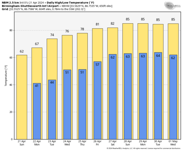
TONIGHT: Skies will be mostly clear overnight with just a few passing clouds. With calm winds and low dewpoints, lows will drop into the upper 30s in a few of the normally colder locations. Could there be a little frost in protected valleys? Probably not. Most folks will be in the lower 40s.
PERFECTION AHEAD: Monday will be a nice day with total sunshine, but slightly cool temperatures in the middle 60s to lower 70s. Monday night lows will be in the lower 40s. Tuesday will be warmer, with highs in the lower and middle 70s. Wednesday will be absolutely perfect with lots of sunshine and highs in t he middle 70s. A dry front will push through late Wednesday, but Thursday will be just as nice with highs again in the middle and upper 70s.
WEEKEND OUTLOOK: Friday and Saturday will feature increasing humidity and cloudiness with a chance of a widely scattered shower or storm both days. Rain chance s will continue into Saturday night and Sunday, with mostly cloudy and warm conditions. Highs each day will be in the 80s. Lows will be in the 60s.
BEACHCAST: Rain and storms should be over along the beautiful beaches of Alabama and Northwest Florida by late tonight. Then no significant rain is foreseen through much of the next two weeks. Highs will be in the 70s until Thursday, and then near 80 through the weekend into the first part of the following week. Lows will warm through the 50s by the weekend, with 60s in the week two period.
VOODOO PERIOD: Much of the week two period will feature scattered showers and storms each day, in a little preview of summer. Highs will be in the middle 80s each day. An approaching cold front will bring more widespread showers and storms around Thursday and Friday the 2nd and 3rd. Rainfall won’t be too prolific, in the one half inch range on average.
NATIONALLY: Freeze warnings are in effect early this morning across parts of the Upper Midwest including Nebraska, Iowa, Minnesota, Wisconsin, and Illinois. Freeze watches will be common tonight from the Texas and Oklahoma Panhandles over to the Ohio Valley. Hopefully, they won’t be needed here.
WEATHERBRAINS: This week, the panel will entertain the team from the Tennessee Valley Weather Channel. They are a great group of folks led by Ben Luna, one of the nicest people you would ever want to meet. Check out the show at www.WeatherBrains.com. You can also subscribe on iTunes. You can watch the show live on our new YouTube channel for the show.You will be able to see the show on the James Spann 24×7 weather channel on cable or directly over the air on the dot 2 feed.
ON THIS DATE IN 2004: Oklahoma City residents are accustomed to walking outside to find a blanket of white covering the ground. But not in late April on a day which started out with temperatures in the upper 70s. The layer of white was not snow, but rather hail, which fell in prodigious amounts as massive supercell thunderstorms pounded the Oklahoma City metro area. Traffic was snarled on area highways, including I-44, as cars could not drive on roads slick with the ice. Follow my weather history tweets on Twitter. I am @wxhistorian at Twitter.com.
Category: Alabama's Weather, ALL POSTS


