Sunday Morning Weather Update: A Significant Tornado Outbreak in Oklahoma Yesterday
***GOOD MORNING…NO VIDEO THIS MORNING BECAUSE OF COMPUTER ISSUES****
On this date, thirteen years ago, Alabamians were waking up to the shock and realization that we had been through a generational tornado outbreak with an unthinkable death toll in an age of what we feel is advanced warning techniques. It still just reminds us that we still have a long way to go to protect people from severe weather. Fortunately, nothing like that for the foreseeable future here in Alabama.
SEVERE WEATHER YESTERDAY: Saturday was a volatile day across parts of North Texas, much of central Oklahoma, and southeastern Kansas. Multiple supercells in an unstable, sheared, and uncapped atmosphere produced large hail, damaging winds, and tornadoes. The day started late in the morning with a PDS (Particularly dangerous situation) tornado watch for areas from Vernon and Wichita Falls, Texas, to Lawton, Oklahoma City, and Ponca City in Oklahoma. Three tornadic supercells passed over Ardmore, Oklahoma, during the late evening. A tornado passed through the western part of Ardmore around 9:50 p.m. Debris was lofted to over 20,000 feet, indicative of a strong tornado. At least three monster tornadoes were on the ground just before 11 p.m. in Oklahoma. Three tornadoes passed over Lake Murray, southeast of Ardmore. Some of the worst damage appears to be from Sulphur, Oklahoma.
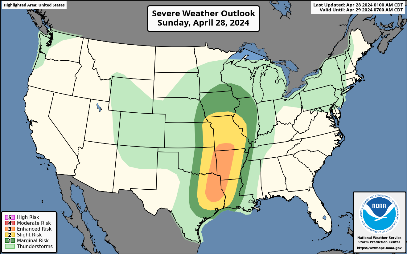
SEVERE WEATHER TODAY: The severe weather threat shifts a little east today, from southeastern Iowa and western Illinois across much of Missouri, eastern Kansas, eastern Oklahoma, and eastern Texas into western Arkansas and northwestern Louisiana. Today’s greatest tornado threat will exist from St Louis down to Shreveport, Alexandria, Waco, and Dallas.
SATURDAY WAS A NICE DAY: Saturday was a warm and windy day across Alabama. With a variable sky but plenty of sunshine, temperatures warmed into the lower 80s. There was a breezy southerly wind.
SUNDAY’S WEATHER: The weather on Sunday in Central Alabama will be similar to today’s, featuring a blend of sunshine and clouds. There’s a slight possibility of a few light sprinkles in the western areas. Temperatures will reach the low to mid-80s. Winds could gust to 20 mph at times. It’s a great day to enjoy the outdoors, whether you’re appreciating natural scenery or catching some fast-paced excitement at Barber Motorsports Park.
THE WEEK AHEAD: The upcoming week sees a notable shift in the weather pattern starting Monday. From Monday through Tuesday, an upper trough moving from the Plains states toward the Great Lakes will influence weather across the Central Gulf Coast states, including Alabama. This will bring the best chance for rainfall early in the week, particularly on Monday afternoon and night. However, as the trough weakens upon its approach, the northern parts of the expected rainfall line might dissipate, with more robust convection likely trending southeast towards southern Mississippi, where instability is greater. This should keep any severe storms confined to Mississippi. By Wednesday, rain chances decrease as a weak upper ridge begins to build over the area, likely leading to drier conditions for the remainder of the week.
WEEKEND OUTLOOK: Looking ahead to next weekend, the forecast suggests a continuation of the drier conditions established later in the week. The weak upper ridge is expected to remain in place, likely resulting in stable and possibly warmer weather. While specific details may still be refined as the week progresses, early indications point to a weekend free of significant rainfall, making it ideal for outdoor activities and events.
BEACHCAST: Another nearly perfect week along the beautiful beaches of Alabama and Northwest Florida. The only exception will be a few showers late Monday into Tuesday. Highs will be between 80-84. Lows will be in the 60s. There is a high rip current risk through Wednesday. The water temperatures are running in the lower 70s.
Click here to see the Beach Forecast Center page.
WEATHERBRAINS: This week, the panel will be talking about the false alarm issue in our warning process. Kevin Laws from the National Weather Service in Birmingham will join us. The expertise of our very own Kim Klockow McClain will be vital. Check out the show at www.WeatherBrains.com. You can also subscribe on iTunes. You can watch the show live on our new YouTube channel for the show.You will be able to see the show on the James Spann 24×7 weather channel on cable or directly over the air on the dot 2 feed.
ON THIS DATE IN 1863: There are important professional designations in nearly every field, and meteorology is no exception. We have Seals of Approval, and CCMs and CBMs. Perhaps the first designation was a self-appointed one, a Certified Practical Meteorologist. A man named Frances Capen gained access to President Abraham Lincoln during the Civil War, promising that his weather forecasts could save “thousands of lives and millions of dollars.” His first official forecast was a bust on this date. David Ludlum says that President Lincoln wrote: “It seems to me that Mr. Capen knows nothing about the weather, in advance. He told me three days ago it could not rain again till the 30th of April or 1st of May. It is raining now [and} has been for ten hours. I can not spare any more time to Mr. Capen.” Follow my weather history tweets on Twitter. I am @wxhistorian at Twitter.com.
Category: Alabama's Weather, ALL POSTS, Severe Weather
About the Author (Author Profile)
Bill Murray is the President of The Weather Factory. He is the site's official weather historian and a weekend forecaster. He also anchors the site's severe weather coverage. Bill Murray is the proud holder of National Weather Association Digital Seal #0001 @wxhistorianSubscribe
If you enjoyed this article, subscribe to receive more just like it.


