Saturday Briefing — Some Stormy Weather Today; Much Better on Sunday
SOME STORMS TODAY; A DRY SUNDAY AHEAD
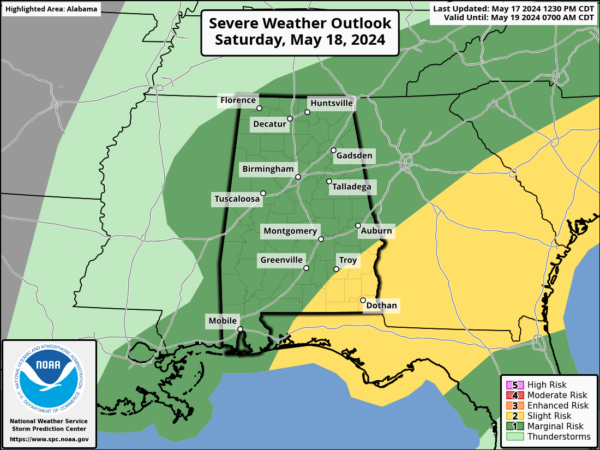
We have a rather dynamic weather system heading our way today. A shortwave will move through the northern parts of Central Alabama and up into North Alabama, bringing with it a mix of decent instability and higher mid-level lapse rates. This setup means we could see the development of strong to severe thunderstorms capable of producing hail and strong to damaging winds. A marginal risk is up for all of North and Central Alabama, with the main window for stronger storms to take place from 12pm to 8pm. The best chances for those stronger storms will be along and north of I-20, but don’t rule out strong storms across the southern portions. As we move into the nighttime hours, the rain and storm activity will start to wind down, with most of the area drying out just after midnight. Expect highs in the lower to mid-80s.
Now, looking ahead to Sunday, we’re expecting a big change. We’ll be entering a short dry spell that should last into midweek. A developing ridge will stabilize the atmosphere over Central Alabama, giving us mostly sunny skies and highs in the 80s.
DRY TO START THE WEEK; A FEW SCATTERED STORMS TO END THE WEEK
By Monday, with that ridge firmly in place, our temperatures will start to rise a few degrees. We’re looking at sunny skies with highs in the mid to upper 80s, and we might even see a few spots hitting the 90s.
On Tuesday, a few clouds will start to creep back into the forecast as moisture levels begin to increase, and we start to feel a bit more humidity. For now, we’re keeping the word “muggy” out of the forecast, but heat index values will be a degree or two warmer than the actual temperatures. Expect partly to mostly sunny skies, with highs in the upper 80s to lower 90s.
Wednesday will be another very warm to hot day with partly to mostly sunny skies. However, it looks like we might see some scattered showers and storms moving into Central Alabama during the late-night and overnight hours. Highs will be in the upper 80s to lower 90s.
By Thursday, we’ll have a bit of an unsettled weather pattern over Central Alabama as higher humidity levels make it feel a little more uncomfortable. Skies will be partly to mostly cloudy with a chance of scattered showers and storms, especially during the afternoon and evening hours. Highs will be in the mid to upper 80s, with the heat index topping out about 2-4 degrees warmer.
Finally, on Friday, the weather doesn’t look quite as unsettled. Latest forecast models are showing only a small chance of a few isolated to scattered showers and storms. Skies will be partly sunny with highs in the mid to upper 80s. Dewpoints will be teetering on the line between uncomfortable and muggy. I was hoping not to go there, but it looks like I needed to this time.
Category: Alabama's Weather, ALL POSTS, Severe Weather


