Hot Weekend Ahead; The Heat Hits Hard
THIS WEEKEND’S OUTLOOK
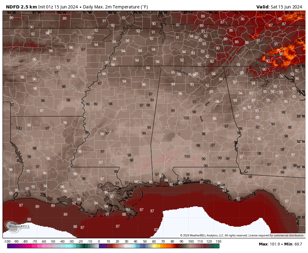
While we’ll have a weak frontal boundary approaching from the north, don’t expect any relief from the heat through the day today, as a strong ridge will set up shop over the southeast. Even with lower humidity levels, highs reaching the lower 90s to the lower 100s will still feel like a few degrees hotter. Skies will be sunny, and winds will be very light.
Unfortunately, overnight lows will be quite warm, which will not really give us any heat relief at all. Sunday will be another scorcher with sunny skies and highs in the mid to upper 90s. Heat indices will be several degrees hotter, but just below advisory criteria.
NEXT WEEK’S OUTLOOK
Ridging will slightly shift eastward on Monday, which will allow for slightly cooler temperatures as we will see an increase in moisture levels and bring a small chance of scattered showers and storms to the west and southwestern parts of Central Alabama. Skies will be partly sunny, with highs in the lower to mid 90s. Tuesday will continue the slight cooldown as some clouds will help to keep those daytime highs away from the triple digits. Skies will be partly sunny, with highs in the upper 80s to the lower 90s.
The ridging breaks down somewhat to end out the work week, as we’ll start to see some impulses move in our direction on Wednesday. However, we’ll stay dry with highs reaching the upper 80s to the mid 90s underneath partly sunny skies. On Thursday, heat builds off to our west over Mississippi, but we’ll continue with highs in the upper 80s to the mid 90s under sunny skies. Friday looks to be an exact duplicate of Thursday, with sunny skies and highs in the lower to mid 90s.
TROPICAL OUTLOOK: 9 pm Friday Night
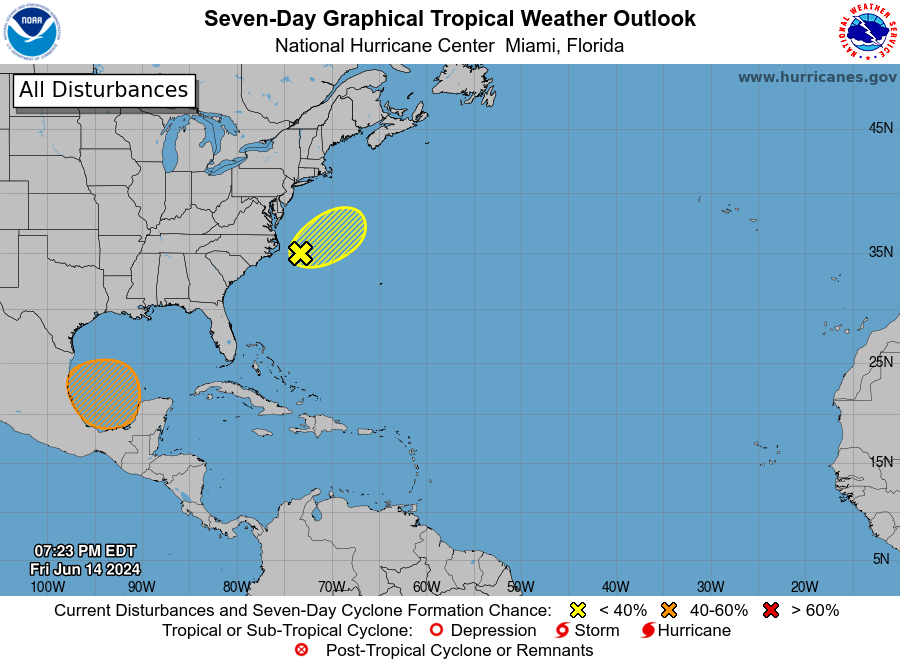
An area of low pressure offshore of the southeastern U.S. coast in the western Atlantic (AL90) is producing some disorganized shower and thunderstorm activity. The system is unlikely to acquire tropical characteristics due to strong upper-level winds while it moves northeastward over the western Atlantic and merges with a front on Saturday. For more information on this system, including Gale Warnings, see High Seas Forecasts issued by the National Weather Service. The formation chance through 48 hours is low at 10 percent, and the formation chance through 7 days is also low at 10 percent.
A broad area of low pressure is forecast to form over the southwestern Gulf of Mexico late this weekend or early next week. Environmental conditions appear conducive for gradual development of this system, and a tropical depression could form during the early or middle part of next week while it moves slowly westward or west-northwestward. The formation chance through 48 hours is low, near 0 percent, but the formation chance through 7 days is medium at 50 percent.
ON THIS DAY IN WEATHER HISTORY: 1991
On June 15, 1991, a severe weather outbreak occurred in the Ohio Valley region, particularly affecting parts of West Virginia and Pennsylvania. This outbreak featured numerous severe thunderstorms, producing destructive winds, large hail, and several tornadoes. One of the most notable events was a deadly F3 tornado that struck the town of Shinnston, West Virginia.
• Strength: The Shinnston tornado was classified as an F3 on the Fujita Scale, with winds estimated between 158 and 206 mph.
•Path: The tornado cut through residential areas, causing widespread destruction.
• Damage: Many homes and businesses were damaged or destroyed, and there was significant infrastructure damage.
• Casualties: The tornado resulted in two fatalities and numerous injuries, making it one of the deadliest and most destructive tornadoes in West Virginia’s history on that date.
CELEBRATING NATIONAL DAYS
So, we have a list of events, festivals, weird, funny, and national days set for this day of the year. Here’s what we can celebrate or help contribute to:
• National Nature Photography Day
• National Smile Power Day
• Global Wind Day
• National Lobster Day
• National Megalodon Day
• National Prune Day
SEVERE WEATHER SAFETY
Weather can be unpredictable, catching us off guard with its sudden changes. From thunderstorms to tornadoes or flash floods, being ready beforehand can be a lifesaver. Alabama, with its varied climate, faces its share of severe weather. That’s why having a solid safety plan is so important for everyone. Check out our Severe Weather Safety Guide for valuable tips on how to stay safe when severe weather is on the horizon.
Category: Alabama's Weather, ALL POSTS, Tropical
About the Author (Author Profile)
Scott Martin is an operational meteorologist, professional graphic artist, musician, husband, and father. Not only is Scott a member of the National Weather Association, but he is also the Central Alabama Chapter of the NWA president. Scott is also the co-founder of Racecast Weather, which provides forecasts for many racing series across the USA. He also supplies forecasts for the BassMaster Elite Series events including the BassMaster Classic.Subscribe
If you enjoyed this article, subscribe to receive more just like it.


