Sunday Morning Weather Briefing Video: Heat and Hurricanes
Heat and hurricanes are the story on the last day of June 2024. Heat advisories are in effect for all of the state today as temperatures are expected to reach the middle and upper 90s with a few spots in South Central Alabama perhaps touching 100F. But the high dewpoints are going to drive those heat index values into the 100-105F range early this afternoon, which is approaching and into the dangerous category. Use all the normal precautions including taking it easy, and taking frequent breaks if you are playing or working outside. Hydrate often. Wear loose fitting, light colored clothing, especially a hat, and apply sunscreen. Make sure pets have plenty of water. And check on friends, family, and neighbors.
SCATTERED STORMS
Showers and storms will form with the heat of the day and with a boundary to our north. These storms will drift southward and dissipate this evening. Nothing severe expected, but there could be a few strong wind gusts, as well as brief very heavy rain, and dangerous lightning.
A NORMAL SUMMER FORECAST FOR THE SHORT WORK WEEK & THE HOLIDAY
Believe it or not, a cold front will work through much of the area on Monday that will bring us a little relief from the mugginess. Skies will be partly to mostly sunny across the area as the front makes it to around the I-85 corridor. Highs will still be hot, as we’ll hit the upper 80s to the upper 90s, even though heat index values should stay out of the 100s for much of the area.
Ridging begins to build back in on Tuesday, allowing the mugginess to start returning. A few isolated to scattered showers may be possible over the east and southeastern locations, while the rest of Central Alabama looks to stay rain-free. Highs throughout the 90s.
The rest of the week looks like your typical summer forecast for Central Alabama. Skies will be partly sunny with a chance of widely scattered showers and storms on Wednesday through Friday with highs well up into the 90s, with heat advisories possible each day.
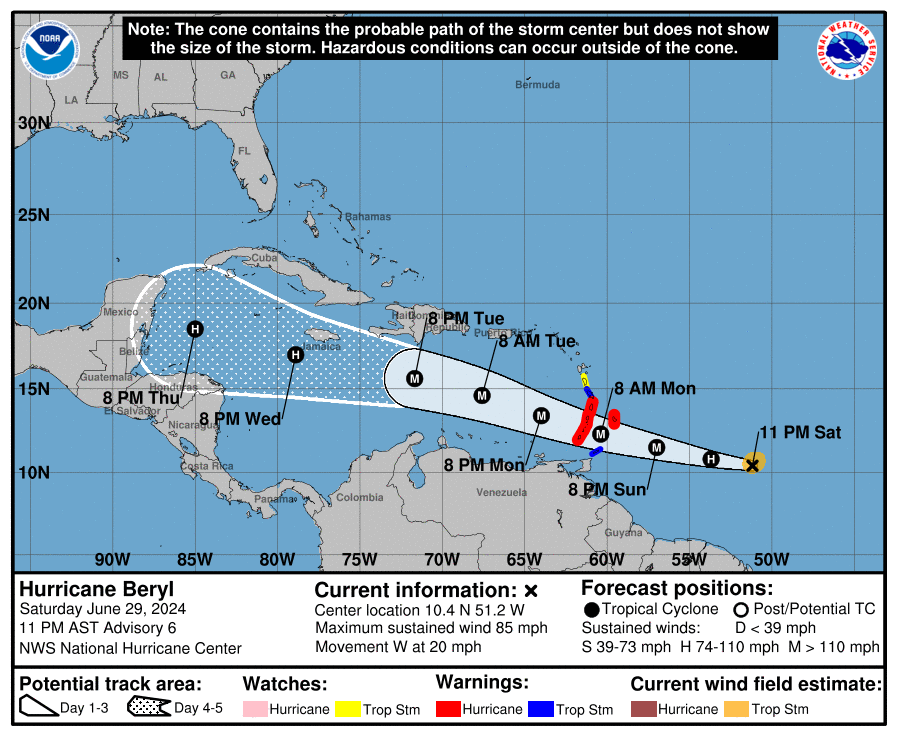
BUSTLING BERYL
Beryl became a hurricane Saturday evening as it continued to rapidly intensify. It is about 480 miles east southeast of St. Vincent in the Windward Islands early this morning. Top winds are around 105 mph as that rapid intensification continues. The forecast track carries it across the southern Lesser Antilles, specifically the Windward Islands during the morning on Monday. Tropical storm force winds will begin in the islands early Monday, generally around 2 a.m. CDT in Barbados, St. Vincent and the Grenadines and St. Lucia around sunrise, and Grenada around mid-morning. Those winds will increase to strong tropical storm force around mid-to-late morning. The center and eyewall will reach the Windwards around 10 a.m. somewhere between Grenada and St. Lucia. Hurricane warnings are in effect for St. Lucia, St. Vincent, the Grenadines, and Grenada. A tropical storm warning is in effect for Martinique, and tropical storm watches are up for Dominica and Tobago. Additional warnings may be required later today.
BARRELING BERYL
Beryl will move into he southeastern Caribbean as a strengthening hurricane. It will spend Tuesday on a Caribbean cruise, passing well south of Puerto Rico and Hispaniola. But Haiti and the Dominican Republic will feel the heavy rain and rough surf, as well as winds to near tropical storm force. By Wednesday morning it will be approaching Jamaica, about 150 miles southeast of Kingston. The hurricane should be weakening by then, with top winds dropping to around 100-105 mph. But sea surface temperatures and oceanic heat content all along its track are very high, so I am a bit skeptical of the weakening forecast. The hurricane will be approaching the Yucatan by late Thursday, perhaps still as a hurricane. It will cross the Yucatan and enter the Gulf by Friday night and approach the Lower Texas Coast or northeastern Mexico by Sunday. Leading candidate for landfall right now is Corpus Christi, Texas. It could be category one or two hurricane then. But it is way too early to solidify that forecast.
OTHER TROPICAL ACTIVITY
A broad area of low pressure, known as Invest 94L, still could intensify into a tropical depression or tropical storm over the Bay of Campeche today or tonight before moving inland. Interests along the Gulf coast of Mexico should monitor the progress of this system. Regardless of development, heavy rainfall associated with the area of low pressure will affect portions of Central America and Mexico through early next week.
Invest 96L is about 1,200 miles east of Beryl this morning. It is likely that it will become a tropical depression over the next 48 hours and could become Tropical Storm Chris if 94L doesn’t beat it to the punch today. Then it would likely be Debby.
BEACH FORECAST
Please visit our Beach Forecast Center page to access the most up-to-date weather and rip current forecasts for the beaches spanning from Fort Morgan to Panama City. On this platform, you can choose the forecast specific to the region you intend to visit, ensuring you have accurate and relevant information for your plans.
E-FORECAST
Receive the Alabama Weather Blog’s comprehensive Seven-Day Forecast directly to your inbox via email, delivered twice daily. Recognized as the most detailed weather forecast accessible in Central Alabama, our service ensures you stay informed and prepared. Subscribe now to access this valuable resource at no cost!
WEATHERBRAINS
This week we will be talking severe weather with two bigwigs from the National Weather Service Severe Weather Program. Tune in live Monday night at 7 p.m. CDT on YouTube at www.youtube.com/weatherbrains or on the ABC3340 dot 2 channel. The audio podcast will drop late Monday night on all the popular pocast platforms.
ON THIS DATE IN 1886
Tallahassee FL area was hard hit by a damaging hurricane, the second of three hurricanes to strike Florida within a month. Early season hurricanes are not uncommon in Florida, but three striking within a month so early in the season made 1886 an unusual year. Several fatalities occurred in Apalachicola.
Category: Alabama's Weather, ALL POSTS, Severe Weather, Tropical
About the Author (Author Profile)
Bill Murray is the President of The Weather Factory. He is the site's official weather historian and a weekend forecaster. He also anchors the site's severe weather coverage. Bill Murray is the proud holder of National Weather Association Digital Seal #0001 @wxhistorianSubscribe
If you enjoyed this article, subscribe to receive more just like it.


