Active Rain and Storms Today and Monday, Drier/Hotter for Midweek
Saturday started off mostly cloudy across much of North and Central Alabama. A passing disturbance triggered a large mass of showers and storms Friday afternoon across Mississippi. Still, it weakened slowly overnight as it moved into Alabama, and all that was left were some sprinkles during the early morning hours. Showers and storms formed across portions of North and Central Alabama during the afternoon, and some of them brought heavy rain and lightning. I picked up 0.24” in southern Jefferson County near the Acton Road exit off I-459. The Shuttlesworth Birmingham International Airport picked up 0.73”. This put BHM at 7.64” for the month, which moves it into 26th place in all-time July rainfalls. Another 1.25” between now and Wednesday, which is certainly possible, could put this month in the top 12 wettest Julys.
FOR YOUR SUNDAY: Temperatures are starting off rather uniformly this morning across the entire state, with low-temperature readings ranging between 71F and 73F. Skies are partly sunny to mostly cloudy, and there are already a few showers in the warm, humid airmass across the state. Showers and storms will increase by mid to late morning, and they will be fairly numerous and heavy this afternoon. Rainfall amounts will range from 0.15” to around 1.25” in some spots. No severe weather is expected, although some strong, gusty winds can’t be ruled out if we get wet microbursts. Highs will be generally clustered around the middle 80s.
MORE MOISTNESS FOR MONDAY: More showers and storms will form across North and Central Alabama on Monday, and rainfall could be excessive, especially near and north of I-20. The best chance for those excessive rains is over eastern Alabama, where over 1.25” of rain could fall on Monday. Highs on Monday will be a couple of degrees higher than today’s, thanks to more sunshine.
WARMER, DRIER FOR MID WEEK: The persistent upper-level low and trough to the west of Alabama are opening up and weakening. High-pressure ridging will replace the lower pressures and give us drier and warmer conditions. High temperatures will rise back into the middle 90s.
WEEKEND OUTLOOK: Friday should still be mainly dry, with partly cloudy skies and widely scattered afternoon and evening showers and storms. Temperatures will still be among the hottest of the week. Readings should back off for Saturday and Sunday, though, as clouds and daily storms resume their offensive. Highs both days should be around 90F.
WEEK TWO VOODOO: Scattered showers and storms will be in the forecast for much of the work week, but it seems things will be drying a bit by the weekend. Temperatures look like they will be right around normal, with highs 90-91F and lows in the 73-74F range.
BEACHCAST: Scattered to numerous showers and storms are forecast through Tuesday, with slightly decreased rain chances after that for the remainder of the week. The UV Index is very high, the rip current risk is low, and the surf heights are running around 1 foot. Water temperatures are in the upper 80s.
Click here to see the Beach Forecast Center page.
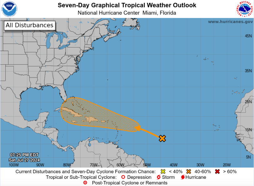
IN THE TROPICS: There is some possibility of tropical development late next week, around August 2nd, in the area from the far northwestern Caribbean to near the Bahamas. An area of disturbed weather located over the central Tropical Atlantic near 44 West Longitude has a low chance of developing but needs to be watched closely. This disturbance’s interaction with a couple of tropical waves near 39 West and 27 West Longitude might lead to its development as it heads west-northwestward. Environmental conditions over the central and eastern Tropical Atlantic are unfavorable for development due to dry air, which is likely capping any potential growth. However, model guidance varies, with the European model consistently forecasting development near the Bahamas late next week, while the GFS model has been less consistent. The Canadian model also predicts development in the northwestern Caribbean, potentially threatening the northern Gulf Coast around August 5. Residents from the northern Gulf Coast to the Southeast Coast of the United States should monitor this disturbance closely.
PACIFIC SIDE: Two hurricanes will form in the eastern Pacific during the next two weeks. One could reach category four status in week two. They are no threat to land.
NATIONALLY: It was so hot in Phoenix on Saturday afternoon that a Southwest Airlines flight had to take off and fly to Los Angeles, where the temperature was only 72F. When temperatures are extremely high, the air becomes less dense, reducing the lift generated by the aircraft’s wings. To ensure safe takeoff and climb performance, planes may need to reduce weight by carrying less fuel, cargo, or passengers. Sometimes, planes might divert to a cooler airport to refuel and then continue to their final destination.
DANCING WITH THE STATS: 4.55” of rain fell at the Birmingham International Airport between July 19th and 25th. This is a pretty decent rainfall amount for a 7-day period in July. In fact, it is the 70th largest total in Birmingham’s history. One of our friends of the blog, Robert, asked if the rainfall bounty over the past seven days is unprecedented. He received over six inches during the past week at his home on Birmingham’s Northside. Of course, you have to throw out July 1916, when a dying tropical cyclone dumped 14.54” over seven days, ending on the 11th. There was a 7.79” 7-day period in 1985, but it was highlighted by 5.47” on 7/27/1985. There was 7.53” between 7/11 and 7/17 in 1950, highlighted by 3.13” on 7/12. And 7.21” in 1968 between the 8th and 14th, punctuated by 3.96” on 7/9. So it isn’t unprecedented but always appreciated.
WEATHERBRAINS: The panel entertained DTN meteorologist and researcher Sam Lillo this week. I missed the show, but James told me it was great. The show was recorded Thursday night, and James will be on vacation this week. Check out the show at www.WeatherBrains.com. You can also subscribe on iTunes. You can watch the show live on our new YouTube channel for the show, and you can see the live show on the James Spann 24×7 weather channel on cable or directly over the air on the dot two feed.
ON THIS DATE IN 1819: The Bay St. Louis Hurricane of 1819 landed on the Mississippi Coast. The storm was the worst in 50 years and devastated the same area that Hurricane Camille would strike almost exactly 150 years later. 39 U.S. Man-of-War Firebrand crew members were lost when the storm sank the schooner. Mobile, AL, was in the more severe eastern semicircle of the hurricane and suffered heavy damage. It was reported that the water in Mobile was as high as in the Great Storm of 1852. Alligators and turtles washed up on the streets. A large ship was also grounded on Dauphin Street in the city. Follow my weather history tweets on Twitter. I am @wxhistorian at Twitter.com.
Category: Alabama's Weather, ALL POSTS, Tropical
About the Author (Author Profile)
Bill Murray is the President of The Weather Factory. He is the site's official weather historian and a weekend forecaster. He also anchors the site's severe weather coverage. Bill Murray is the proud holder of National Weather Association Digital Seal #0001 @wxhistorianSubscribe
If you enjoyed this article, subscribe to receive more just like it.


