Flash Flood Warning for Parts of Marion and Lamar Counties
Storm total rainfalls over parts of West central Alabama are really piling up. Parts of northern Marion have now seen 9 inches of rain over the last few days.
Very heavy rainfall from thunderstorms is dumping more heavy rains across our flash flood warning area this afternoon. The storms are backbuilding over the same areas and more storms are moving in from the west.
The area is very primed for excessive rainfall this afternoon and tonight.
Remember our mantra: Turn Around, Don’t Drown.
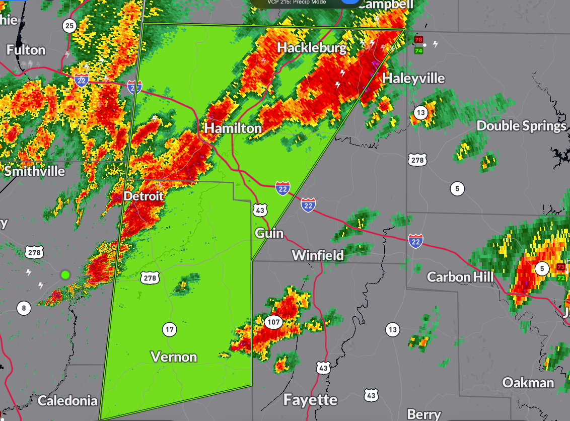
The National Weather Service in Birmingham has issued a
* Flash Flood Warning for…
Marion County in northwestern Alabama…
Lamar County in west central Alabama…
* Until 430 PM CDT.
* At 1237 PM CDT, Doppler radar indicated thunderstorms producing
heavy rain across the warned area. Between 2 and 4 inches of rain
have fallen. Additional rainfall amounts up to 2 inches are
possible in the warned area. Flash flooding is ongoing or expected
to begin shortly.
HAZARD…Flash flooding caused by thunderstorms.
SOURCE…Radar.
IMPACT…Flash flooding of small creeks and streams, urban
areas, highways, streets and underpasses as well as
other poor drainage and low-lying areas.
* Some locations that will experience flash flooding include…
Hamilton, Vernon, Sulligent, Guin, Hackleburg, Detroit, Beaverton,
Weston, Crews, Lamar County Airport, Blooming Grove, Brinn,
Bedford, Crossville, Bear Creek, Henson Springs, Marion County
Public Lake, Pikeville, Rankin Fite Airport and Byrd.
Category: Alabama's Weather, ALL POSTS, Severe Weather
About the Author (Author Profile)
Bill Murray is the President of The Weather Factory. He is the site's official weather historian and a weekend forecaster. He also anchors the site's severe weather coverage. Bill Murray is the proud holder of National Weather Association Digital Seal #0001 @wxhistorianSubscribe
If you enjoyed this article, subscribe to receive more just like it.


