PTC #5 Has Been Designated: Will be Strengthening as it Brings Tropical Storm Conditions to the Northern Leewards/Puerto Rico
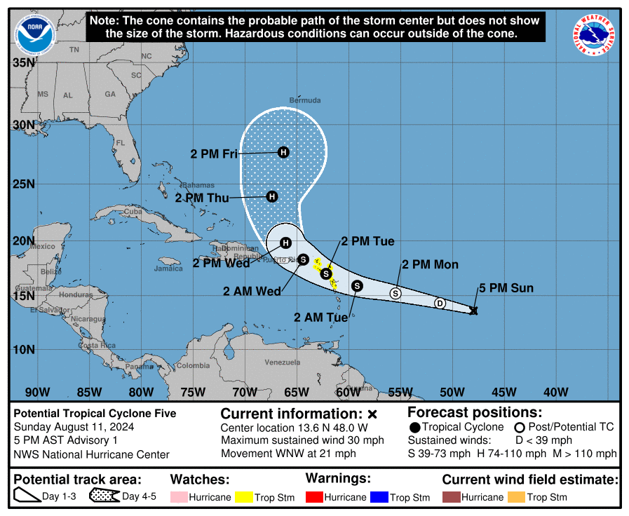
The National Hurricane Center (NHC) has initiated advisories on Potential Tropical Cyclone Five, currently located approximately 950 miles east-southeast of Antigua. As of the 4 p.m. CDT (5 p.m. AST) advisory, the disturbance is centered near latitude 13.6 North and longitude 48.0 West, with maximum sustained winds of 30 mph and a west-northwestward movement at 21 mph. The minimum central pressure is 1010 mb.
Watches and Warnings:
Tropical Storm Watches have been issued for the following areas:
– Guadeloupe
– St. Kitts, Nevis, Montserrat, Antigua, Barbuda, and Anguilla
– Saba and St. Eustatius
– St. Martin
– Sint Maarten
A Tropical Storm Watch means that tropical storm conditions are possible within the watch area, generally within 48 hours.
Interests in the British and U.S. Virgin Islands and Puerto Rico should monitor the progress of Potential Tropical Cyclone Five, as additional watches may be required tonight or early Monday.
Discussion and Outlook:
The system is currently showing some signs of organization, but a well-defined center has not yet formed. Environmental conditions are expected to become more favorable for development over the next day or two, and the system is forecasted to strengthen into a tropical storm by late Monday. The system is expected to approach the Leeward Islands on Tuesday and may impact the U.S. and British Virgin Islands by Tuesday night.
Rainfall and Wind Impacts:
– Northern Leeward Islands: Potential rainfall accumulations of 4 to 6 inches.
– Puerto Rico: Rainfall accumulations of 3 to 6 inches, with isolated maximum amounts of up to 10 inches.
– Windward Islands: 1 to 2 inches of rainfall.
– Southern Leeward Islands: 2 to 4 inches of rainfall.
– Eastern Hispaniola: 2 to 4 inches of rainfall.
Tropical storm conditions are possible within the watch areas starting Tuesday. Swells generated by the system are likely to affect portions of the Leeward Islands starting Monday night, potentially causing life-threatening surf and rip currents.
All indications are that the system will recurve out over the open Atlantic and should not affect the United States.
Forecasts for Specific Locations:
The following forecasts are based on the current track and intensity of Potential Tropical Cyclone Five and are subject to change:
St. Thomas, U.S. Virgin Islands: Potential Tropical Cyclone Five is expected to bring minor impacts to St. Thomas, with the strongest effects occurring during the early morning hours of Wednesday, August 14th. Northerly tropical storm force winds (39 MPH) are anticipated to begin around 11 PM CDT on Tuesday, with the peak intensity occurring near 4 AM CDT when sustained winds from the west could reach 53 MPH, and gusts may hit 65 MPH. Winds should decrease below tropical storm force by around 3 PM CDT, though gusts above this threshold could persist for several more hours. Minor residential wind damage is possible, particularly to porches, awnings, carports, sheds, and unanchored mobile homes. Unsecured lightweight objects may also be blown about.
St. Martin, LES: Potential Tropical Cyclone Five is expected to have a moderate impact on St. Martin, with very strong wind gusts up to 66 MPH possible. Northeasterly tropical storm force winds (39 MPH) are forecast to begin affecting the area around 2 PM CDT on Tuesday, August 13th. The peak winds are expected near 7 PM CDT, with sustained winds from the east reaching 54 MPH and gusts up to 66 MPH. Winds should decrease below tropical storm force by approximately 6 AM CDT the following morning, though gusts above tropical storm force may continue for several hours. Minor residential wind damage could occur, including damage to porches, awnings, carports, sheds, and unanchored mobile homes, with unsecured lightweight objects being blown around.
San Juan, PR: San Juan is expected to experience minor impacts from Potential Tropical Cyclone Five, with strong wind gusts up to 55 MPH possible. Northwesterly tropical storm force winds (39 MPH) are anticipated to begin around 6 AM CDT on Wednesday, August 14th. The strongest winds are expected near 11 AM CDT, with sustained winds from the west reaching 46 MPH and gusts up to 55 MPH. Winds should decrease below tropical storm force by 4 PM CDT, though gusts above tropical storm force may linger for several more hours. No significant wind damage is expected in San Juan from this system.
Next Advisory:
The next complete advisory will be issued by the NHC at 11:00 PM AST (10:00 PM CDT).
About the Author (Author Profile)
Bill Murray is the President of The Weather Factory. He is the site's official weather historian and a weekend forecaster. He also anchors the site's severe weather coverage. Bill Murray is the proud holder of National Weather Association Digital Seal #0001 @wxhistorianSubscribe
If you enjoyed this article, subscribe to receive more just like it.


