Potential Tropical Cyclone Five/Ernesto – Monday Morning Update
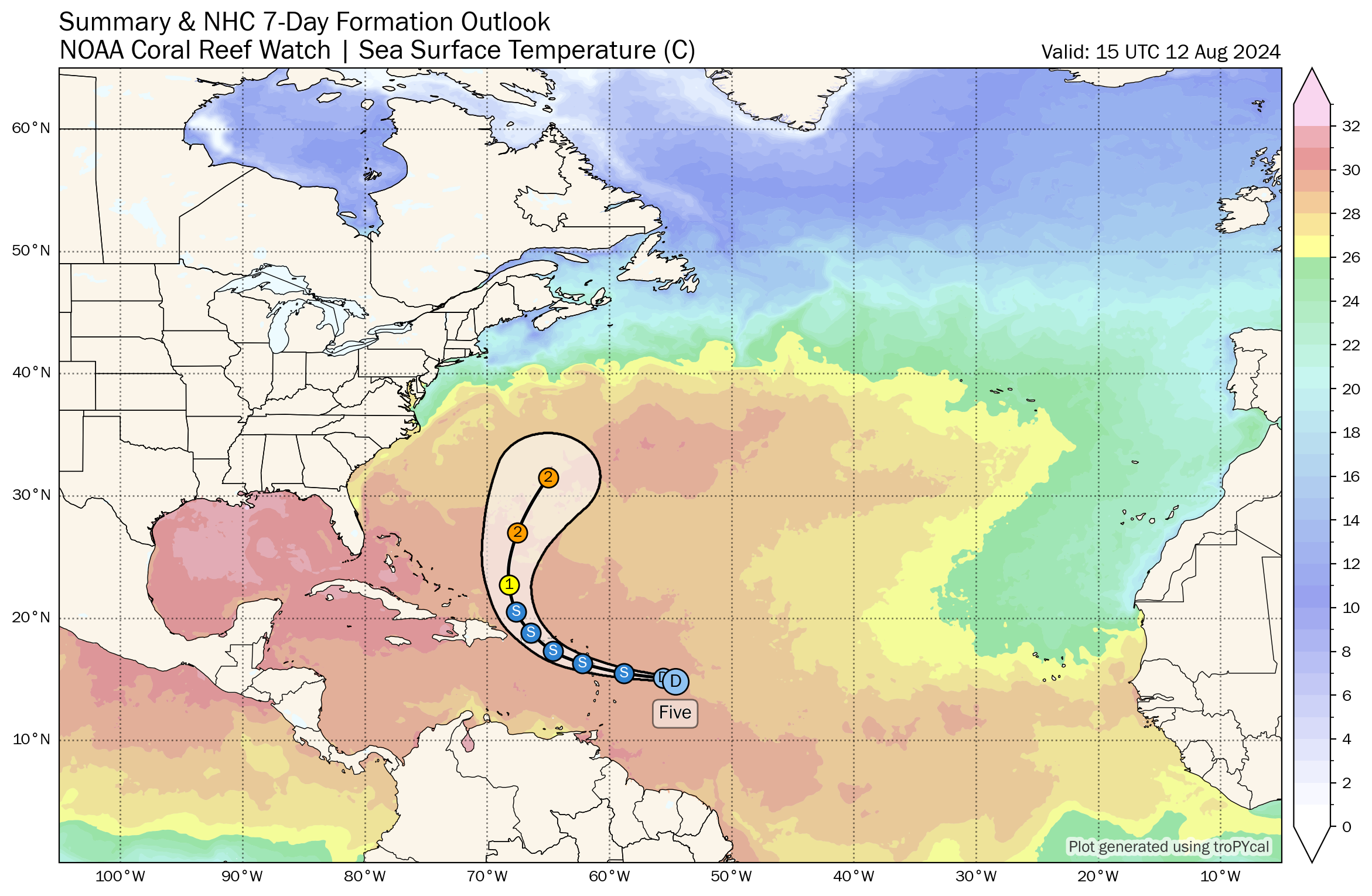
Potential Tropical Cyclone Five/Ernesto is continuing to evolve, though it remains under the influence of an unfavorable upper wind pattern, as indicated by its rapid forward movement at 30 MPH. This rapid movement suggests that the system is currently dealing with strong easterly wind shear, which is limiting its development. However, this situation is expected to change as the system moves into a more favorable environment.
Current Status and Outlook:
– Location: Approximately 435 miles east-southeast of Antigua and 730 miles east-southeast of San Juan, Puerto Rico.
– Movement: Westward at 26 MPH.
– Maximum Sustained Winds: 35 MPH.
– Central Pressure: 1010 mb.
The system is not devoid of convection, which is a positive sign for its development. However, the latest forecast now suggests that it may not become a tropical storm until early Tuesday morning. The system is expected to strengthen further, moving through the islands as a strengthening tropical storm, potentially reaching hurricane status by early Thursday as it moves north of Puerto Rico. The forecast has the system near Bermuda by Saturday morning, potentially as a strong Category 2 hurricane. While the small size of Bermuda reduces the likelihood of a direct landfall, significant impacts could still occur if the system tracks close to the island. Tropical storm force winds could begin late Friday night, with hurricane force winds potentially arriving after sunrise on Saturday.
Model Uncertainty:
– The GFS model has shown some variability, with the 0z run suggesting a more southerly track, potentially bringing the system closer to the Dominican Republic. This scenario would allow the system to track further south and westward.
– The European model has consistently delayed the system’s intensification, which aligns with the current observations of its struggle against wind shear. Some European ensembles show impacts on Nova Scotia, but none suggest a direct hit on the Eastern United States.
– The ICON model’s 0z run was well west of Bermuda, bringing the system uncomfortably close to the East Coast of the United States, near Cape Cod by next Monday morning.
Forecasts for Specific Locations:
The following forecasts are based on the current track and intensity of Potential Tropical Cyclone Five/Ernesto and are subject to change as new data becomes available:
San Juan, PR: San Juan is expected to receive a minor impact, with maximum sustained winds of 49 MPH and gusts up to 59 MPH. Northerly tropical storm force winds are anticipated to begin affecting the area on Wednesday, August 14th, at 1:00 AM CDT, peaking near 4:30 AM CDT. Winds should decrease below tropical storm force by 12:30 PM CDT.
St. Thomas, U.S. Virgin Islands: St. Thomas is expected to experience a minor impact, with maximum sustained winds of 44 MPH and gusts up to 54 MPH. Tropical storm force winds should start affecting the area on Tuesday, August 13th, at 8:00 PM CDT, with peak winds expected around 11:00 PM CDT. Winds should decrease below tropical storm force by 5:30 AM CDT on Wednesday.
St. Martin, LES: St. Martin is expected to receive a minor impact, with maximum sustained winds of 37 MPH and gusts up to 45 MPH. Easterly tropical storm force winds should start affecting the area on Tuesday, August 13th, at 3:00 PM CDT, with peak winds in the late afternoon.
Guadeloupe, LES: Guadeloupe is expected to experience a minor impact, with maximum sustained winds of 32 MPH and gusts up to 39 MPH. Tropical storm force winds are anticipated to begin on Tuesday, August 13th, at 7:00 AM CDT, peaking later in the morning.
Bermuda, UK: Bermuda could face significant impacts if the system tracks close to the island. Tropical storm force winds could begin late Friday night, with hurricane force winds potentially arriving after sunrise on Saturday, August 17th. The current forecast suggests maximum sustained winds of 60 MPH with gusts up to 73 MPH, though this is subject to change based on the system’s development and track.
IN SUMMARY
There is still some uncertainty in the exact track and intensity of Potential Tropical Cyclone Five/Ernesto, particularly concerning its potential impact on Bermuda and whether it may interact with the East Coast of the United States or Atlantic Canada. As the models continue to refine their predictions, shifts in the forecast track are possible. It’s important for all areas within the potential path of the storm to stay informed and prepared as more updates become available.
About the Author (Author Profile)
Bill Murray is the President of The Weather Factory. He is the site's official weather historian and a weekend forecaster. He also anchors the site's severe weather coverage. Bill Murray is the proud holder of National Weather Association Digital Seal #0001 @wxhistorianSubscribe
If you enjoyed this article, subscribe to receive more just like it.


