Notes at Nine: We Will Have Francine Soon
Good morning!
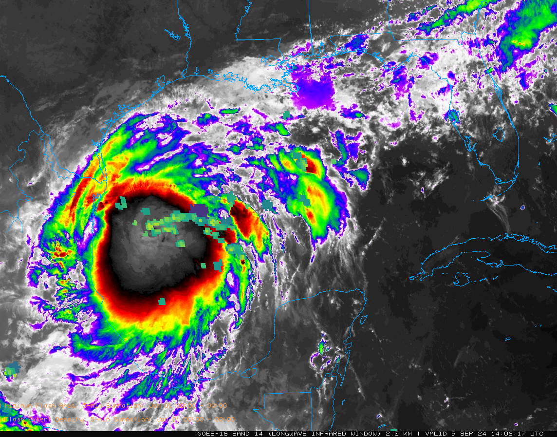
PTC Six in the western Gulf is definitely becoming better organized this morning. There is extensive convection building into a large circular pattern as evidence by very cold cloud tops with temperatures in the -70C to -90C range.
The GOES Lightning Mapper shows that lightning has become concentrated underneath the northeastern quadrant of that convection area. Those are the green and yellow block on the satellite image above.
Some banding is evident. And it seems some sort of transient center may be forming as shown by the darker area of warmer cloud tops in the northwestern quadrant of that dense convection.
Air Force Hurricane Hunters did find a decent wind center, although winds were not really strong anywhere along their path. The strongest winds are being found still along the southwestern side of the system.
Buoy 42055 is just southeast of the main circulation. The winds there are light, westerly at 12 knots gusting to 16 knots. Pressure was 29.72 inches and rising slowly as the storm moves away.
I think PTC6 will be upgraded to Tropical Storm Francine on the 10 a.m. advisory.
Rapid intensification is fairly likely later today and tomorrow. It will likely become a hurricane later today as well. There is some chance that it will become a major hurricane in the next couple of days. It will encounter some drier air as it approaches the coast which will cause it to level off or even weaken a bit. But this may be overcome by a jet structure to the northwest of the storm, which will provide additional ventilation to the system. Think Hurricane Eloise in 1975.
In addition, the storm will be moving quickly, which will help offset some of the negative environmental conditions. The storm will be traveling over 31C water today, and 30 to 29C water through landfall, which will support a strong hurricane. The oceanic heat content (related to depth of warm water) lessens with time, which means the intensification would probably level off.
But the potential is still there to have a category 2 hurricane or even a major category 3 hurricane approaching the coast.
Wednesday will feature rapidly deteriorating conditions along the Louisiana coast as the center moves toward shore. Tropical storm force winds will reach the Louisiana coast around noon on Wednesday, with strong tropical storm force winds arriving around 4 p.m. with a brief period of hurricane force winds around 7 p.m. The tropical storm force winds will continue in places like Lafayette and New Iberia until 3 a.m.
Baton Rouge will see tropical storm force winds from 7 p.m. until 7 a.m.
The strongest winds will be near and to the east of the path of the center, likely up through Opelousas and Morganza.
Our impacts in Alabama will be rain and gusty winds. 2-3 inches of rain looks likely for North and Central Alabama, which will be very beneficial.
Along the beautiful beaches of Alabama and Northwest Florida, a high rip current risk will be the problem.
I will have some city by city forecasts based on the 10 am forecast package before noon today.
Category: Alabama's Weather, ALL POSTS, Tropical
About the Author (Author Profile)
Bill Murray is the President of The Weather Factory. He is the site's official weather historian and a weekend forecaster. He also anchors the site's severe weather coverage. Bill Murray is the proud holder of National Weather Association Digital Seal #0001 @wxhistorianSubscribe
If you enjoyed this article, subscribe to receive more just like it.


