Sunday Weather Briefing Video: More Heat, Then Tropical Trouble in the Gulf
As we welcome the arrival of fall with the autumn equinox occurring this morning at 7:44 a.m. CDT, marking the moment when day and night are nearly equal in length, the weather across Alabama will feel more like summer with warm and dry conditions expected for much of the week. High pressure will keep temperatures in the low to mid-90s through Monday, well above the seasonal norm for the first days of fall. A weak cold front is expected to bring a slight cooldown and a few scattered showers by midweek, offering a hint of the cooler weather to come. This transition, while subtle, serves as a reminder that the seasons are changing, even if the warmth lingers a little longer. We’ll also be keeping a close eye on the tropics, as a potential system developing in the northwestern Caribbean could bring unsettled weather to the Gulf Coast later in the week.
A HOT SATURDAY: Temperatures were off to the races under a bright blue sky Saturday morning after comfortable morning readings. Afternoon highs were tightly clustered across Central Alabama, ranging between 92F at Troy, to 93F at Tuscaloosa and Anniston, to 94F at Birmingham, Calera and Montgomery. The 94F at Birmingham compares to a normal high for September 21st of 85F. The morning low of 64F was spot on the normal low for the date. The afternoon high was 4 degrees short of the record high for the date of 98F, set in 1925 at 2010.
MORE HEAT FOR YOUR SUNDAY: Sunday is expected to be another hot day across Central Alabama, with afternoon temperatures climbing into the low to mid-90s under mostly sunny skies. The high-pressure ridge that has dominated the region will continue to suppress cloud cover and rainfall, allowing the sun to heat up the area efficiently. Heat indices may make it feel even warmer, so those spending time outdoors should take precautions to stay hydrated and avoid prolonged exposure to the sun, especially during peak afternoon hours. Light and variable winds will provide little relief from the heat, making it a typical late summer day, even as we officially begin the fall season.
SOLIDLY INTO FALL: The beginning of the week will feature continued hot and dry conditions across Central Alabama as the high-pressure ridge remains firmly in place. Temperatures on Monday and Tuesday will once again rise into the lower 90s under mostly sunny skies, with little chance of rain. By midweek, the ridge is expected to weaken slightly, allowing for a slight increase in cloud cover and a return of isolated to scattered showers and thunderstorms by Wednesday afternoon. While rain chances remain low, any showers that develop could bring brief relief from the heat. Temperatures will stay above average, but may cool slightly, with highs in the upper 80s to around 90 degrees by Wednesday.
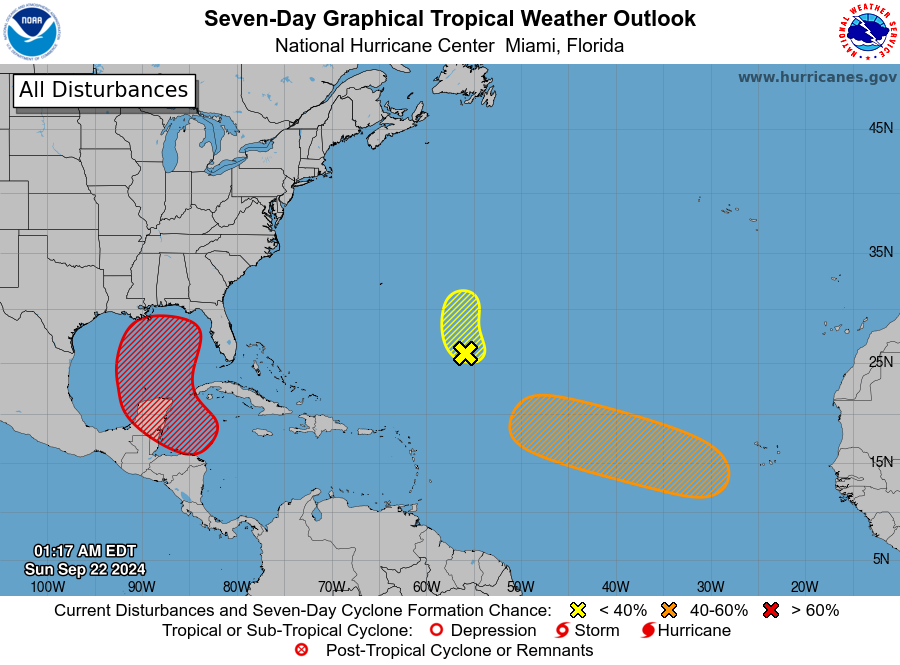
EYE ON THE NORTHWEST CARIBBEAN: A tropical disturbance in the western Caribbean is expected to develop into a tropical system early next week as it moves into the northwestern Caribbean and southern Gulf of Mexico. While models indicate a potential for this system to become a hurricane and impact the northern Gulf Coast late next week, there is still significant uncertainty regarding the exact track and intensity. Residents, property owners, and visitors to the Gulf Coast, from Louisiana to the Florida Panhandle, should closely monitor this system as it could bring heavy rain, strong winds, and storm surge impacts starting as early as Thursday and continuing into the weekend. Stay updated with official forecasts and be prepared for potential changes in the system’s path and strength.
LOOK BACK AT PTC8: Last Monday, Potential Tropical Cyclone Eight demonstrated that even without an official name, a storm can deliver devastating impacts. Over two days, areas in the Cape Fear region of southeastern North Carolina experienced between 12 and 20 inches of rain, causing severe flash flooding that washed out roads and closed highways, including sections of NC Highway 211, US 421, and US 17. The heaviest rainfall, peaking at over 20 inches in Carolina Beach, fell within a concentrated 12-hour period on September 16. Wind gusts also reached up to 77 mph at Sunny Point Military Ocean Terminal, further complicating recovery efforts. The system’s intensity and damage, particularly in Brunswick and New Hanover counties, underscore the need for vigilance even with unnamed storms.
BEACHCAST: Beachgoers along the beautiful Alabama and Northwest Florida coastlines can expect mostly sunny skies and warm temperatures in the upper 80s, with water temperatures in the mid-80s making for ideal swimming conditions. The rip current risk is low, but caution is always advised near groins, jetties, and piers. While the first part of the week looks favorable for beach plans, uncertainty remains for the latter part of the week as a potential tropical system could develop in the Gulf of Mexico. This system may bring increased winds, rain, and hazardous surf conditions, so it’s important to stay updated on the latest forecasts if you have plans later in the week.
Click here to see the Beach Forecast Center page.
ELSEWHERE IN THE TROPICS: In the tropics, the central subtropical Atlantic is being monitored for a low-pressure system situated about 700 miles southeast of Bermuda. Despite some showers and thunderstorms near its center, development chances are low due to dry environmental conditions. Meanwhile, a tropical wave expected to emerge from the coast of Africa in the next couple of days could gradually develop into a tropical depression as it moves westward across the eastern and central tropical Atlantic next week. This system has a medium chance of formation over the next seven days.
NATIONALLY: A winter weather advisory is in effect for Rocky Mountain National Park and the Medicine Bow Range, and The Mountains of Summit County, the Mosquito Range, and the Indian Peaks.in Colorado where 3-8 inches of snow is expected, generally south of I-70 and above 10,000 feet.
DANCING WITH THE STATS: The high in Waterloo, Iowa on Saturday was 93F tying the record set in 1937. 81F Saturday morning in San Juan, PR, was a record warm minimum for the date.
WEATHERBRAINS: This week, the panel will entertain a group from the Central Indiana Severe Weather Symposium. Check out the show at www.WeatherBrains.com. You can also subscribe on iTunes. You can watch the show live on our new YouTube channel for the show.You will be able to see the show on the James Spann 24×7 weather channel on cable or directly over the air on the dot 2 feed.
ON THIS DATE IN 2009: A wet month was underway in Birmingham, as the rainfall total for the month stood at 9.47 inches of rain, and the yearly total to 51.13 inches—a surplus of 10.64 inches. This heavy rainfall was due to a tropical low that moved inland from the western Gulf of Mexico on September 13th, stalling in the Ark-La-Tex region. Although it was not a named storm, its impact resembled that of a stalled hurricane, similar to Tropical Storm Alberto in 1994, which caused widespread flooding in Southeast Alabama and South Georgia. This prolonged rainfall left the ground saturated across Alabama and the broader Deep South. Meanwhile, west of Atlanta, catastrophic flooding resulted in nine fatalities, many of them in vehicles swept away by floodwaters. The flooding inundated areas like Six Flags Over Georgia, highlighting the severe impacts of the relentless rain on the region. Follow my weather history tweets on Twitter. I am @wxhistorian at Twitter.com.
Category: Alabama's Weather, ALL POSTS, Tropical
About the Author (Author Profile)
Bill Murray is the President of The Weather Factory. He is the site's official weather historian and a weekend forecaster. He also anchors the site's severe weather coverage. Bill Murray is the proud holder of National Weather Association Digital Seal #0001 @wxhistorianSubscribe
If you enjoyed this article, subscribe to receive more just like it.


