Quick look
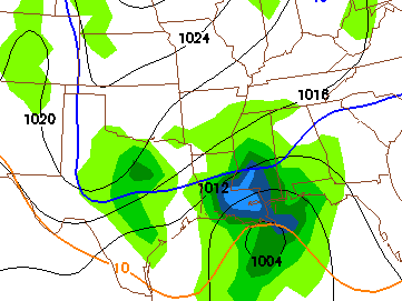
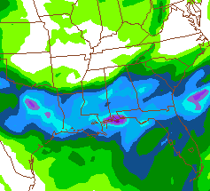
The storm system coming through Monday night and Tuesday is very interesting. The NAM and GFS show that a low pressure area will develop in the northern Gulf of Mexico, and be on or just slightly SE of the classic track for snowfall in central Alabama. However, the GFS keeps most of the deeper moisture south of Clanton, while the NAM brings heavy precipitation (0.5 to 1.0 inches of liquid equivalent) as far north as TCL/BHM/ANB. If all that were to be in the form of snow (unlikely), and stick (unlikely), it would be 5-10″ (almost impossible). Both models show low-level temperatures cold enough for most of the precipitation to be snow, especially once it falls for a while. However, the NAM shows temperatures reaching the lower 50s Monday afternoon, and even falling snow having a hard time lowering the temperature 20 degrees.
No way to call amounts of snow right now, with models being so different and the surface temperatures possibly being too warm for accumulation through some of the event. It does look like parts of Alabama will see a mixture of rain and snow Monday night and Tuesday. How far north the warmer air can return before the next system comes in will help determine the track of the low, so we’ll see more tomorrow. The GFS is colder but farther south, and the NAM is warmer but farther north. Someone will be in the sweet spot for snow.
Category: Uncategorized


