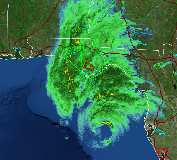
4PM CDT Update: Comprehensive Look at Helene as it Quickly Approaches the Florida Coast
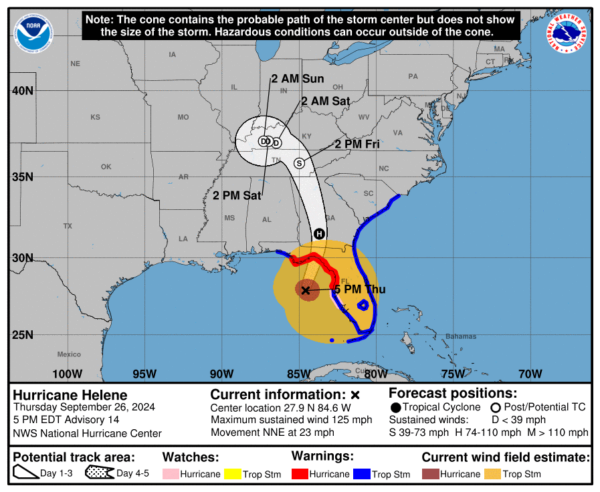
We are getting very close to the landfall of Helene. The storm is currently located 175 miles south of Tallahassee moving at a speed of 23 mph. Landfall should occur within the next 5-6 hours. With their 4PM CDT update, the National Hurricane Center has provided some troubling updates.
Here are the current facts from the NHC:
SUMMARY OF 500 PM EDT…2100 UTC…INFORMATION
———————————————-
LOCATION…27.9N 84.6W
ABOUT 130 MI W OF TAMPA FLORIDA
ABOUT 175 MI S OF TALLAHASSEE FLORIDA
MAXIMUM SUSTAINED WINDS…125 MPH
PRESENT MOVEMENT…NNE AT 23 MPH
MINIMUM CENTRAL PRESSURE…951 MB…28.09 INCHES
IMPORTANT UPDATES:
1. The most notable update is the maximum wind speed of 125 mph. Category 4 status is reached at 130 mph, and Helene is very close to that. Unfortunately, the storm still has plenty of time to continue strengthening before it hits the Florida Coast. The NHC notes that Helene will likely be a category 4 hurricane at landfall.
2. Hurricane force winds are extending 60 miles outwards from the low pressure center, and tropical storm force winds are being recorded up to 310 miles from the center. At landfall, it is likely that very strong winds will be felt all across the Big Bend region, especially in the areas nearby the location of landfall.
3. Helene is moving very quickly at 23 miles per hour. After landfall, the storm will begin to dramatically weaken, but will hold onto its hurricane status as it moves inland due to its fast motion. This means that areas beyond the Florida Coast will be met with hurricane force winds.
4. The minimum pressure has dropped to 951 mb.
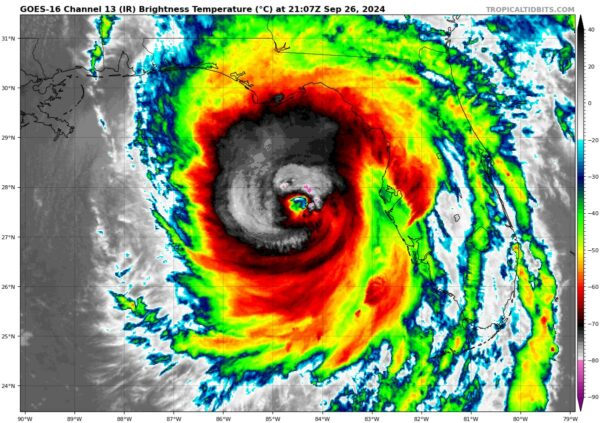
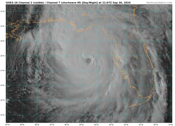
5. The eyewall has become completely closed, and is beginning to clear out. Unfortunately, this is a sign of a very healthy hurricane. As of right now, there are not many factors that will work to challenge the storm’s strength before landfall.
6. The storm is set to make a northward turn after landfall, going north through Georgia before stalling over the Tennessee Valley.
As noted by the NHC: “If you live in this area and were told to evacuate by local officials, your opportunity to do so is almost over.”
HURRICANE TRACK:
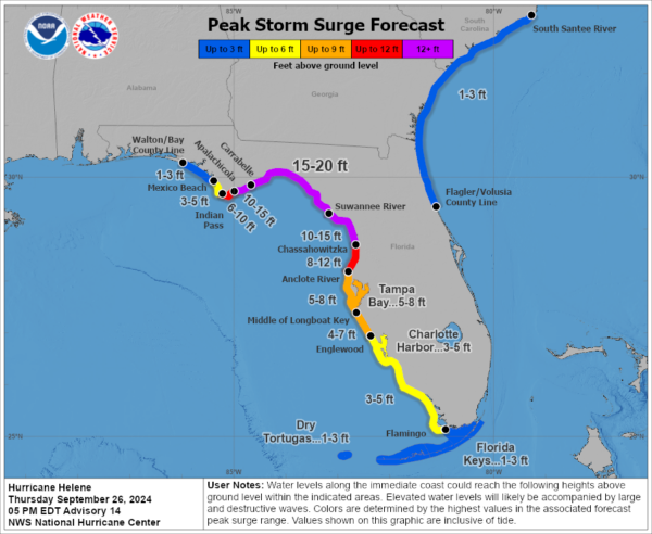
STORM SURGE:
Forecasted storm surge totals remain the same as this morning. 15-20 ft surge is expected in and around the location of landfall (Apalachicola to Chassahowitzka). Lower, but still dangerous, levels of surge are expected for most of the rest of the Florida Coast.
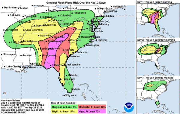
FLOODING:
Flooding concerns also remain similar to this morning. Areas with the highest risk of flash flooding include: Panama City Beach to Tallahassee, FL, and areas north of these locations including Atlanta, and the Appalachia Region.
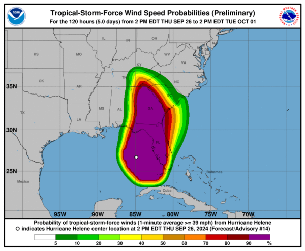
WINDS:
Almost the entire state of Florida, and the entire state of Georgia will feel tropical storm force winds or higher (greater than 39 mph). This wind field is somewhat uncommon, even for a stronger hurricane, and is due to the fast speed at which Helene will be moving inland.
TORNADOES:
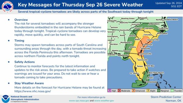
The tornado threat remains the same as it was in earlier updates. Here is a graphic explaining timing and locations:
Note that many areas in Florida, Georgia, and South Carolina are currently under a tornado watch. Tornado-warned storms have also been popping up all day long and will continue to do so into the nighttime hours.
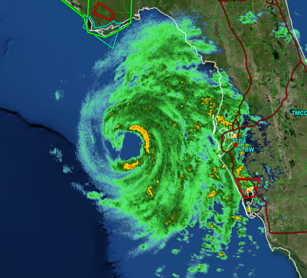
RADAR AND SATELLITE IMAGES:
Here is Helene as seen by the Tampa Radar Site:
And here is another view from the Tallahassee Radar Site:
Category: ALL POSTS, Social Media, Tropical

