PDS Tornado Watch Issued Back to Our West
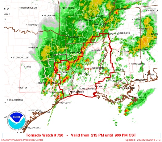
The National Weather Service Storm Prediction Center has issued Tornado Watch Number 720. This watch is in effect until 9:00 PM CST this evening for portions of southeast Arkansas, central and southwest Louisiana, southwest Mississippi, southeast Texas, and nearby coastal waters. This is a Particularly Dangerous Situation, folks—one we don’t take lightly.”
The primary threats within this watch area include:
Numerous tornadoes, with a few likely to be strong and long-lasting.
Widespread damaging winds, with gusts that could reach up to 80 mph.
Scattered large hail, with isolated hailstones as large as 2 inches in diameter possible.
The Situation:
Severe thunderstorms, including supercells, are intensifying rapidly this afternoon over east Texas and western Louisiana. These storms are expected to spread northeastward through the evening hours. Conditions in the atmosphere are becoming increasingly favorable for tornadoes, including the potential for strong, long-track tornadoes. Widespread damaging winds will also be a significant concern as this system evolves.
Category: ALL POSTS, Severe Weather
About the Author (Author Profile)
Scott Martin is an operational meteorologist, professional graphic artist, musician, husband, and father. Not only is Scott a member of the National Weather Association, but he is also the Central Alabama Chapter of the NWA president. Scott is also the co-founder of Racecast Weather, which provides forecasts for many racing series across the USA. He also supplies forecasts for the BassMaster Elite Series events including the BassMaster Classic.Subscribe
If you enjoyed this article, subscribe to receive more just like it.


