Thunder Across South Central Alabama This Afternoon, Rain Else Over Central Alabama
It was so nice to wake up to long, low rumbles of thunder across Central Alabama this morning as a couple of areas of rain and embedded thunder moved across the area.
WIDESPREAD RAIN AND A FEW STRONG STORMS CONTINUE THIS AFTERNOON
A large area of moderate rain is covering much of central Alabama early this afternoon, with embedded heavier showers and isolated thunderstorms. A strong storm earlier prompted a significant weather advisory for Choctaw County, with radar indicating winds over 30 mph and pea-sized hail. That same storm intensified and prompted a severe thunderstorm warning in Clarke County, Mississippi. Nickel sized hail was reported near Quitman in Clarke County. While widespread severe weather is not expected today, a few storms could still produce small hail and gusty winds, especially south of the Highway 80 corridor, including areas like Montgomery, Auburn, and Demopolis.
COOL AND DAMP CONDITIONS DOMINATE CENTRAL ALABAMA
Despite being early March, temperatures remain chilly across much of the state due to cloud cover and rain-cooled air. As of midday, readings range from the mid-40s in Birmingham to the upper 50s in Montgomery. While rain coverage may decrease slightly later in the afternoon, periods of showers will persist through tonight as an upper-level disturbance lingers over the region.
UNSETTLED PATTERN THIS WEEK…BUT WARMER
A cool and unsettled weather pattern will dominate the upcoming week across central Alabama, starting with lingering showers and cloudy skies on Monday as an upper-level low exits the region. Highs will reach the mid to upper 60s by the afternoon, with drier air gradually filtering in. Skies will clear Monday night, setting up a stretch of pleasant and dry weather Tuesday and Wednesday, with highs climbing into the low to mid-70s. A weak system will bring a chance for scattered showers and a few thunderstorms Wednesday night into Thursday, mainly across the southern half of the state, but any rainfall amounts will be light. A more significant storm system arrives late Friday into Saturday, with increasing rain and thunderstorm chances. Models continue to highlight strong wind shear and a broad warm sector, suggesting a potential for severe storms Saturday afternoon into Sunday morning. Temperatures will remain mild throughout the period, with highs reaching the upper 70s to near 80 by the end of the week.
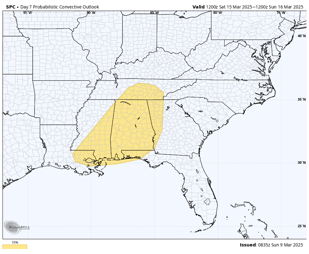
Level 2 of 5 risk for next Saturday afternoon and night across Alabama and the South
NEXT WEEKEND’S SEVERE WEATHER THREAT
Looking ahead, confidence is increasing in a potent storm system that will impact Alabama next weekend. The Storm Prediction Center has placed portions of the state under a Level 2 out of 5 risk for severe storms, with the current timing focused on Saturday afternoon through Sunday morning. While details will become clearer in the coming days, this system will have the potential to produce damaging winds, tornadoes, and heavy rainfall. Forecast updates will be issued frequently through the week, with partner emails increasing in frequency starting Wednesday.
Category: Alabama's Weather, ALL POSTS, Severe Weather, Social Media
About the Author (Author Profile)
Bill Murray is the President of The Weather Factory. He is the site's official weather historian and a weekend forecaster. He also anchors the site's severe weather coverage. Bill Murray is the proud holder of National Weather Association Digital Seal #0001 @wxhistorianSubscribe
If you enjoyed this article, subscribe to receive more just like it.


