Update on the Alabama Weather Situation at 7:30 pm
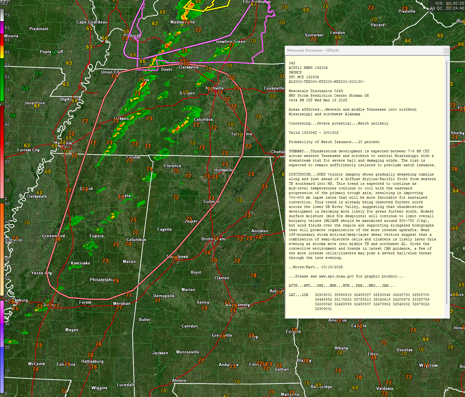
CURRENT RADAR AND STORM DEVELOPMENT
Radar imagery shows developing showers and thunderstorms across southern Tennessee, northwest Alabama, and northern Mississippi. These extend from west of Columbia, Tennessee, to east of Tupelo, Mississippi, down to near Kosciusko, Mississippi. A more developed cluster of showers is near Jackson, Tennessee. Two separate lines of storms appear to be forming, with one more concentrated in Tennessee and another building across Mississippi into Alabama.
SEVERE WEATHER THREAT
The primary hazards tonight include strong wind gusts between 40 and 50 mph, hail up to quarter size, and heavy rainfall. The tornado risk is near zero. The Storm Prediction Center maintains a marginal risk, or level one of five, for severe storms across Alabama. Tornado watches and severe thunderstorm watches are in effect to the north, but the SPC does not anticipate issuing a watch for Alabama at this time. Heavy rainfall could lead to localized ponding on roads.
TIMING AND IMPACTS FOR NORTH AND CENTRAL ALABAMA
Storms will increase in coverage through the evening, remaining mainly west of I-65 and north of I-20 through 10 pm. Storms will approach the Tuscaloosa and Birmingham areas between 10-11 pm and Gadsden and Anniston by midnight. The storms will be east of Tuscaloosa and Birmingham by 1 am. Strong storms will progress down I-65 through 3 am, passing east of Montgomery by 330 am. The storms should be pretty much through by 4 am, and much cooler, drier air settles in across the state after sunrise.
THE METEOROLOGICAL SETUP
A cold front moving into Alabama is interacting with a narrow band of moisture return from the Gulf. However, limited low-level moisture and weak instability, generally between 500 and 750 joules per kilogram of CAPE, are keeping storm intensity somewhat limited. The upper-level disturbance over the Ohio Valley is driving this system, with a surface trough and Pacific front triggering storms. Wind shear between 40 and 50 knots supports storm organization, but without stronger instability, storms may struggle to sustain severe levels.
BEHIND THE FRONT
Cold air rushes in Thursday, with northwest winds gusting up to 25 to 30 mph. Highs will struggle to reach 50 degrees in the north and the low 50s in the south. A freeze watch is in effect for much of north Alabama Thursday night, with lows in the upper 20s to low 30s.
SAFETY REMINDERS
Multiple ways to receive warnings should be in place, including weather radios, smartphone apps, and local media. Loose outdoor objects should be secured before strong winds arrive. Driving in heavy rain should be avoided, and motorists should watch for water ponding on roads. If a severe thunderstorm warning is issued, move to a sturdy building away from windows, preferably on the lowest floor.
BOTTOM LINE
Severe storms remain possible tonight, mainly across northwest and north-central Alabama, with the main threats being damaging winds, and hail. Conditions improve quickly by Thursday morning, with colder air and gusty winds moving in behind the front.
Category: Alabama's Weather, ALL POSTS, Severe Weather, Social Media
About the Author (Author Profile)
Bill Murray is the President of The Weather Factory. He is the site's official weather historian and a weekend forecaster. He also anchors the site's severe weather coverage. Bill Murray is the proud holder of National Weather Association Digital Seal #0001 @wxhistorianSubscribe
If you enjoyed this article, subscribe to receive more just like it.


