Flash Flood Warning for Parts of Franklin, Colbert and Lawrence Counties
3-4 inches of rain have fallen across parts of the warning area.
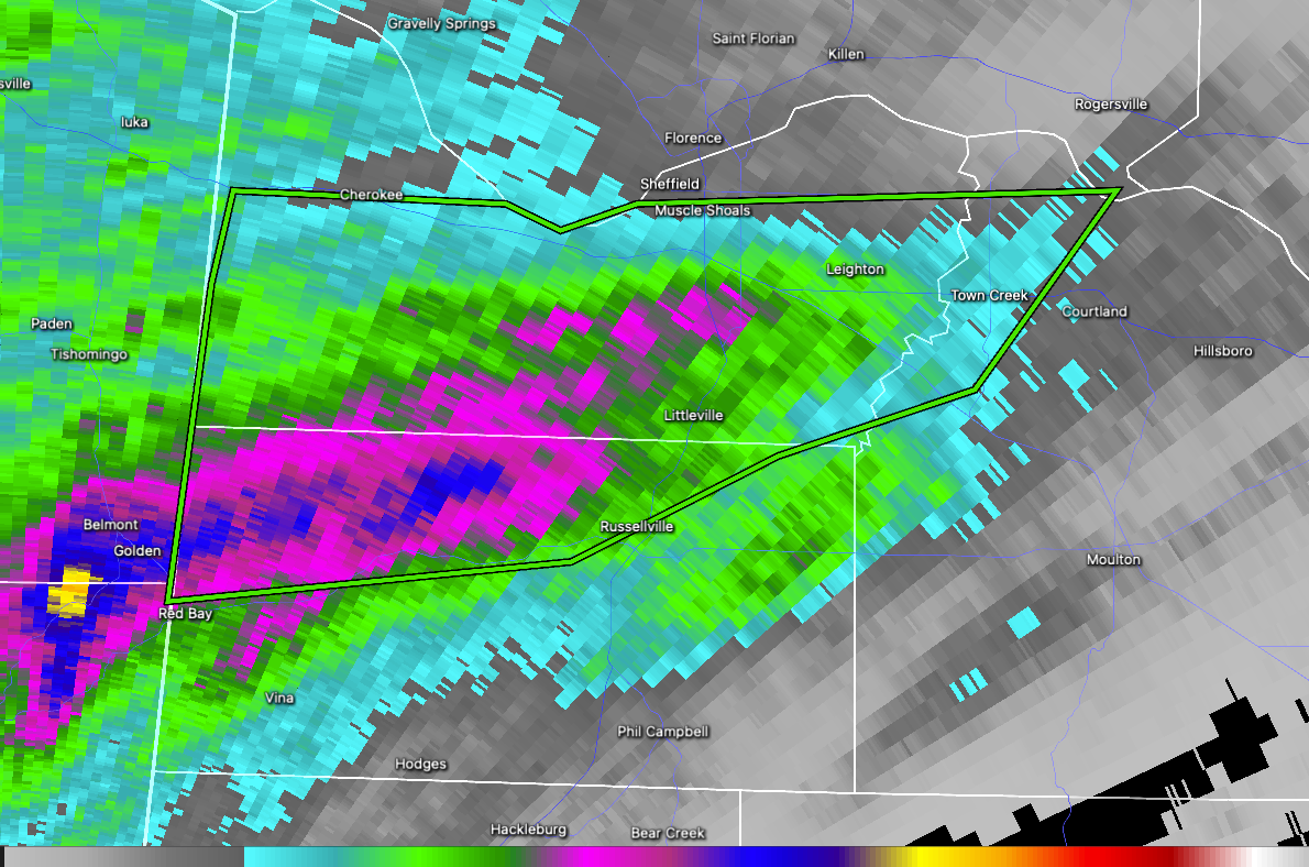
BULLETIN – EAS ACTIVATION REQUESTED
Flash Flood Warning
National Weather Service Huntsville AL
513 AM CDT Mon Mar 31 2025
The National Weather Service in Huntsville has issued a
* Flash Flood Warning for…
Colbert County in northwestern Alabama…
Northwestern Franklin AL County in northwestern Alabama…
Northwestern Lawrence County in northwestern Alabama…
* Until 1115 AM CDT Monday.
* At 513 AM CDT, Doppler radar indicated thunderstorms producing
heavy rain across the warned area. Between 1 and 3 inches of rain
have fallen. Additional rainfall amounts of 1 to 2 inches are
possible in the warned area. Flash flooding is ongoing or expected
to begin shortly.
HAZARD…Flash flooding caused by thunderstorms.
SOURCE…Radar.
IMPACT…Flash flooding of small creeks and streams, urban
areas, highways, streets and underpasses as well as
other poor drainage and low-lying areas.
* Some locations that will experience flash flooding include…
Muscle Shoals, Russellville, Sheffield, Tuscumbia, Red Bay, Town
Creek, Cherokee, Littleville, Leighton, Belgreen, New Bethel,
Crooked Oak, Posey Loop, Red Rock, Colbert Heights, Pride Landing,
Srygley Church, Barton, Cedar Creek Reservoir and Dempsey.
PRECAUTIONARY/PREPAREDNESS ACTIONS…
Turn around, don’t drown when encountering flooded roads. Most flood
deaths occur in vehicles.
&&
LAT…LON 3476 8810 3475 8785 3473 8780 3475 8773
3476 8729 3461 8742 3456 8760 3448 8779
3445 8816 3469 8812
FLASH FLOOD…RADAR INDICATED
Category: Alabama's Weather, ALL POSTS, Severe Weather
About the Author (Author Profile)
Bill Murray is the President of The Weather Factory. He is the site's official weather historian and a weekend forecaster. He also anchors the site's severe weather coverage. Bill Murray is the proud holder of National Weather Association Digital Seal #0001 @wxhistorianSubscribe
If you enjoyed this article, subscribe to receive more just like it.


