Severe Thunderstorm Warning Issued for Macon County Until 2:15pm
The NWS has issued a severe thunderstorm warning for Macon County until 2pm. The main hazard with this storm is damaging, 60mph wind gusts, but a tornado is possible with this storm. The NWS notes this possibility in their warning, so please be vigilant if you are within this warning.
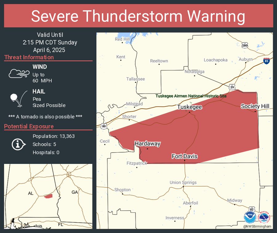
The National Weather Service in Birmingham has issued a

* Severe Thunderstorm Warning for...
  Macon County in southeastern Alabama...

* Until 215 PM CDT.

* At 108 PM CDT, a severe thunderstorm was located near Hardaway, or
  13 miles south of Milstead, moving northeast at 40 mph.

  HAZARD...60 mph wind gusts.

  SOURCE...Radar indicated.

  IMPACT...Expect damage to roofs, siding, and trees.

* Locations impacted include...
  Cross Keys, Creek Stand, Hardaway, Liverpool, Warriorstand,
  Tuskegee, Davisville, Society Hill, Lake Tuskegee, and Fort Davis.

PRECAUTIONARY/PREPAREDNESS ACTIONS...

Remain alert for a possible tornado! Tornadoes can develop quickly
from severe thunderstorms. If you spot a tornado go at once into the
basement or small central room in a sturdy structure.

For your protection move to an interior room on the lowest floor of a
building.

A Tornado Watch remains in effect until 600 PM CDT for south central,
southeastern and east central Alabama.
Category: Alabama's Weather, ALL POSTS, Severe Weather, Social Media
About the Author (Author Profile)
Scott is a senior at Mississippi State University studying professional and broadcast meteorology.Subscribe
If you enjoyed this article, subscribe to receive more just like it.


