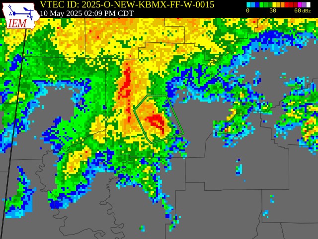
Flash Flood Warning For Tuscaloosa County Until 5:15pm
The National Weather Service in Birmingham has issued a

* Flash Flood Warning for...
  Southwestern Tuscaloosa County in west central Alabama...

* Until 515 PM CDT.

* At 207 PM CDT, Doppler radar indicated thunderstorms producing
  heavy rain across the warned area. Flash flooding is ongoing or
  expected to begin shortly.

  HAZARD...Flash flooding caused by thunderstorms.

  SOURCE...Radar.

  IMPACT...Flash flooding of small creeks and streams, urban
           areas, highways, streets and underpasses as well as
           other poor drainage and low-lying areas.

* Some locations that will experience flash flooding include...
  Tuscaloosa, Northport, Holt, Coker, Tuscaloosa Amphitheater,
  Bryant Denny Stadium, University Mall, Tuscaloosa Regional
  Airport, McFarland Mall, Shelton State Community College,
  University Of Alabama Quad, Stillman College, Oliver Lock And Dam,
  Palmore Park, Taylorville, Flatwoods, Lake Tuscaloosa Dam,
  Englewood, Sexton Bend and Little Sandy.

PRECAUTIONARY/PREPAREDNESS ACTIONS...

Turn around, don't drown when encountering flooded roads. Most flood
deaths occur in vehicles.

Be aware of your surroundings and do not drive on flooded roads.
Category: Alabama's Weather, ALL POSTS, Social Media
About the Author (Author Profile)
Jack is a junior at Mississippi State University studying meteorology. He has several years of forecasting experience through a local group of forecasters in Maryland where he resides. Jack plans to become a broadcast meteorologist after graduation.Subscribe
If you enjoyed this article, subscribe to receive more just like it.


