Storms Continue Across Alabama With Isolated Severe Threat
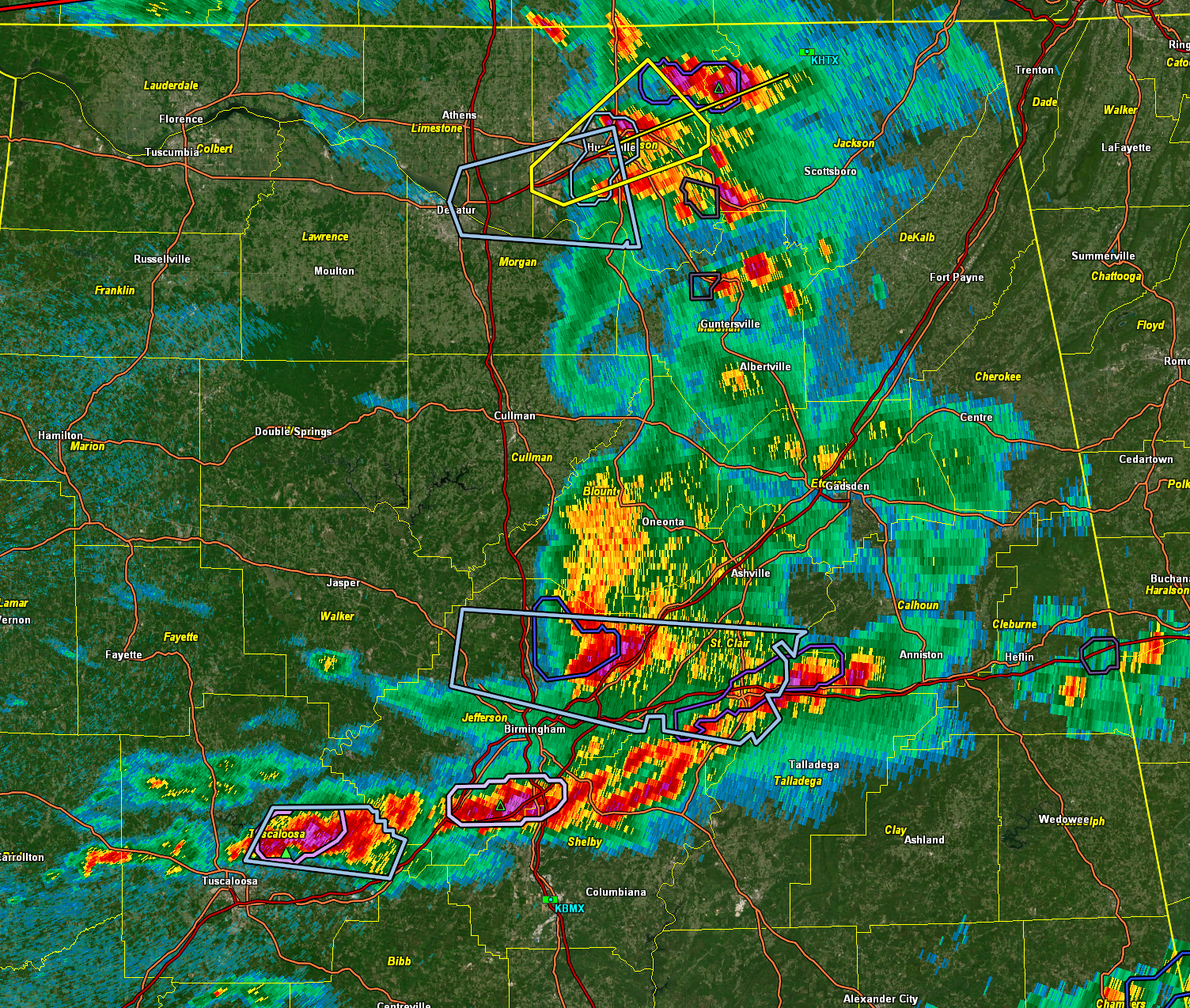
A complex of thunderstorms continues to push eastward across Alabama early this afternoon. The strongest activity is currently focused in the Huntsville area, where a severe thunderstorm warning remains in effect for central Madison County until 2:15 PM. The storm over the city is producing wind gusts to 60 mph and quarter-size hail, along with intense lightning and heavy rainfall. This system is moving east at 35 mph and will impact areas including Brownsboro, Alabama A&M University, and Moores Mill.
Further south, strong to marginally severe storms are affecting parts of North Central Alabama. A significant weather advisory is in effect for northeastern Jefferson and central St. Clair counties as a strong storm moves east at 55 mph. Gusts to 40 mph are possible along with heavy rain and cloud-to-ground lightning. This activity is part of a broader cluster that extends across much of the Birmingham metro area, with storms moving from McCalla through Hoover and along I-459 toward northern Shelby County. Some of these cells could produce small hail and gusty winds. In fact, some very small hail has been reported in Hoover.
A strengthening storm is also being tracked near Tuscaloosa, where some small hail may occur. Meanwhile, a developing thunderstorm near Eutaw in Greene County is showing signs of growth as it heads east. These storms are forming in a very warm, humid air mass where surface-based CAPE values are between 2000 and 3000 J/kg. Although widespread severe weather is not expected, a few stronger storms could still produce damaging winds or hail, especially in the western and central portions of the state.
Upper-level support is relatively modest, with weak zonal flow in place, but some shear remains present, particularly in the western half of the state. That will continue to support organized thunderstorm clusters, particularly through mid to late afternoon. Rain chances will diminish this evening as instability wanes and the shortwave impulse exits. Lingering storms could still pop up in the more humid zones near any surface boundaries, but overall coverage will be lower.
The current round of storms comes ahead of a more organized severe weather threat expected Tuesday evening, when a stronger system brings a marginal to slight risk of damaging winds, hail, and possibly tornadoes across parts of Central Alabama. The highest risk will be along and northwest of the I-85 corridor. Until then, periods of scattered storms will continue, especially during the afternoon and evening hours.
Category: ALL POSTS, Severe Weather, Social Media
About the Author (Author Profile)
Bill Murray is the President of The Weather Factory. He is the site's official weather historian and a weekend forecaster. He also anchors the site's severe weather coverage. Bill Murray is the proud holder of National Weather Association Digital Seal #0001 @wxhistorianSubscribe
If you enjoyed this article, subscribe to receive more just like it.


