Active Weather With the Potential of Strong to Severe Storms
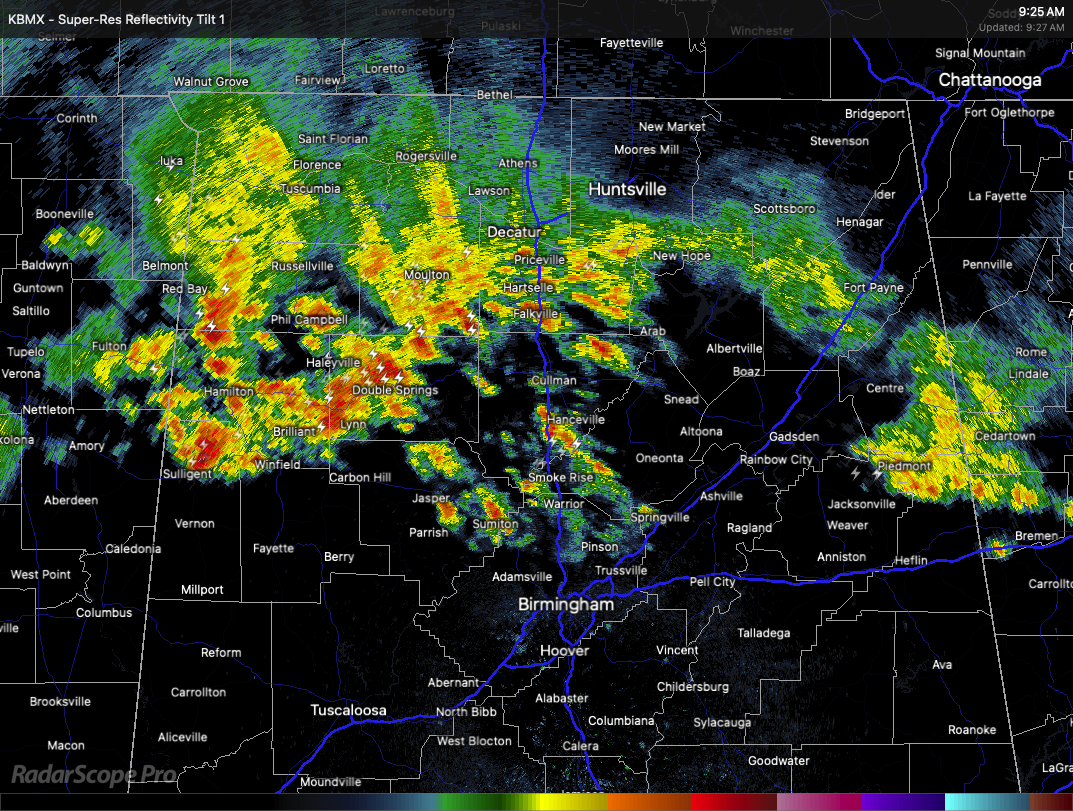
As of 9:25 AM, rain and thunderstorms are affecting the northern portion of Alabama, primarily across the northwest and north-central parts of the state. Thunderstorms with frequent lightning and moderate to heavy rain are ongoing across Colbert, Franklin, Lauderdale, Marion, Winston, Fayette, and Lamar counties. Cities such as Tuscumbia, Muscle Shoals, Russellville, Phil Campbell, Hamilton, Brilliant, Winfield, Haleyville, Double Springs, Sulligent, and Vernon are seeing the most active weather at this time.
Lighter showers with some embedded thunder are present over portions of Lawrence, Morgan, Limestone, Madison, Jackson, and DeKalb counties. This includes the cities of Moulton, Decatur, Athens, Huntsville, Scottsboro, and Fort Payne. The precipitation is less intense in these areas, with primarily light rain and occasional lightning.
Just south of the main storm activity, areas such as Walker, Cullman, Blount, and Etowah counties are seeing spotty light showers or virga, with communities like Jasper, Sumiton, Cullman, Oneonta, Cleveland, Gadsden, and Rainbow City under mostly light rain or drizzle.
Farther south, areas including Jefferson County and the Birmingham metro remain mostly dry for now, but showers and storms are approaching from the northwest. Tuscaloosa County is also dry at the moment, although rain is nearby in adjacent counties. Storms are generally moving from the west to the east-northeast and could affect more of north-central Alabama later this morning.
We’re getting into one of those active MCS-style weather patterns where waves of stoms will invade from the northwest. Also, storms could pop up just about any afternoon or evening. Today, Sunday, and Monday all carry a low-end risk of severe thunderstorms. While widespread severe weather isn’t expected, a few storms could pack a punch with strong winds and maybe some hail. Just something to keep in mind if you’ve got outdoor plans.
Now looking ahead into next week, things stay unsettled. We’re talking about a pretty active setup, with a decent chance of showers and thunderstorms each day — around a 50 to 80 percent chance depending on the day. And just like this weekend, any stronger storms that do manage to develop could bring damaging wind gusts and some hail. This is going to be more of a day-by-day forecast, depending on where boundaries set up and how the atmosphere recharges.
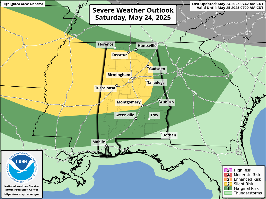
As for today, we’ve already seen one batch of storms rolling in from the northwest early this morning. That’s part of a complex of storms, what we call an MCS, coming out of northeast Arkansas. There’s a stalled front in the area, and depending on how far north that front lifts, that will determine where the morning storms go. As they move farther away from the front, we expect them to weaken a bit. But as the sun heats things up this afternoon, we could see new storms fire up along leftover outflow boundaries. The Storm Prediction Center has placed parts of the area under a Level 2 out of 5 risk today, which just means there’s a slightly better chance of a few stronger storms. Again, the main concern will be strong, gusty winds and hail.
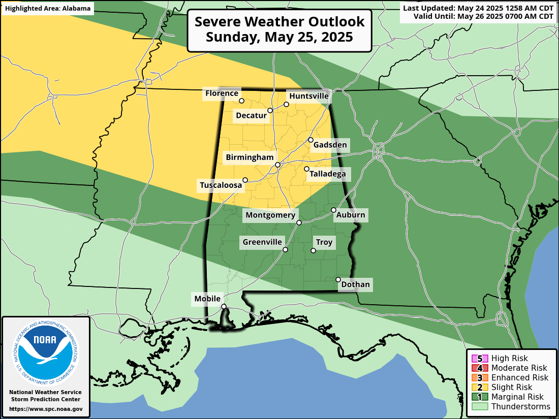
And it looks like we’ll do it all over again Sunday. Another batch of storms is expected to move in from the northwest, and just like today, we’re looking at that same slight risk setup. Strong winds and hail are once again the main threats. So if you’ve got outdoor plans this weekend, make sure you stay weather aware and keep an eye on the radar.
Category: Alabama's Weather, ALL POSTS, Severe Weather
About the Author (Author Profile)
Scott Martin is an operational meteorologist, professional graphic artist, musician, husband, and father. Not only is Scott a member of the National Weather Association, but he is also the Central Alabama Chapter of the NWA president. Scott is also the co-founder of Racecast Weather, which provides forecasts for many racing series across the USA. He also supplies forecasts for the BassMaster Elite Series events including the BassMaster Classic.Subscribe
If you enjoyed this article, subscribe to receive more just like it.


