Sunday Weather Briefing Video: May’s Magic, Storms and All
Weekend mornings in May have a way of reminding us why we love this time of year. Saturday morning was a perfect example—sunshine against a haze spring sky, temperatures sat comfortably in the lower 70s, and the green grass and blooming flowers painted the kind of scene that feels like a fresh start. There’s something timeless and renewing about mornings like that. But May in Alabama doesn’t come without its caveats, and those same mornings can foreshadow afternoon storms. We saw both sides of the coin on Saturday, and Sunday may bring even more action. A good example of how seriously that weather is being taken—first pitch of the SEC Baseball Tournament Championship at the Hoover Met has been moved up from 2 pm to 12 noon. It’s Ole Miss versus Vandy, and they’ll be racing the storms.
SATURDAY RECAP
A complex start to Saturday featured morning storms over North Alabama that left behind an outflow boundary across South Central Alabama. That boundary fired up a round of severe thunderstorms during the early afternoon, prompting a few severe thunderstorm warnings. Despite the warnings, there were no official severe reports—until later in the evening, when a storm in Marengo County produced quarter-size hail about three miles south-southeast of Demopolis around 6:30 PM. That storm continued southeast through the evening, dropping torrential rain, frequent lightning, hail, and gusty winds. Still, many across the state enjoyed a pleasant day, with seasonable temperatures and a healthy dose of sunshine.
STORMY PATTERN LOCKED IN
We remain under a northwesterly flow pattern aloft, with shortwave disturbances riding the upper-level winds toward Alabama. One of those disturbances will arrive Sunday, and like Saturday, we’ll likely see scattered to numerous showers and storms develop, especially during the afternoon and evening hours. There’s plenty of moisture in place and enough instability to support some strong to severe storms, particularly across the western and southwestern parts of the state. A stalled front draped across the region will serve as a focus for storm development through the day. Most places will reach the 80s before storms arrive.
SEVERE WEATHER OUTLOOK FOR SUNDAY
The Storm Prediction Center has much of Central Alabama under a marginal (level 1 of 5) severe risk today, with a slight (2 of 5) risk brushing portions of the northwest. Storms will be capable of producing damaging winds and hail during the afternoon and evening hours. The greatest threat looks to be tied to any organized clusters or short-lived supercells that can tap into the modest shear and instability in place.
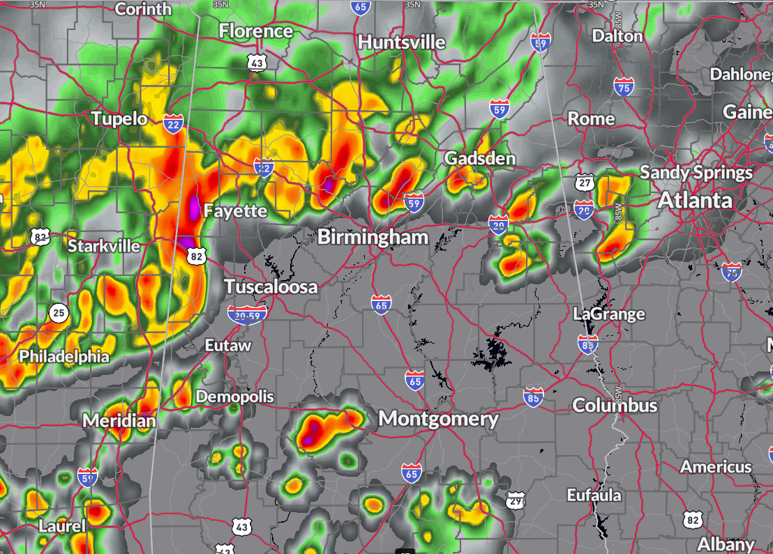
Radar depiction fro 10 pm Sunday evening from the HRRR Model
SUNDAY NIGHT AND MEMORIAL DAY
Sunday night’s storms should fade late, but another round is possible Monday as another shortwave slides through. Storm coverage will increase again in the afternoon and evening, and there is once again the potential for strong to severe storms. The severe threat is similar to Sunday—hail and damaging winds being the main concerns—but with slightly better instability Monday afternoon, a couple of storms could be more robust. Memorial Day won’t be a complete washout, but outdoor activities will need contingency plans. Expect highs in the mid to upper 80s with storms favoring the second half of the day.
WET WEEK AHEAD
The pattern continues active through the upcoming week. Westerly upper flow will keep a parade of disturbances moving across the Deep South. A stalled frontal boundary may wobble north and south through the state, adding to the instability and lift. Rain and thunderstorms are expected most days through Friday, though there will be breaks. Some of the rain could be heavy, especially if training storms develop. By week’s end, rainfall totals of 2 to 4 inches are expected across much of Central Alabama, with isolated higher amounts. Localized flooding may become a concern.
EYEING NEXT WEEKEND
Into next weekend, long-range models suggest the persistence of this unsettled pattern. With moisture still in place and weak upper disturbances lingering, at least scattered showers and storms will remain possible each afternoon. There may be a slow improvement by late Sunday or Monday, but confidence is low at this point. Daytime highs will stay near normal, mostly in the lower to mid 80s.
VOODOO TERRITORY
As we look into the week two period, the large-scale pattern doesn’t change much. Upper-level ridging tries to build across the western U.S., while a broad trough dominates the eastern half of the country. That setup keeps our region in the path of frequent disturbances, meaning continued elevated rain chances and near or slightly below normal temperatures. We’ll see if a drier pattern emerges toward mid-June.
TROPICAL OUTLOOK
Tropical development remains unlikely across the Atlantic basin in the short term. Strong wind shear is dominating the Gulf, Atlantic, and Caribbean, making the environment hostile to any development. One small pocket of lower shear exists in the southwestern Caribbean, but no convection is present there, and no development is expected. Looking ahead, some signals suggest that an upward pulse of the Madden Julian Oscillation could enhance conditions across the northwestern Caribbean and Gulf between June 7 and 14. That time frame may bring our first real opportunity of the season to watch for tropical trouble.
BEACH FORECAST
The beautiful beaches of Alabama and Northwest Florida will feature mostly sunny skies today and tomorrow, with only a slight chance of a stray shower or storm—better rain chances arrive Monday and Tuesday. Surf heights remain around 1 foot, with water temperatures in the lower 80s. Rip current risk is low through Sunday, but it increases to moderate by Tuesday, especially along the Emerald Coast. Winds will generally be out of the southwest at 5 to 10 mph.
NATIONAL WEATHER HIGHLIGHTS
The holiday weekend is shaping up to be a busy one across the country. A stalled front from the Southern Plains to the Southeast will serve as the focus for rounds of heavy rain and severe storms, especially Sunday into Monday. A moderate risk of flash flooding is in place for parts of Oklahoma, Arkansas, and Missouri on Sunday, with more flooding and severe weather concerns expected into the new week as energy continues to ride along the front. Meanwhile, cooler-than-normal weather lingers across the Northeast, with a slow warm-up underway. Out West, high pressure is building in, setting the stage for a significant heat wave later next week. Temperatures in California’s Central Valley may soar well into the 90s, with some areas topping 100 by next weekend.
SATURDAY’S COAST-TO-COAST EXTREMES
Saturday brought a dramatic split in temperatures across the nation. The hottest spot in the country was Rio Grande Village, Texas, where the high soared to a blistering 111 degrees. On the flip side, the coldest reading came in at a frigid 21 degrees from a remote location 32 miles west-southwest of Bynum, Montana. It was a classic late-May contrast—scorching summer heat in the desert and lingering winter chill in the northern Rockies.
WEATHERBRAINS PREVIEW
Coming up Tuesday evening on WeatherBrains, Dan and Leslie Landrigan join us to discuss their new book, “New England Weather: Historic Storms, Twisters, Floods, Droughts, Nor’easters, Hurricanes and Heat Waves.” The Landrigans explore how New England’s wild weather has influenced history and shaped communities—from killer hurricanes to brutal snowstorms to legendary heat waves. WeatherBrains airs live Tuesday at 7:00 pm CDT on youtube.com/weatherbrains. You can also catch the podcast later at weatherbrains.com or on your favorite podcast platform.
THIS DAY IN WEATHER HISTORY
Two years ago today, on the morning of May 25, 2022, a brief EF0 tornado touched down near Geraldine in DeKalb County, Alabama. It formed at 9:28 am and lasted for just a quarter mile, with winds estimated at 73 mph. The tornado caused minor roof damage to a garage, then tore off much of the roof of a nearby chicken house. Several trees were also uprooted before the twister lifted. Saturated soils from previous heavy rains likely contributed to the damage. Fortunately, no injuries or fatalities were reported.
DANCIN’ WITH THE STATS
Corpus Christi, Texas, tied its record high on Saturday, reaching a sizzling 94 degrees. That matches the record for May 24 previously set in 1996.
Category: Alabama's Weather, ALL POSTS, Severe Weather, Social Media
About the Author (Author Profile)
Bill Murray is the President of The Weather Factory. He is the site's official weather historian and a weekend forecaster. He also anchors the site's severe weather coverage. Bill Murray is the proud holder of National Weather Association Digital Seal #0001 @wxhistorianSubscribe
If you enjoyed this article, subscribe to receive more just like it.


